

Feb 6: Winter Storm Approaching New Jersey
Discussion: The general trends since yesterday have been a slightly more expansive jackpot region to the NW (still misses NWNJ directly) which brings a little more mixing/rain concerns for SENJ to start the event. The snow is looking very wet and heavy which should allow compaction and slight melting while temps are above freezing in SENJ. Also this is a quick mover (6-12 hours of snow). Therefore, we’ve lowered the general forecast jackpot zone slightly but wish to reinforce the potential for this to bust low in isolated instances surrounding heavy mesoscale banding potential derived from strongly modeled frontogenesis.
The Gulf of Mexico has been cyclonically tapped by the surface low forming near/under the S branch vort. That energy should meet up and interact (not phase) with the N branch energy over the general Kentucky-centered region later this evening and develop out the precip shield across the Mid-Atlantic US overnight. It won’t be long before it’s knocking on SNJ’s door. This article will be the last forecast heading into the approaching winter storm. Observation and correlating forecast impact posts from this point forward through tomorrow evening.
Most of SNJ reached well into the 40s today (Saturday) which was expected. NNJ topped out in the upper-30s/lower-40s. Everyone NW of 95 should have no problem dipping below freezing overnight tonight. Areas SE of 95 will likely hang in the 35-42 range this evening and overnight as the precipitation approaches. I expect initial precipitation between midnight and sunrise tomorrow (Sunday) to fall as sleet or possibly rain first to the SE of 95. If dynamics (wet bulb, heavy rates, etc) force a quick changeover to snow then “watch out” for the rest of the storm. But the most realistic assumption is at least some sleet and or rain to start in SENJ (especially extreme SENJ).
By noon everyone should be over to snow unless there are warm layer issues along the immediate SENJ coast. There are enough red flags to illustrate the concerns we ahve for E & F zones on our map below. You might have another pesky lower-mid warm layer hold on to sleet longer. Or the surface might not drop below 32 if precipitation rates aren’t hard enough. With that said, surface temperatures have never been modeled cold in SENJ for this system. We didn’t start with true Arctic air, only stale Canadian cold air. Everyone should be aware that the surface model output calls for temps in the 33-36 range during the heaviest expected precipitation (late Sunday morning through Sunday afternoon). It will be the warmest solar point of the day so we agree that above-freezing temps are likely for areas not under heavy precipitation. Areas under heavy precipitation however should see the surface taken down to the 32 to allow stickage. Incidentally, most of SENJ is modeled for heavy precipitation.
The wildcard is currently the modeled frontogenic forcing rates, especially at 850mb and 700mb. That’s what could deliver 2-3 inch per hour meso bands and bust the forecast low. We therefore have to account for at least moderate-to-heavy rates of snowfall. Since the temperature profile is so marginal, 10:1 snow ratios might be too generous. This is a recipe for heavy wet snow. However, we feel a good balance between the expected heavier rates of snowfall and the milder surface temp profile are properly represented by zones E and F of our snow map. With such a marginal setup (above freezing under light snow/below freezing under heavy snow), road treatments should be more efficient in these SENJ zones.
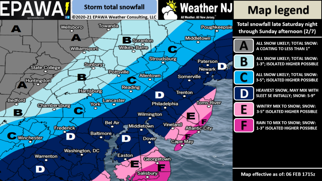
Zone C mostly affects the NWNJ elevations. We expect this zone to be on the NW side of the jackpot axis. No temperature issues at any layer, just a NW graze from a quick moving wintry system. If this system interacts more with the N energy branch then the D zone could be pushed further NW into the higher elevations. Bur for now, this makes the most sense given the current 500mb live observations.
Zone D is the jackpot axis. Only the SE side of this zone could mix at times and very briefly. Otherwise, it will be cold enough at all layers for snow to see a significant/plowable snow event. Again, the heavy wet kind of snow. Lots of compaction. If the wildcard redonkulous fronto situation happens, then someone in zone D or E could achieve double digit snow accumulations and possibly KABOOM. Again, that remains a small wildcard possibility. The map represents our most realistic evidence-based prediction:
In English: A snowstorm is approaching New Jersey for Sunday (tomorrow). It should arrive by sunrise, peak from late-morning through early-afternoon, and taper off by sundown. Parts of SNJ (likely SENJ) should start as a mix of sleet/rain after midnight tonight and change to snow by noon for the rest of the event tomorrow, barring any sleet pockets. I see accumulation issues, especially for roads in SENJ unless the wildcard meso bands park over said areas. One more reminder that the snowfall will be the heavy wet kind. No concerning wind or coastal flooding issues expected.
A light-to-significant snow event for NWNJ. Mixing issues for SENJ holding down accumulations to start. A significant-to-possibly major event for areas between. The map above represents our last forecast heading in. I’ll check back in later tonight when initial returns are approaching SNJ. Have a great rest of your Saturday and please be safe! JC
Jonathan Carr (JC) is the founder and sole operator of Weather NJ, New Jersey’s largest independent weather reporting agency. Since 2010, Jonathan has provided weather safety discussion and forecasting services for New Jersey and surrounding areas through the web and social media. Originally branded as Severe NJ Weather (before 2014), Weather NJ is proud to bring you accurate and responsible forecast discussion ahead of high-stakes weather scenarios that impact this great garden state of ours. All Weather. All New Jersey.™ Be safe! JC


LOCAL FORECAST | INTERACTIVE RADAR | LATEST NJ WEATHER ALERTS | WEDDING FORECAST| PRIVACY POLICY
© Copyright 2026 Weather NJ LLC. All Rights Reserved.
Some information that can be found on our website is provided by a private weather station and is not an officially recognized station for weather reporting. Though we always strive to achieve accurate reporting for our own use, it is important that you do NOT depend on the data provided here for any purpose.
