

Feb 6: Winter Storm Discussion
The February 8-10 period has been of great interest to me for a while now. Not because of any particular surface solution modeled, but because of the consistency in the modeled upper-level pattern. If you’re looking for how much snow the right side of your deck is going to see vs. the left side of your deck on Tuesday morning, then you’re not going to like this article. If you want to know what is possible given the many moving parts of a dynamic setup, then welcome and enjoy. If I’ve learned anything from Juno last January, it’s to make sure the public is well-informed of the possibilities and to know what to look for moving forward to determine which possible outcome should unfold in the last minute.
So here’s the latest upper-level map from the GFS. We’re looking at 500mb heights on Monday morning:
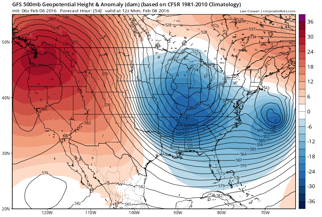
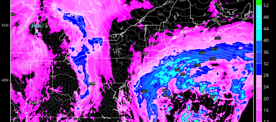
The upper-level energy over the Atlantic Ocean represents a very powerful low pressure system at the surface. That energy will be moving away to the NE (parallel to east coast). How close it comes to the east coast will be determined by how much interaction it has with the longer-wave deep trough swinging through behind it. If enough interaction in the upper levels happens, then the ocean low will pass closer to the east coast. This would mean a heavy thump of snow as early as Sunday night well into Monday (represented by the latest NAM in the cover image of this article). If there is less interaction between the ocean low and upper-level trough then it will miss out to sea. So those are your potential scenarios for the first possibility within this February 8-10 window.
After the coastal storm moves away, whether hit or miss, another piece of energy will move in from Canada. It’s basically a clipper that sprints to the Great Lakes area from Alberta and then transfers to the mid-Atlantic coast. This represents our second possibility Tuesday into Wednesday. At 500mb, it’s absolutely beautiful:
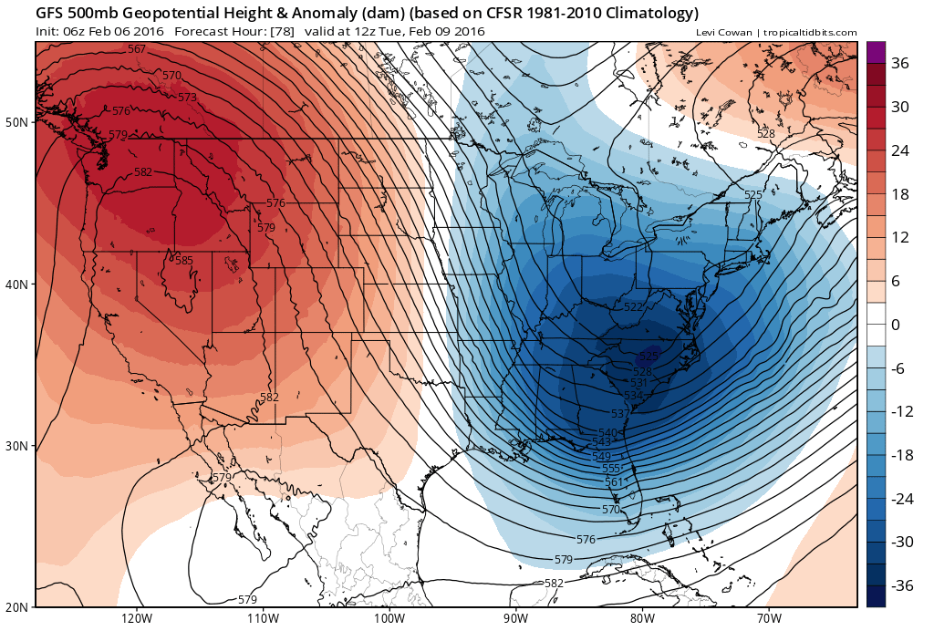
Look at the amplified W. US ridge as well as the deep E. US trough transitioning its axis from positive to neutral/negative. However, since we don’t have a single organized system at the surface, we see a possible inverted trough setting up. In my opinion, that would result in a prolonged period of light-to-moderate snow Tuesday into Wednesday rather than a more major event. However, if the dynamics phase a little tighter, then we could be looking at much heavier accumulations statewide.

So this is how we have to approach this. The Monday coastal and the Tuesday-Wednesday phase. The Monday coastal is currently supported by model guidance for an out-to-sea solution despite the NAM and SREFs bringing precipitation (as snow) well into New Jersey. Given the NW trends of the blizzard and yesterday morning in the prior 36 hours of guidance, I say we have to keep an eye on this just in case it follows suit. The Tuesday-Wednesday phase currently looks like light-to-moderate snow across the area (light accumulations only) but could also turn into a last minute monster. Both situations are highly volatile.
In English: This is your captain speaking. Please buckle your seat belt and return tray-tables and seats to their upright position. We will be flying through an area of turbulence (snow possibility) in the Monday-Wednesday period. Could be little-to-nothing at all. Could be major. But if it turns out to be major, you’ll be glad you were wearing your seat belt. This is the best and most honest I can do for right now. It’s now time to aggressively track model guidance. Be safe! JC
Jonathan Carr (JC) is the founder and sole operator of Weather NJ, New Jersey’s largest independent weather reporting agency. Since 2010, Jonathan has provided weather safety discussion and forecasting services for New Jersey and surrounding areas through the web and social media. Originally branded as Severe NJ Weather (before 2014), Weather NJ is proud to bring you accurate and responsible forecast discussion ahead of high-stakes weather scenarios that impact this great garden state of ours. All Weather. All New Jersey.™ Be safe! JC


LOCAL FORECAST | INTERACTIVE RADAR | LATEST NJ WEATHER ALERTS | WEDDING FORECAST| PRIVACY POLICY
© Copyright 2026 Weather NJ LLC. All Rights Reserved.
Some information that can be found on our website is provided by a private weather station and is not an officially recognized station for weather reporting. Though we always strive to achieve accurate reporting for our own use, it is important that you do NOT depend on the data provided here for any purpose.
