

Feb 7: Snow Map and Video Update
Here are my current thoughts on what to expect for Thursday’s winter snow storm…
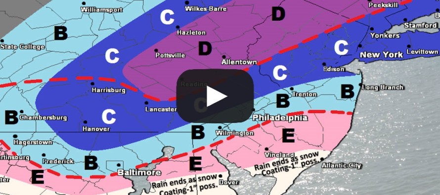
You can view the full-resolution snow map by clicking here.
Text Version of Video: The most recent model guidance (model guidance that post-dates this snow map creation) is indicating a colder and more powerful winter storm across New Jersey this Thursday morning. This means we’re likely going to make some changes to the map your seeing now. I’m fairly confident that NNJ will still see more snow than SNJ simply because the snow/rain line will be moving from NW to SE through this storm. So for the jackpot zone that should set up across most of NNJ (NW of the I-95 corridor), our current thinking remains at 6-10 inches of snow with a foot not off the table. The recent guidance and observations however are telling me that CNJ and SNJ are looking colder which would mean we have to raise those totals (light blue and pink area). We still feel that extreme SENJ would likely see the lowest accumulations after a mostly rain event. Therefore our most current thoughts basically take this map your seeing now and expand the lower boundaries to the SE, opening up a larger swath of widespread moderate-to-heavy snowfall. Tomorrow we will likely be moving towards these ideas with our adjusted and final call if overnight guidance and observations hold.
The upper-levels continue to trend favorably for winter storm development. The newest modeled W US ridge strength and E US trough axis are the best I’ve seen yet for this system. The surface guidance is responding to this with a sub-1000mb storm before it ejects into the Atlantic Ocean and shortly after, a sub 990mb storm before it reaches the 40N/-70W benchmark. It’s basically modeled to wind up better (stronger). For these reasons the precipitation shield, that backs in off the Atlantic Ocean, should be larger—reaching all the way into E PA. Cold air injection is possible via latent heat exchange from either higher precipitation rates and/or adiabatic cooling from sudden pressure drops. It’s cold as heck above 850mb and won’t take much to chill the entire storm down, especially with bottomed-out Atlantic Ocean sea surface temperatures. February winter storm dynamics at play.
This is a rain to snow event. Temperatures are going to crash and bottom out during this storm system from NW to SE. I know this seems unrealistic after some places hit 60F for a Wednesday high temperature…but it’s likely going to happen.
For the first time in a while now, I’ve got the K word dusted off and ready to deploy should 12 inches of snow appear imminent in the jackpot zone. Again, at this point we feel that jackpot zone is targeting NNJ in general with the highest accumulations.
In English: Rain is going to move in and change to snow between late Wednesday PM and Thursday morning. NNJ will changeover first followed by CNJ and lastly SNJ. For this reason NNJ should see the most snow. CNJ should see the second-most snow. And SNJ should see the least snow. Our snow map indicates our thoughts as of earlier today but just in the last few hours, models have trended towards a colder and stormier scenario. Our final call tomorrow will reflect our last thoughts heading into the live-casting period. Have a great night and please be safe! JC
Jonathan Carr (JC) is the founder and sole operator of Weather NJ, New Jersey’s largest independent weather reporting agency. Since 2010, Jonathan has provided weather safety discussion and forecasting services for New Jersey and surrounding areas through the web and social media. Originally branded as Severe NJ Weather (before 2014), Weather NJ is proud to bring you accurate and responsible forecast discussion ahead of high-stakes weather scenarios that impact this great garden state of ours. All Weather. All New Jersey.™ Be safe! JC


LOCAL FORECAST | INTERACTIVE RADAR | LATEST NJ WEATHER ALERTS | WEDDING FORECAST| PRIVACY POLICY
© Copyright 2026 Weather NJ LLC. All Rights Reserved.
Some information that can be found on our website is provided by a private weather station and is not an officially recognized station for weather reporting. Though we always strive to achieve accurate reporting for our own use, it is important that you do NOT depend on the data provided here for any purpose.
