

Feb 8: Monday Morning Observations
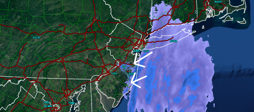
The coastal low has intensified below 980mb and continues to deepen. It’s located directly east of the Delmarva Peninsula but pretty far out to sea. It appears that the NW extent of its precipitation shield is just starting to impact Monmouth and Ocean County with some light rain. This rain should change over to snow and everything should pull away by noon. The atmosphere is cold enough for snow at 850mb and above. The surface however is likely not cold enough from 925mb down for stickage. So look for the rain to possibly change to snow (small period of sleet possible) for eastern parts of Monmouth and Ocean County only with nuisance conditions at most—ending by noon. The rest of the state should be okay for this first part of the overall complex forecast through Wednesday AM.
The far greater concern at the moment is moderate coastal flooding due to the enormous wind field being generated by the powerful low. Watch out for this through this evening’s high tide. The coastal flooding threat should subside by tomorrow morning.
Moving forward, the inverted trough will set up this evening into tomorrow. This is going to be a band of heavier snow that sets up from west to east about 30-50 miles wide. It could either hit NNJ, CNJ of SNJ with almost equal chances. Right now, I’m leaning towards the CNJ/SNJ areas but these inverted troughs can make fools of forecasters so that’s why I’m now-casting it. For those who find themselves under the heaviest bands of snow, 6-10 inches are possible. For those who find themselves just north or just south of the inverted trough band, you could see anything from lighter accumulations to hardly anything at all.

In English: Fringe impact from the coastal low is likely through about noon today (maybe early afternoon) for eastern Monmouth and Ocean Counties only. This includes rain moving in off the ocean possibly changing to snow with difficulty sticking due to a warmer surface temperature profile. Snow is then possible later this evening through tomorrow. Accumulations are expected to be widespread and light in general with someone (leaning towards CNJ/SNJ from west to east) seeing a jackpot zone of 6-10 inches. The jackpot location won’t be determined until it’s close to happening. I’ll put out another observation post early this evening when the inverted trough is setting up. Have a great day and be safe! JC
Jonathan Carr (JC) is the founder and sole operator of Weather NJ, New Jersey’s largest independent weather reporting agency. Since 2010, Jonathan has provided weather safety discussion and forecasting services for New Jersey and surrounding areas through the web and social media. Originally branded as Severe NJ Weather (before 2014), Weather NJ is proud to bring you accurate and responsible forecast discussion ahead of high-stakes weather scenarios that impact this great garden state of ours. All Weather. All New Jersey.™ Be safe! JC


LOCAL FORECAST | INTERACTIVE RADAR | LATEST NJ WEATHER ALERTS | WEDDING FORECAST| PRIVACY POLICY
© Copyright 2026 Weather NJ LLC. All Rights Reserved.
Some information that can be found on our website is provided by a private weather station and is not an officially recognized station for weather reporting. Though we always strive to achieve accurate reporting for our own use, it is important that you do NOT depend on the data provided here for any purpose.
