

Feb 8: More Snow
Discussion: There are seriously 5-6 winter storm signals over the next 12 days or so. Most appear to be light-to-significant with maybe a significant-to-major around Valentines Day. Let’s focus on the two immediate signals this week. Gonna have to start nicknaming them. We’ll call tonight into tomorrow “The North Jersey Grazer.” We’ll call Wednesday night through Friday morning “The Long Wave.”
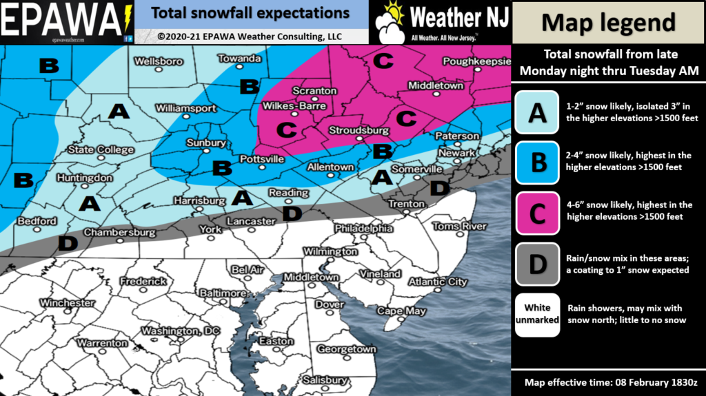
The North Jersey Grazer is an immediate light wintry signal for NNJ (along and N of I-78) overnight tonight into tomorrow (Tuesday). It could arrive any time after midnight tonight for NWNJ/WCNJ and taper off for NENJ/ECNJ by tomorrow (Tuesday) afternoon. Areas of NJ along/just N of the I-95/NJTP corridor area, between Trendon and NYC, could see snow to start but then mix to sleet or freezing rain. This would generally include WCNJ into NENJ. Most of SNJ and ECNJ will likely see all rain. This leaves NNJ elevations (N of I-80/NW of I-287) to see the highest accumulations from The North Jersey Grazer. For this system starting overnight tonight, we have a forecast snow map:
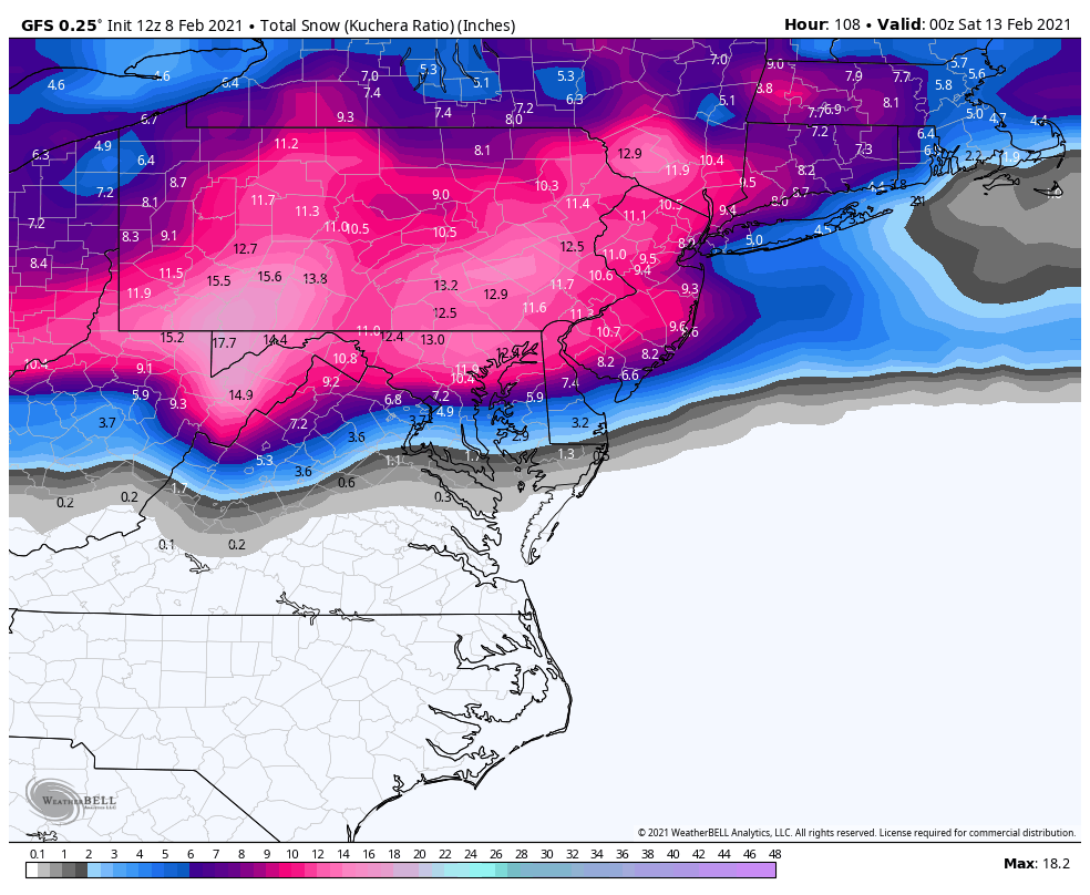
The North Jersey Grazer will then pull down colder air in its wake. That should push the critical thermal boundary down to the S of NJ for Tuesday into the weekend. This should set the stage cold enough for CNJ and SNJ to see a significant plowable snow event (4-8 maybe higher) from The Long Wave. I-78 would likely be the northern extent of higher snow accumulations, maybe I-80. All the areas in SNJ who were recently robbed by rain and sleet are targeted for the best snow accumulations with this one. I’m especially talking about all of Burlington and Ocean County, not just N parts of such…and all other areas down through at least Wilmington, DE-Atlantic City, NJ latitude. I would include the Vineland area too. The Polar Vortex energy lobe will be enforcing the cold which doesn’t let any part of this system turn to the N. There is still some uncertainty as to whether extreme SNJ (Cape May/S Cumberland) will be cold enough for snow. The GFS is a little warmer in that extreme SNJ area. The Euro is all snow for even Cape May. We have a few days to work out a consensus but we know there will be a very tight W to E thermal gradient with Arctic air to the N of it and warm moist air to the S. My gut says this will be just over or just to the S of Cape May. The Long Wave should approach Wednesday evening from the W. The first part snows through most of Thursday morning. NJ then sees a lull from Thursday afternoon into Friday morning. The second part of The Long Wave then snows from Friday late-morning through Friday evening. Again, I think this should bring a 4-8 inch type event to most of CNJ and SNJ leaving NNJ on the lesser side. Just remember that it is a prolonged event with a lull in the middle, not an all at once dumping like yesterday. Here’s the GFS showing its general idea after both systems. Snow amounts are shown using Kuchera to better assess the expected higher snow ratios/colder snowfall:
The next winter storm signal after that is the Valentines Day period (Feb 14). This one looks more capable of turning into a major snowstorm as we closer approach. Right now, it is too uncertain to suggest a forecast or gut surface solution. But almost every model run is nailing someone in the general northern Mid-Atlantic US. I imagine we’ll have a much better idea by Friday when The Long Wave is tapering off. After that there are wintry hits showing for Feb 17, Feb 19, and Feb 22. An extremely active pattern with lots of cold air available. It doesn’t seem to let up as far as I can see in February. Also coastal ocean sea surface temperatures will be at their annual lowest (near-40 possibly in the upper-30s) during this range. This is why the month of February statistically favors ECNJ/SNJ for snow.
In English: A light but still plowable snowfall is likely for NNJ (along and N of I-78) after midnight tonight. Warmer rain for most of CNJ and all of SNJ. It should wrap up by tomorrow afternoon (see above snowfall map). The entire state of NJ then returns to cold for the rest of the weekend. Between Wednesday night and Friday evening, most of CNJ/SNJ are looking at a prolonged plowable event. The prolonged wintry wave should come in the form of snow Wednesday PM through Thursday AM, a lull Thursday PM into Friday AM, then snow Friday AM through Friday PM. These two events are just for this week. Other wintry storm signals are showing for Valentine’s Day (could be larger snowstorm) and beyond. The Arctic Cold is expected to sit just to our N through most of it—available to inject cold where needed to make snow. Buckle up folks. Be safe! JC
Jonathan Carr (JC) is the founder and sole operator of Weather NJ, New Jersey’s largest independent weather reporting agency. Since 2010, Jonathan has provided weather safety discussion and forecasting services for New Jersey and surrounding areas through the web and social media. Originally branded as Severe NJ Weather (before 2014), Weather NJ is proud to bring you accurate and responsible forecast discussion ahead of high-stakes weather scenarios that impact this great garden state of ours. All Weather. All New Jersey.™ Be safe! JC


LOCAL FORECAST | INTERACTIVE RADAR | LATEST NJ WEATHER ALERTS | WEDDING FORECAST| PRIVACY POLICY
© Copyright 2026 Weather NJ LLC. All Rights Reserved.
Some information that can be found on our website is provided by a private weather station and is not an officially recognized station for weather reporting. Though we always strive to achieve accurate reporting for our own use, it is important that you do NOT depend on the data provided here for any purpose.
