

Feb 9: South Jersey Express
Discussion: The light North Jersey Grazer event concluded earlier today. Overall, not a big deal especially after last week’s snowfall. As expected, the extreme NNJ elevations did best with amounts gradually tapering off near I-80/I-70 as you move from extreme NNJ to lower elevations of NNJ.
We now turn our heads to The Long Wave. This will not be a powerful snowstorm with a rapidly deepening low. It will likely just a prolonged plowable/significant event that pushes through mainly SNJ in two batches of precipitation. One batch late Wednesday night through about noon on Thursday then another batch late Thursday night through Friday morning. A lull is expected between (from noon Thursday until after sunset Thursday) where the N extent of precipitation is expected to sink into extreme SNJ before returning northward for the second batch.
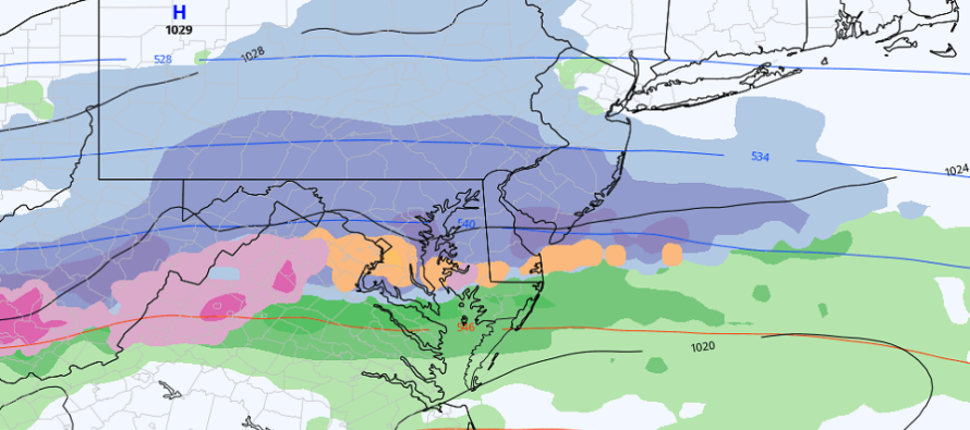
This system is heavily targeting the central Mid-Atlantic US for the jackpot accumulations of snow (West Virginia, N half of VA, Maryland, Delmarva, and Cape May). I would be very surprised if this didn’t trend slightly N over next 24-36 hours of data runs and live observations. These kinds of systems tend to do this 9 out of 10 times. However as currently modeled verbatim, Cape May should see the most snow accumulations with amounts tapering to just trace snow as you move northward in NJ up to about I-195. Perhaps snow showers with little-to-no accumulation make it as far N as the I-78 area. But most accumulations are going to S of a line drawn from Philly to Toms River across S/C NJ.
About 75% of accumulations should come from the first batch of precipitation (late Wed PM to noon Thurs). The remaining 25% of snow accumulations should fall with the second batch (late Thurs PM through noon Friday)….after the Thursday PM lull.
Here is some of the shorter-range guidance I am considering, along with live obs, to form my general idea. The latest NAM (top) and RGEM (bottom):
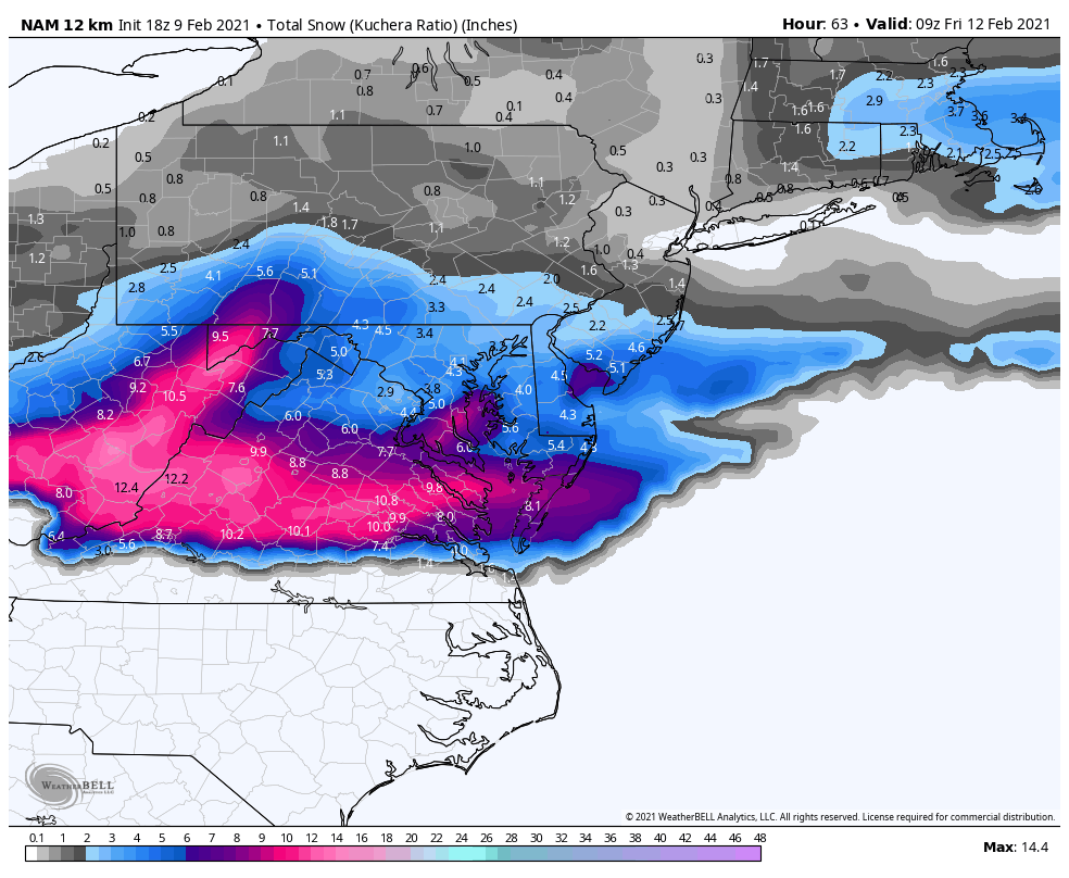
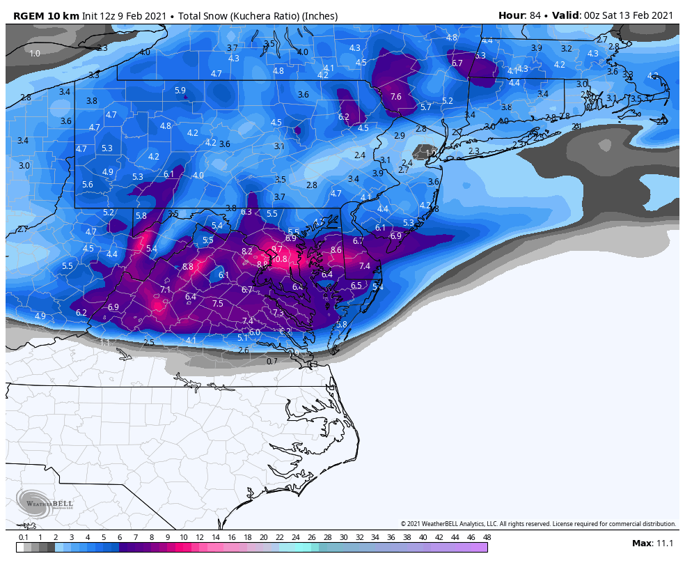
Side note: The Canadian models, such as the short range RGEM above, tend to perform better when there is very cold air mass over Canada. Sort of a home field advantage type thing with the sensors and data. The only reason there is snow in NNJ is because it’s the 12Z RGEM from around noon today and still included ending snowfall from the North Jersey Grazer. Also the NAM has most snowfall in the first batch of precipitation and hardly any in the second.
In English: Snow is likely between late Wednesday night and Friday morning with SNJ, especially extreme SNJ, targeted for the best snow accumulations. It should be cold enough for all of SNJ to snow (no rain or mixing). It’s not an all at once type thing like Sunday. Most falls between late-Wed night and noon on Thursday. A break from noon Thursday to Thursday evening. Then the last of it should fall Thursday overnight into Friday morning. Tomorrow we will have a forecast map out. But for right now my gut says zero to 6 inches from I-195 down to Cape May. that would put places like Salem County and the Toms River latitude around 4 with again Cape May taking the jackpot. Let’s see how the data and observations continue to unfold. Have a great rest of your Tuesday and please be safe! JC
Jonathan Carr (JC) is the founder and sole operator of Weather NJ, New Jersey’s largest independent weather reporting agency. Since 2010, Jonathan has provided weather safety discussion and forecasting services for New Jersey and surrounding areas through the web and social media. Originally branded as Severe NJ Weather (before 2014), Weather NJ is proud to bring you accurate and responsible forecast discussion ahead of high-stakes weather scenarios that impact this great garden state of ours. All Weather. All New Jersey.™ Be safe! JC


LOCAL FORECAST | INTERACTIVE RADAR | LATEST NJ WEATHER ALERTS | WEDDING FORECAST| PRIVACY POLICY
© Copyright 2025 Weather NJ LLC. All Rights Reserved.
Some information that can be found on our website is provided by a private weather station and is not an officially recognized station for weather reporting. Though we always strive to achieve accurate reporting for our own use, it is important that you do NOT depend on the data provided here for any purpose.
