

Feb 9: Tuesday Morning Observations
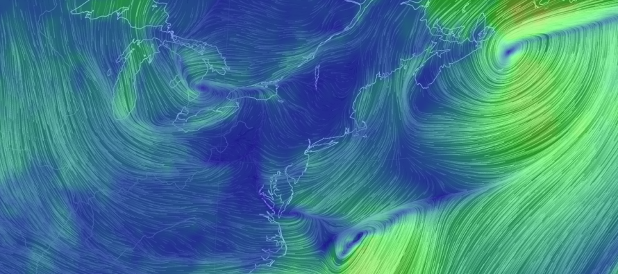
Low pressure has jumped to the Mid-Atlantic coast and is moving out to sea. You can make out the cyclonic flow east of OBX on the Earth map image. Low pressure will also remain behind over the Great Lakes. The inverted trough should set up to its west and focus precipitation over our region today through tomorrow morning. I’m seeing E/NE onshore flow assisted by the western side exhaust of the system that moved through yesterday morning. This tells me that moderate coastal flooding should continue through today, especially during high tides. It also tells me that the bottom levels of the atmosphere will be above freezing for most of the day, presenting a horrible environment for snow stickage (at least for lower 2/3 of NJ).
So even if the heaviest precipitation targets CNJ/SNJ, the line of freezing at the surface will favor accumulations north of I-195 rather than south of it. Those to the north of I-195 would then be able to accumulate but should lack the precipitation. At this point I just don’t see much in the form of wintry accumulations for at least the first part of today. Let’s call it through 5PM. This works out in favor of schools and other organizations worried about closings and/or cancellations. Most should be okay today.
Moving forward beyond 5PM, temperatures should drop with the loss of both sun and onshore flow. Winds should become more northerly as the final dynamics of this system take shape. You really have to toss all snow maps out the window at this point. When all is said and done tomorrow morning, I think we’re looking at a statewide 1-3 with someone possibly seeing 3-6. I would currently lean towards CNJ but parts of NNJ and SNJ are all on the hook. As I’ve tried to communicate over the past few days, the uncertainty is astounding.
In English: Final accumulations through tomorrow should be on the lesser side of expectations. Coastal flooding from persistent onshore flow is the main story today despite the precipitation you should see falling. The ground is just too warm and I’m not confident in precipitation falling hard enough to overcome such south of I-195. North of I-195 is cold enough for accumulations but I’m skeptical how much moisture even gets to NNJ today. Once the sun sets, temperatures should fall in favor of a widespread light snowfall overnight and through tomorrow morning. 1-3″ widespread and possibly 3-6 for the areas that see the heaviest snowfall (WNJ favored over ENJ). Such areas again, will have to be now-casted. Did I mention that I dislike forecasting inverted troughs? Look for an early evening update. Have a great day and be safe! JC
Jonathan Carr (JC) is the founder and sole operator of Weather NJ, New Jersey’s largest independent weather reporting agency. Since 2010, Jonathan has provided weather safety discussion and forecasting services for New Jersey and surrounding areas through the web and social media. Originally branded as Severe NJ Weather (before 2014), Weather NJ is proud to bring you accurate and responsible forecast discussion ahead of high-stakes weather scenarios that impact this great garden state of ours. All Weather. All New Jersey.™ Be safe! JC


LOCAL FORECAST | INTERACTIVE RADAR | LATEST NJ WEATHER ALERTS | WEDDING FORECAST| PRIVACY POLICY
© Copyright 2026 Weather NJ LLC. All Rights Reserved.
Some information that can be found on our website is provided by a private weather station and is not an officially recognized station for weather reporting. Though we always strive to achieve accurate reporting for our own use, it is important that you do NOT depend on the data provided here for any purpose.
