

February 2020 Outlook

It’s time to harness WeatherTrends360 technology and look at how the rest of February 2020 should play out. WeatherTrends360 algorithms are documented with an 84% verification rate and are based on oceanic water cycles, time table series and very complex mathematics. The best takeaway from this data are general trends (cool vs warm, rainy vs dry, etc). I’m always hesitant to forecast specific surface conditions (rainfall amounts, snowfall amounts, winds, etc) beyond the 7 -day forecasting period. But general temperature and precipitation trends are what WeatherTrends360 does best with their proprietary mathematical analysis derived from over 150 years of reactive pattern data. For this reason, let’s call this a long-range discussion of reasonable expectations rather than a locked-in long-range forecast. You’ll never see me commit to specific surface conditions outside of the 7-day forecasting period.

The following diagram is calculated using WeatherTrends360 proprietary algorithms for New Jersey in general. Please keep in mind that micro-climate influences can vary. NWNJ elevations and SNJ Pine Barrens (away from the ocean), for example, will verify slightly colder than illustrated due to elevation and soil heat exchange. Interior CNJ/SNJ (closer to N Delaware/Philly/Trenton – I-95 corridor into NENJ) slightly warmer than illustrated due to urban heat island effect and several other influencing factors. All areas of NJ however would have similar graph trends and sky conditions. It’s best to let the following graph paint an overall picture (trends) instead of focusing on the low-level specific condition details.
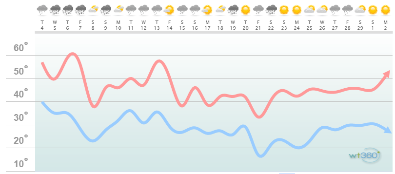
Discussion: The WeatherTrends360 algorithms are consistent with two anomalous upper-level ridges over the E US. The first being this week (today through ~Friday Feb 7) and the second being next week (~Feb 11-14). Conditions at the surface should feature above-average temperatures during these times which dominates the first half of February. Between those two periods of upper-level ridging exists a cold period around Feb 7-10 (this Friday night through Monday). This transient cold shot is produced from a trough spilling into the US and dragging down some colder Canadian air before lifting out and allowing the ridge to re-build. It’s not the true Arctic cold air that’s bottled up near the N Pole. But cold enough to produce wintry precipitation hence the weak/light snow event we’re tracking for this weekend.
The Arctic Oscillation (AO) and North Atlantic Oscillation (NAO) are expected to reach near-record positive values around Feb 10 before falling back to near-neutral/slightly positive for the rest of February. This indicates that the true Arctic/Polar Vortex outbreak air mass should remain bottled up tightly near the N Pole with the stratospheric and tropospheric vortices. It also indicates that we will not see a strong blocking signal over Greenland—preventing any coastal systems from stalling out/retrograding into major snow storms. Instead most systems should progressively and quickly flow through. The Pacific North American (PNA) oscillation is expected to remain negative which tells me we won’t see any periods of prolonged ridging in the W US—which goes hand-in-hand downstream for the E US (no deep troughs). We are however expecting the Eastern Pacific Oscillation (EPO) to remain negative which is the only favorable teleconnection for winter weather in the E US mostly in the form of thread-the-needle smaller events.
The second half of February looks to get back to seasonably average temperatures but we’re getting closer to spring every day now and hours of sunlight/sun angle are increasing. This means that daytime snowfall will soon have trouble sticking to paved surfaces. It would have to fall overnight. The ocean is at it’s annual coldest however so this mitigates coastal plain warming slightly from easterly wind components off the ocean. We still have a few innings left of the winter ballgame but if a rally is going to happen, it needs to start this weekend. And again there is low support for a major snow storm but plenty of chances for smaller events given how active the pattern is. We still have some second-half February periods where highs max out in the 30s and lows fall to teens/20s. Winter is not over but it’s been close to non-existent so far. Then there’s always March which can either produce an early warm spring or a back-loaded never-ending winter (like 4 out of 6 recent Marches. We’ll cross that bridge later this month.

In English: The first half of February should feature above-average temperatures and above-average precipitation. The second half of February should feature near-average temperatures and precipitation. No major snow storms are currently on the horizon but a few smaller thread-the-needle wintry events are possible with the very active pattern in-place (ex: this Thursday morning’s ice storm and this weekend’s light snowfall chances). As always I’ll report accordingly on any wintry threats that pop up in the 7-day forecasting period. Have a great February and please be safe! JC
Jonathan Carr (JC) is the founder and sole operator of Weather NJ, New Jersey’s largest independent weather reporting agency. Since 2010, Jonathan has provided weather safety discussion and forecasting services for New Jersey and surrounding areas through the web and social media. Originally branded as Severe NJ Weather (before 2014), Weather NJ is proud to bring you accurate and responsible forecast discussion ahead of high-stakes weather scenarios that impact this great garden state of ours. All Weather. All New Jersey.™ Be safe! JC


LOCAL FORECAST | INTERACTIVE RADAR | LATEST NJ WEATHER ALERTS | WEDDING FORECAST| PRIVACY POLICY
© Copyright 2025 Weather NJ LLC. All Rights Reserved.
Some information that can be found on our website is provided by a private weather station and is not an officially recognized station for weather reporting. Though we always strive to achieve accurate reporting for our own use, it is important that you do NOT depend on the data provided here for any purpose.
