

February Snow Pattern Emerging
Discussion: Before we talk about this “NSFW snow lover content” I want to set a few expectations and reality checks. First, big snow is not guaranteed every year in New Jersey. Heck, sometimes even small snow is not guaranteed every year in New Jersey. We’ve been through at least a handful of winters in the past few decades where total winter snowfall amounted to less than an inch. Second, Arctic outbreaks are not guaranteed every year either. We had a 10-day period of Arctic-influenced cold earlier this month. I remember a solid 2 week stretch in Jan 2018, a solid 3 week stretch in Winter of 2013-2014 (Polar Vortex outbreak), and maybe a few other 1-2 week periods going back to the 1990s. It’s certainly not how the silent type/boomers describe in the 1960s and before where cars drove across bays to barrier islands. Third, we’re simply in a warmer time now where cold periods are more transient and occur in more of a few and far between manner. However in this warmer present climate, the more transient cold periods are able to reach anomalous/record levels easier before going back to warmer prolonged patterns. Do you remember how the January 2016 storm occurred within a raging El Nino winter? And how it was warm leading up to it and warm just after? January 1996 was probably the last snowstorm where I remember a bitter cold leadup, bitter cold snowfall, and bitter cold period after that lasted for weeks. It’s been since winter of 2020-2021 that NNJ saw historic snow. It’s been since Jan 2022 since SNJ/ECNJ has seen a major snowstorm. There’s a stretch in WCNJ and surrounding areas that have not seen major snow since 2018. I hope this sets a realistic expectation of snow frequency for New Jersey, especially everyone along and SE of the I-95/NJTP corridor who are always subject to warmer marine influence.
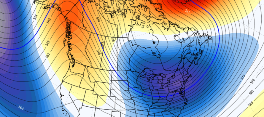
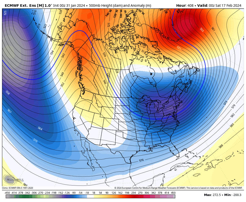
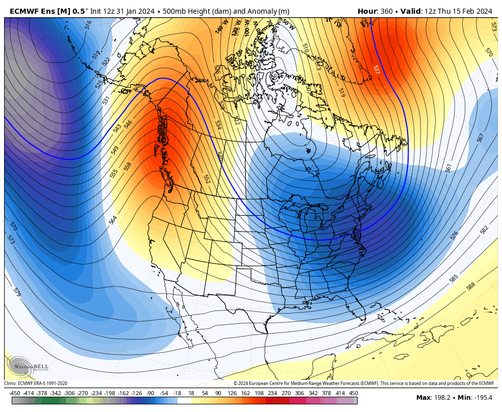
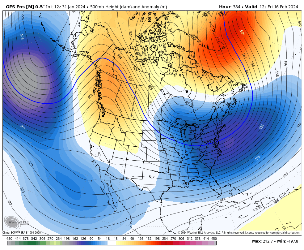
With that said, let’s talk. We knew this wasn’t going to be a winter of prolonged cold, at least not to start with the peaking El Nino in December-January. But now we’re facing sort of a snap-back scenario. The first 10-14 days of February will likely be too mild for snow outside of a few thread-the-needle smaller opportunities. There’s good confidence on that. But From Feb 13/14 and beyond, it looks to change towards a cold and active winter pattern. A hat tip to Bobby Martrich, of EPAWA Weather Consulting, for identifying a positive phase of the Indian Ocean Dipole (IOD) indicator. This means that the warm waters in the Indian Ocean have pushed west towards E Africa and the E waters of the Indian ocean are now colder and this is a sign of El Nino’s demise. This should begin to relax the raging Pacific Jet that has made the lower-48 US generally mild this winter (outside of the Jan cold period). Once this Pacific jet relaxes, the lower-48 US can then change into more of a meridional jet pattern with slower moving systems backed up from Greenland blocking. With all of this said, the data is pointing towards a very favorable pattern for east coast snowstorm development from Feb 13/14 through at least the end of February possibly into early March. The long range data is screaming for a trough in the E Pacific (-EPO), a ridge over the W US (+PNA), an east coast trough with Arctic air spilling down into it (-AO) and a blocking signal over Greenland (-NAO). Additionally, the MJO, which indicates the greatest tropical forcing along the equator in the Pacific Ocean, is indicating a phase 8. Here are the outputs for the period of interest from the Euro Weeklies, Euro Ensembles, GFS Ensembles, and Canadian Ensembles. It’s the most unanimous long-range signal I’ve ever seen.
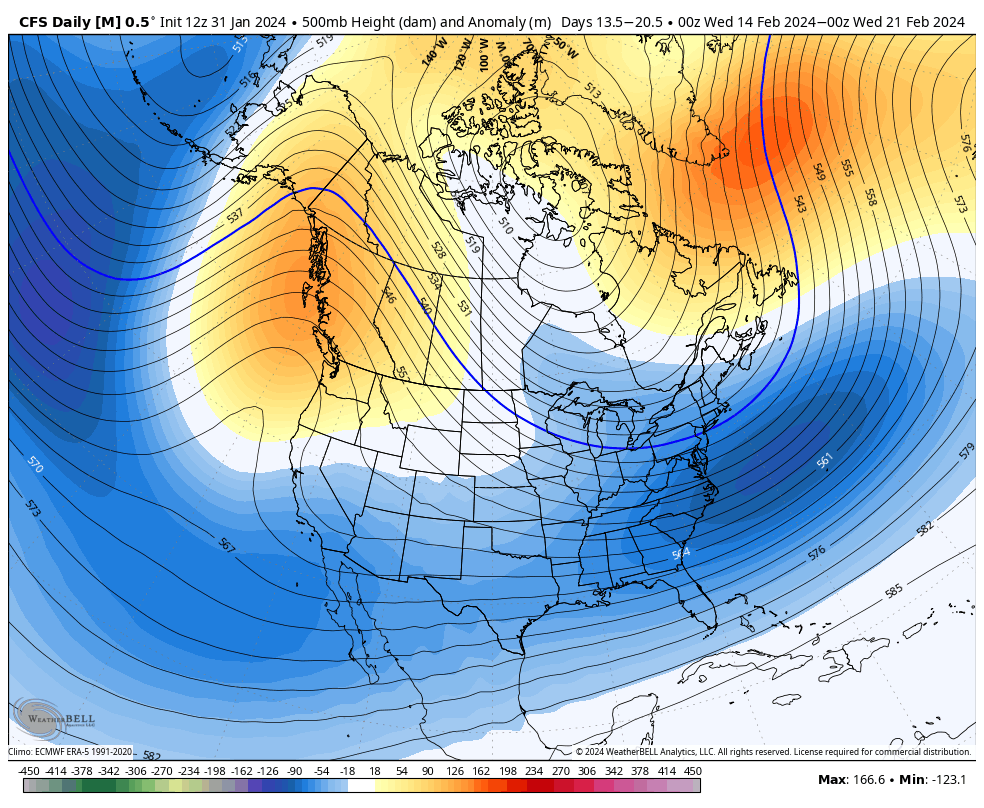
So what is the best takeaway from all of this? Don’t focus on a single storm just yet. There will be many starting to show on surface model guidance in fantasy range. They will appear and disappear. As they come and go, snow lovers and snow haters will experience both euphoria and heartbreak in alternating sessions. Don’t drive yourself crazy. This simply means that a prolonged period of favorable snowstorm development is likely coming Feb 13/14 and will hang around a while. Somewhere in that period, I think we have a good chance for at least one major snowstorm alongside the typical smaller systems that introduce and exit us out of the pattern. All the ingredients are on the table. The mixing bowls are out. The oven is pre-heated. Will the baker bake us cake? This is yet to be determined. But again, this is one of the best patterns for snowstorm development I’ve seen in a long time.
In English: There are a few small chances for snow here and there over the next 10-14 days. For example, some snow could fall this Thursday night late into Friday morning along the cold front. Accumulation expectations are low (most likely trace). Otherwise, we should continue a more general milder feel to winter until about Feb 13/14. From Feb 13/14 until at least the end of Feb, possibly into early March, our east coast weather pattern should enter a very favorable setup for snowstorm development. I’ve never seen agreement in data like the above images of the upper-level setup before. For this reason, these images are NSFW for the snow lover. No specific storm details yet. Just a favorable pattern that I expect at least one snowstorm to form in, possibly more (start and end of the pattern). Something to look forward to for the snow lover. Until then, we hurry up and wait. And after that period, winter will likely be over snow-wise. Let’s all get ready for a possible winter finale to remember. Be safe! JC
Premium Services
KABOOM Club offers inside info forecast discussion, your questions answered, and early storm impact maps (ahead of the public). At a buck per month, it’s an extremely feasible way to show support.
My Pocket Meteorologist (MPM), in partnership with EPAWA Weather Consulting, offers professional/commercial interests, whose businesses depend on outdoor weather conditions (snow plowing, landscaping, construction, etc.), with hyper-local text message alerts/forecasts and access to the MPM premium forum—the most comprehensive and technical forecast discussion available for PA and NJ.
Get your KABOOM Inside Out pajamas and more at the KABOOM shop!
Jonathan Carr (JC) is the founder and sole operator of Weather NJ, New Jersey’s largest independent weather reporting agency. Since 2010, Jonathan has provided weather safety discussion and forecasting services for New Jersey and surrounding areas through the web and social media. Originally branded as Severe NJ Weather (before 2014), Weather NJ is proud to bring you accurate and responsible forecast discussion ahead of high-stakes weather scenarios that impact this great garden state of ours. All Weather. All New Jersey.™ Be safe! JC


LOCAL FORECAST | INTERACTIVE RADAR | LATEST NJ WEATHER ALERTS | WEDDING FORECAST| PRIVACY POLICY
© Copyright 2025 Weather NJ LLC. All Rights Reserved.
Some information that can be found on our website is provided by a private weather station and is not an officially recognized station for weather reporting. Though we always strive to achieve accurate reporting for our own use, it is important that you do NOT depend on the data provided here for any purpose.
