

Feb 5: Winter Storm Targeting New Jersey
Discussion: The upper pattern data is gaining confidence in the N branch digging and hanging back a little, allowing the S branch to catch up and take the upper-level trough axis to near-neutral. East coast heights respond higher and take the S branch in for a NJ snow event. The N branch does not phase in but provides enough interaction to reinforce and possibly enhance the precipitation shield to the NW (over most of NJ). The primary energy from this system will be from the S branch of vorticity. Therefore I think we can lock the upper level pattern in from here and work downwards to the surface. This kind of N and S stream interaction aligns with most snow significant (6 inches) to low end of major (one foot) snow events that target SNJ like this one is now doing.
Without a full phasing, it will be a quick mover but still provide 6-12 hours of moderate-to-heavy snowfall somewhere in the general 3AM to 6PM window of Sunday. maybe an hour of light snow to start and finish on each side of the heaviest bands. SNJ would start first as light-to-moderate snow, as early as pre-dawn. Some SENJ locations could start as a mix or rain. Snowfall should then takeover and become heavy by noon while expanding well into NJ. NWNJ will likely be on the other side of the jackpot (the NW cut-off). The jackpot axis, on most guidance, is targeting most of NJ along and SE of the I-95/Turnpike corridor. The precipitation shield should then end and taper from W to E between afternoon and early evening hours. Sunday night into Monday would then be cold and clear with lows down to teens/20s NNJ/SNJ.
We see no temperature problems for areas along and just SE of the corridor (inside our jackpot zone). But there will likely be temperature issues for extreme SENJ. Ocean temps are running a little warmer than average which can assist a marginal environment at the surface for stickage. It could get as high as 35/36 if under a dry area but down to 28 if it’s snowing hard and bringing cold air aloft down. I expect to see convective signature banding given that milder surface layer that will want to rise into colder air aloft. Also we see a period of initial sleet possibly mixing as far in as the SE edge of our jackpot range. So for these reasons we’ve tapered the immediate SENJ coast, and areas inland as you go S, with expectations to account for typical marginal temperature marine issues. You shouldn’t have to go too far away from the ocean to get in on heavy snow though.
The map illustrates our expected accumulations. It’s not a big storm, especially after the last one, but it should provide at least a significant (plowable) snowfall across much of NJ. The highest range that could occur IMO would be isolated areas nearing a foot.
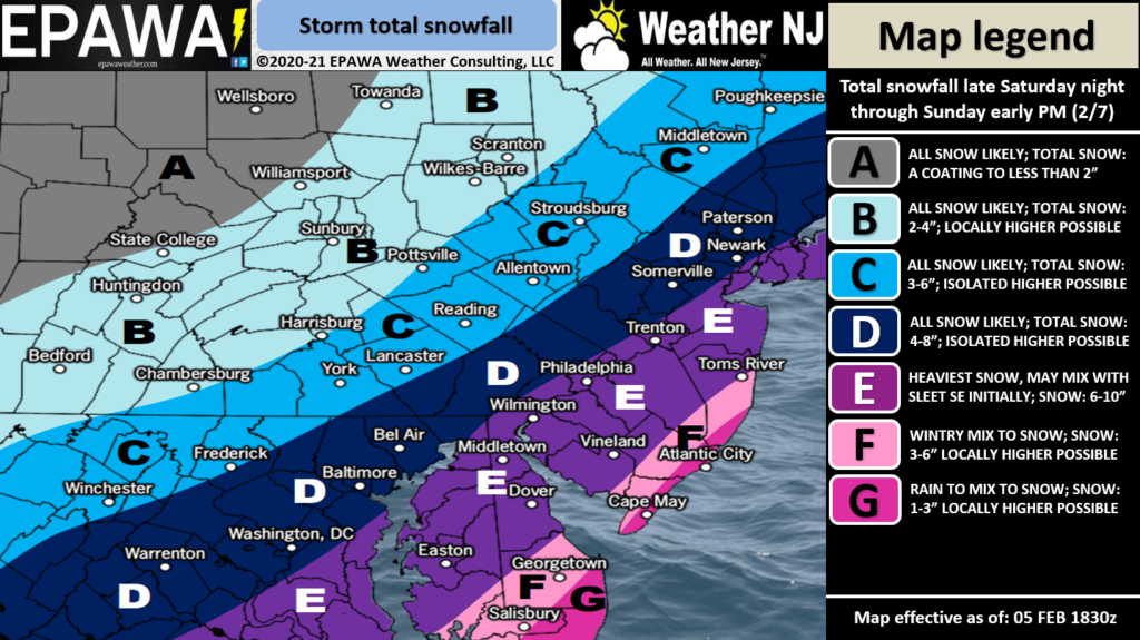
There is wildcard potential that frontogenic forcing rates are high enough to completely overcome the marginal SENJ temperatures. It would snow heavy enough to bring below-freezing air aloft down and crush the surface cold enough even to extreme coastal SENJ. This would naturally take some areas away from the ocean near the one foot of snow mark. We’ll see how it shakes out but my gut is starting to lean towards the idea. Nothing confident enough to factor into the evidence-based snow map above…just seeing how so many of these have gone down in SNJ.
In English: Most should wake up to the start of a New Jersey snowstorm Sunday morning. It should move in between 3-7am, snow for most of the day, and end just before Super Bowl LV. The map above indicates our initial expected accumulation amounts. No real wind or coastal flooding issues with this one. Windier along the coast with water levels up a few inches but nothing surge-wise to worry about. Around the same time tomorrow we’ll adjust if needed heading into the event. With that said, I wouldn’t put too much emotion into this specific surface suggestion. There is time for the data to trend slightly overnight and tomorrow. It is better to walk away just knowing in general that at least a significant/plowable snowstorm is targeting CNJ/SNJ this Sunday.
After a mild day today, overnight temps should fall into the 20s/30s NNJ/SNJ. Highs tomorrow reach 30s/40s (NNJ/SNJ) with calm conditions then drop to 20s/low-30s tomorrow night heading into the snowstorm Sunday morning. Everyone have a great rest of your Friday and please be safe! JC
Jonathan Carr (JC) is the founder and sole operator of Weather NJ, New Jersey’s largest independent weather reporting agency. Since 2010, Jonathan has provided weather safety discussion and forecasting services for New Jersey and surrounding areas through the web and social media. Originally branded as Severe NJ Weather (before 2014), Weather NJ is proud to bring you accurate and responsible forecast discussion ahead of high-stakes weather scenarios that impact this great garden state of ours. All Weather. All New Jersey.™ Be safe! JC


LOCAL FORECAST | INTERACTIVE RADAR | LATEST NJ WEATHER ALERTS | WEDDING FORECAST| PRIVACY POLICY
© Copyright 2025 Weather NJ LLC. All Rights Reserved.
Some information that can be found on our website is provided by a private weather station and is not an officially recognized station for weather reporting. Though we always strive to achieve accurate reporting for our own use, it is important that you do NOT depend on the data provided here for any purpose.
