

Final Call for Tuesday NWNJ Snow
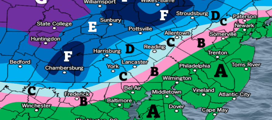
Discussion: We’ve beat this weak NWNJ snow event to death at this point. This is our final call map heading into it. Live observations will begin late tonight as we look at the precipitation approaching from the W in real-time. You can already see it on national radar. Here are what I believe the key takeaways are:
1) Precipitation pushes into WNJ just before sunrise Tuesday morning and spreads into the rest of NJ by sunrise or just after. Precipitation falls through the rest of Tuesday morning into afternoon and wraps up by about 5pm.
2) A snow/rain line could set up further S than you would expect in the morning but everyone S of I-78/SE of the Turnpike should quickly change to rain with possibly a period of sleet during the transition with little-to-no accumulation.
3) This is NWNJ’s snow event mainly for elevations above 800ft. Sussex County should see the highest accumulation amounts with eventually little-to-no accumulations S of I-80 and SE of I-287 regardless of any initial wintry precip bursts. We’ll be fighting daytime climatology (avg highs of 45-50F) along with a warm fetch from the S and off the ocean over near-50F ocean temps. With a wave this weak, that’s going to roast out the coastal plain with above-32F rain well to the N and W of I-95/NJTP.
4) Tuesday morning rush hour could be dicey whether snow, ice or rain. Obviously wintry precip on the ground is more hazardous but wet weather in general also carries risks and likely some delay. So I recommend allowing a little extra travel time.
Wildcards: 1) If the low is stronger with more of a NW track, then the snow will be even more confined to extreme NWNJ. 2) If the precipitation arrives earlier than just before sunrise (when it is colder), then an initial snowy burst could surprise some of the lower elevations and interior coastal plain as far S and E as I-195/NJTP…but we are leaning no further S and E than I-78/I-287. Anything that potentially falls prior to 6am has a great chance to fall as snow, especially N of I-195/NW of the Turnpike. Just keep in mind that any surprise wildcard accumulations further S will eventually be wiped out by warmer temperatures and rain. 3) If the low is weaker than expected with a flatter track, then a colder solution like yesterday’s first call snow map could verify. So I will be watching low intensity, low track and timing very closely. Otherwise, this snow map is adjusted from the most recent 24 hours of model data/live observations and represents our best middle-of-the-road evidence-based call:
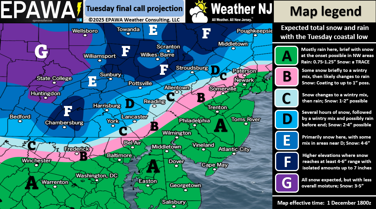
In English: It’s going to snow in the NWNJ mountains tomorrow morning-afternoon but should rain everywhere else in NJ. It might start out snowier in the morning for points further S but the snow/rain line will eventually, if not quickly, push northward throughout the light event. The snow is far from a monstrous event, especially by NWNJ standards. It’s not a big deal but could present a hazardous morning rush hour commute. Afternoon/evening rush hour commutes could be dicey for untreated roads N of I-80 and NW of I-287. Either way, allow for some slow-going travel delays Tuesday rain or snow. All snow/sleet/rain should end by about 5pm Tuesday with a solid temp drop Tuesday night into Wednesday morning behind the departing system. Most roads should dry before freezing but please use your head in case not! Be safe! JC
Premium Services
KABOOM Club offers ad-free content, inside info forecast discussion, your questions answered, and early storm impact maps and video releases (ahead of the public). At $1.99 per month, it’s an extremely feasible way to show additional support for Weather NJ and you can turn it on and off for however many months you wish. Think of it as a tip jar with perks. Available onFacebook or Patreon.
My Pocket Meteorologist (MPM), in partnership with EPAWA Weather Consulting, offers professional/commercial interests, whose businesses depend on outdoor weather conditions (snow plowing, landscaping, construction, etc.), with hyper-local text message alerts/forecasts from real meteorologists and access to the MPM premium forum—the most comprehensive and technical forecast discussion available for PA and NJ.
KABOOM Shop is live if you want some KABOOM or Weather NJ Merch!
Jonathan Carr (JC) is the founder and sole operator of Weather NJ, New Jersey’s largest independent weather reporting agency. Since 2010, Jonathan has provided weather safety discussion and forecasting services for New Jersey and surrounding areas through the web and social media. Originally branded as Severe NJ Weather (before 2014), Weather NJ is proud to bring you accurate and responsible forecast discussion ahead of high-stakes weather scenarios that impact this great garden state of ours. All Weather. All New Jersey.™ Be safe! JC


LOCAL FORECAST | INTERACTIVE RADAR | LATEST NJ WEATHER ALERTS | WEDDING FORECAST| PRIVACY POLICY
© Copyright 2026 Weather NJ LLC. All Rights Reserved.
Some information that can be found on our website is provided by a private weather station and is not an officially recognized station for weather reporting. Though we always strive to achieve accurate reporting for our own use, it is important that you do NOT depend on the data provided here for any purpose.
