

Final Call Heading into Tonight
Discussion: After reviewing overnight mesoscale model guidance and comparing to live observations on SPC mesoscale analysis, we have the best idea we’re going to have heading into this system. This article and included snow impact map represents the final forecast discussion prior to live storm observations.
The NAM model was the most aggressive up until yesterday with the InVerted Trough (IVT) impact bringing larger snowfalls further S into NJ. The NAM was an outlier as most other model guidance favored NNJ only (N of I-80). As of this morning, the NAM backed off and now resembles most other model guidance with an I-80 and N only hit for snow accumulations. Areas S of I-80 will see snowfall but struggle to accumulate anything more than a sloppy coating.
The initial components of this system have already begun. Obviously, rain has started for NJ and temps are into the 40s for most with the exception of areas N of I-80/NW of I-287. We knew this is how it would start today with the snow/rain line establishing near that I-80/I-287 location or even N of that. The primary low is fizzling out over NY state and will fully transfer to the secondary coastal low currently establishing off OBX. The secondary low with then become the primary storm low and track towards Cape Cod. It will then reach back to NY/NEPA/NNJ with the IVT and push the snow/rain line southward into the rest of NJ from early Tuesday AM through Tuesday afternoon/evening.
We all know that it can snow big in March. It is rare but with an adequate cold air mass and proper low track, it can happen (See 1993, 2014, 2018, etc.). But with this system, we don’t have either. Instead we have a marginal air mass with a funky OBX ejecting low/IVT. If we had a better W US ridge (+PNA) then the trough would dig deeper and more of NJ would get in on the snow. Instead, we have NNJ, not all of NJ, as the focus for snowfall.
Snowfall will be a very wet snowfall. Even extreme NWNJ will struggle to stay at 32F or less at the surface. Snow ratios will be less than 10:1. Time of year (climatology) and sun angle will fight us on Tuesday. For the snow that does stick, expect it to compact (the hard stuff to shovel). There are numerous reasons why this won’t be a big snowstorm for NNJ and rather just a significant/plowable slushy snow event.
As I said yesterday, I have no doubt that a foot of snow will fall in the jackpot area, possibly more. But with everything considered in the previous paragraph, only a fraction of that snowfall will accumulate on the ground. If this was mid-Dec to mid-Feb, then over 90% of it might stick instead of 50% or less. Our updated map below takes this all into consideration and depicts how much snow we expect to stick when all is said and done:
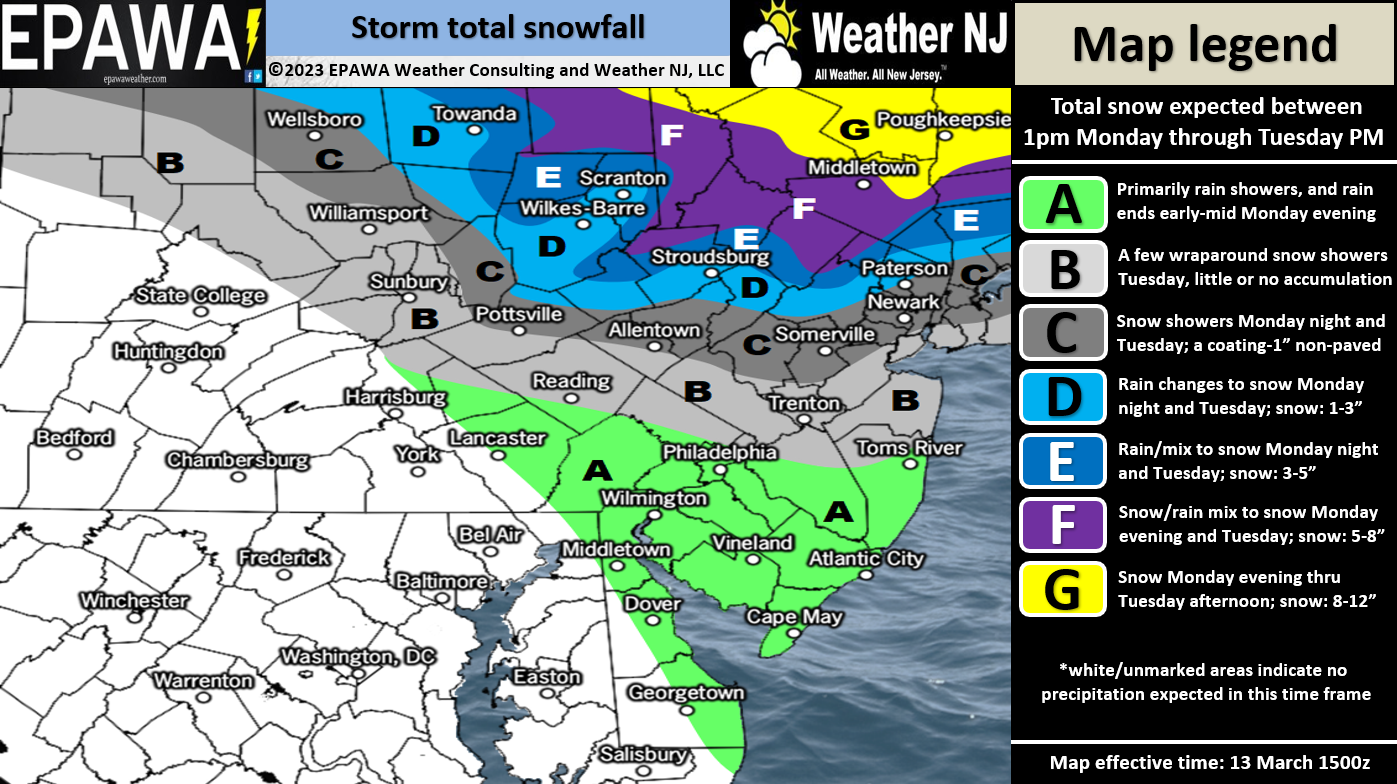
Please click snow impact map to view full-resolution!
In English: Rain has moved into NJ from the SW and a snow/rain line is establishing in NWNJ. Around 10pm or slightly later tonight, the snow/rain line will begin advancing to the SE. This will change rain to snow from NW to SE between late tonight and tomorrow morning. The heavier snow might advance from I-80 down to I-78 but that’s about it. I doubt anything more than light-to-moderate snow will occur S of I-78. Given the surface temperatures, time of year, sun angle, compaction, etc., I am not seeing anything more than a sloppy coating S of I-78 and mostly on natural surfaces only. The highest snow impact from all of this should remain N of I-80. The above snow map represents how much snow we feel will stick (a fraction)….not how much snow will actually fall (much more). So today will remain rainy for most. Tonight will start the changeover and tomorrow will be snowy. Lots of white rain S of I-78. Slushy between I-78 and I-80. Greatest wintry impacts N of I-80. It all clears out by Tuesday evening. A STRONG and FIRM WARNING for areas of NNJ that do see accumulation…this is going to be wet heart attach snow to shovel so please use caution and do not over-exert yourself. Have a great rest of your Monday and please be safe! JC
Premium Services
KABOOM Club offers inside info forecast discussion, your questions answered, and early storm impact maps (ahead of the public). At 99 cents per month, it’s an extremely feasible way to show support.
My Pocket Meteorologist (MPM), in partnership with EPAWA Weather Consulting, offers professional/commercial interests, whose businesses depend on outdoor weather conditions (snow plowing, landscaping, construction, etc.), with hyper-local text message alerts/forecasts and access to the MPM premium forum—the most comprehensive and technical forecast discussion available for PA and NJ.
Jonathan Carr (JC) is the founder and sole operator of Weather NJ, New Jersey’s largest independent weather reporting agency. Since 2010, Jonathan has provided weather safety discussion and forecasting services for New Jersey and surrounding areas through the web and social media. Originally branded as Severe NJ Weather (before 2014), Weather NJ is proud to bring you accurate and responsible forecast discussion ahead of high-stakes weather scenarios that impact this great garden state of ours. All Weather. All New Jersey.™ Be safe! JC


LOCAL FORECAST | INTERACTIVE RADAR | LATEST NJ WEATHER ALERTS | WEDDING FORECAST| PRIVACY POLICY
© Copyright 2026 Weather NJ LLC. All Rights Reserved.
Some information that can be found on our website is provided by a private weather station and is not an officially recognized station for weather reporting. Though we always strive to achieve accurate reporting for our own use, it is important that you do NOT depend on the data provided here for any purpose.
