

First Flakes Possible for Some

Discussion: A bit more rain is likely Friday night into Saturday morning but that should clear by mid-to-late Saturday morning allowing a dry Saturday afternoon-evening once things clear out. A very seasonally anomalous trough is then expected to move into the region between Sunday and Wednesday. This will be colder than “late-fall feelz” and should rather be described as that “first initial taste of winter is coming” IMO.
I expect more rain on the front of the trough arrival as a cold front pushes through on Sunday. With that said, rain could move in as early as mid-to-late morning Sunday and last into Sunday evening. I’m then watching for a secondary low to potentially spawn between late Sunday night and Monday morning. Models are very uncertain on this with wide disagreement between the Euro, GFS and Canadian. I can tell you that it’s really trying to snow though.
Given the time of year, climatology, ocean temps, etc., I doubt snow will affect any lower-elevation part of NJ. The upper elevations of NWNJ would have the best chance for first flakes of the season. I’m not seeing any kind of concentrated snowstorm, just the potential for first flakes as rain possibly transitions to such with the arrival of the anomalous cold air. And when I say anomalous cold, we’re talking about highs possibly not making it out of the 30s on Tuesday with overnight lows well into the 20s for much of NJ. Closer to the coast…highs in the mid-40s and lows in the 30s. These temps are 10-15 degrees below average and are therefore considered anomalous for this time of year. Here’s the latest Euro 500mb look for Monday morning showing the anomalous trough moving in. If that W US ridge axis was a little more neutral, we’d be looking a snow event for the E US IMO. Otherwise, the players are on the field including a solid Greenland block:
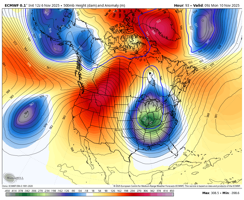
In the upper levels, the trough looks to bring an upper low through the interior E US, somewhere between Ohio (furthest N modeled) and TN (furthest S modeled). The UL is modeled at 525dam (5250 meters) above the surface on the Euro. That means that the 500mb pressure level will sink as low as 5250 meters (17224 feet) above the surface. You see, the upper jet, that rounds the bottom of a trough, acts like people in a circular pool creating a whirlpool. The center of the whirlpool lowers much like the pressure profile in the atmosphere. That’s basically how ULs form and why we measure the altitude of the fixed 500mb pressure level. The lower it is, the lower the geopotential height and the easier it is for moisture to rise and condense into precipitation. The opposite case of an upper low is an upper high, aka a ridge. Just some food for thought if you like to learn upper-level prognostication.
So, my gut is telling me, with high confidence, that we’re looking at a cold few days to start next week (Mon-Wed). I also have high confidence in precipitation, at least in the form of cold rain. Snow is lower confidence, and I am not expecting accumulations…just first possible flakes of the colder season with NWNJ favored over lower elevations of NJ. The High Point Monument area of Sussex County would have the absolute best chance for rain to change to snow on Monday. Tuesday and Wednesday look cold statewide with less chance for snow however you never know with cold air blowing over the unfrozen Great Lakes this time of year. It will certainly be cold enough for at least flakes overnight, especially away from the ocean and up in NWNJ. Perhaps flurries are not off the table with again, NWNJ favored over the lower 2/3 of Jersey.
In English: Winds came through and did their thing last night. Today is a gorgeous mid-fall day and tomorrow should be similar. A little rain Friday night into Saturday morning. A dry break Saturday afternoon through Sunday morning. Rain returns by ~noon Sunday and ushers in a very cold Monday-Wednesday for this time of year. First flakes of the colder season are possible between late Sunday night and Tuesday with NWNJ elevations favored for such. Accumulations are less probable, likely just rain changing to first flakes/flurries and again, mainly for elevations. I’ll have a detailed weekend outlook posted tomorrow. Be safe! JC
Premium Services
KABOOM Club offers ad-free content, inside info forecast discussion, your questions answered, and early storm impact maps and video releases (ahead of the public). At $1.99 per month, it’s an extremely feasible way to show additional support for Weather NJ and you can turn it on and off for however many months you wish. Think of it as a tip jar with perks. Available onFacebook or Patreon.
My Pocket Meteorologist (MPM), in partnership with EPAWA Weather Consulting, offers professional/commercial interests, whose businesses depend on outdoor weather conditions (snow plowing, landscaping, construction, etc.), with hyper-local text message alerts/forecasts from real meteorologists and access to the MPM premium forum—the most comprehensive and technical forecast discussion available for PA and NJ.
Jonathan Carr (JC) is the founder and sole operator of Weather NJ, New Jersey’s largest independent weather reporting agency. Since 2010, Jonathan has provided weather safety discussion and forecasting services for New Jersey and surrounding areas through the web and social media. Originally branded as Severe NJ Weather (before 2014), Weather NJ is proud to bring you accurate and responsible forecast discussion ahead of high-stakes weather scenarios that impact this great garden state of ours. All Weather. All New Jersey.™ Be safe! JC


LOCAL FORECAST | INTERACTIVE RADAR | LATEST NJ WEATHER ALERTS | WEDDING FORECAST| PRIVACY POLICY
© Copyright 2025 Weather NJ LLC. All Rights Reserved.
Some information that can be found on our website is provided by a private weather station and is not an officially recognized station for weather reporting. Though we always strive to achieve accurate reporting for our own use, it is important that you do NOT depend on the data provided here for any purpose.
