

First Wintry Signal to Track
Discussion: We’re going to stay in article format for this week’s outlook since a very active pattern is setting up. I’m seeing low after low through mid-November. That doesn’t necessarily mean rain or snow for NJ with each of the disturbances, but it does mean volatile swings in temperature, humidity and “some” precipitation.
First, this morning’s (Monday) rain was from the southern stream of energy that passed through the E US beneath a northern stream. The two streams did not phase or interact enough to form into a larger synoptic system. The N stream missed entirely to the N of NJ and the S stream grazed SENJ with some light rain/showers. It’s already out of here with improving conditions. Many should see sun before the now earlier sunset.
Tuesday and Wednesday look breezy and dry with afternoon highs reaching around 60 and overnight lows falling into the 30s and 40s. Tuesday night looks colder than Wednesday night. Winds should be out of the NW Tues and SW Wed.
Thursday is the next expected low which should track N of NJ through NY State and into S New England dragging a minute amount of rain through NJ on its southern side.
Friday then looks dry with a colder NW wind situation immediately following the Thursday system giving way to SW wind leading up to another low Saturday morning. Saturday’s low should track closer to NJ, maybe across/over NNJ with a more concentrated area of frontal rainfall clearing by Saturday afternoon. This should then produce a dryer Sunday which arrives at the more interesting situation early next week.
Next Monday-Friday (Nov 10-14) has strong agreement in the temperature profile. A potent late-fall trough should bring the coldest air of the season yet—bringing the first overnight freezing temperatures to many NJ locations. NWNJ elevations and a few areas away from the ocean have dropped to 32 already but next week should be more of a widespread overnight freeze situation for all except maybe the immediate coast.
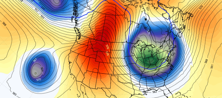
I’m seeing blocking over Greenland, a deep trough for the E US and a ridge for the W US. The only thing I don’t like about the setup, from a snow lover’s perspective, is a small upper low piercing the W US trough in the ~Tuesday timeframe. This has a downstream rippling effect of not allowing a strong surface storm to form and slow down. Instead, it kicks the E US trough some and keeps the surface low too far to the E of NJ. Otherwise, IMO, we’d be looking at a more significant snow event. Most models, however, are suggesting at least a period of rain changing over to light and disorganized snowfall which makes Nov 11 the first wintry storm signal I’ll likely track this year.
There’s a lot fighting the potential for snowfall on Nov 11. You have warm ocean temperatures, general climatology, and warmer daytime temperatures that typically produce rain over snow. You can look back at events like Halloween 2011 and the snowstorm that happened one week after Sandy in November 2012 but those were perfect pattern setups (no upper-level W US kicker systems). NWNJ elevations would have the best chance to see this. SENJ coastal regions would have the worst chance to see snow and the best chance to see rain only. You know how it goes, again…especially this early in the snow season.
With that said, I think a very light mix of rain and snow is possible early next week (around Tuesday Nov 11) and I will continue to monitor until about Thursday or Friday of this week. If it’s still showing with data agreement, we’ll move into serious tracking. If it drops off, it drops off, and onward we go later into November.
In English: A few systems will pass through NJ this week bringing periods of barely measurable rain and cool/dry conditions between. The above image shows the upper-level look of a deep and cold trough over the E US next week. This is why I’m watching early next week for a much colder drop in temperatures with the potential for at least a rain and snow mix. Snow would favor NWNJ elevations as the coastal plain will likely still be too warm for snow. Something to watch after this week’s active mid-fall pattern. Be safe! JC
Premium Services
KABOOM Club offers ad-free content, inside info forecast discussion, your questions answered, and early storm impact maps and video releases (ahead of the public). At $1.99 per month, it’s an extremely feasible way to show additional support for Weather NJ and you can turn it on and off for however many months you wish. Think of it as a tip jar with perks. Available onFacebook or Patreon.
My Pocket Meteorologist (MPM), in partnership with EPAWA Weather Consulting, offers professional/commercial interests, whose businesses depend on outdoor weather conditions (snow plowing, landscaping, construction, etc.), with hyper-local text message alerts/forecasts from real meteorologists and access to the MPM premium forum—the most comprehensive and technical forecast discussion available for PA and NJ.
Jonathan Carr (JC) is the founder and sole operator of Weather NJ, New Jersey’s largest independent weather reporting agency. Since 2010, Jonathan has provided weather safety discussion and forecasting services for New Jersey and surrounding areas through the web and social media. Originally branded as Severe NJ Weather (before 2014), Weather NJ is proud to bring you accurate and responsible forecast discussion ahead of high-stakes weather scenarios that impact this great garden state of ours. All Weather. All New Jersey.™ Be safe! JC


LOCAL FORECAST | INTERACTIVE RADAR | LATEST NJ WEATHER ALERTS | WEDDING FORECAST| PRIVACY POLICY
© Copyright 2025 Weather NJ LLC. All Rights Reserved.
Some information that can be found on our website is provided by a private weather station and is not an officially recognized station for weather reporting. Though we always strive to achieve accurate reporting for our own use, it is important that you do NOT depend on the data provided here for any purpose.
