

Friday-Saturday Winter Storm a GO!
Discussion: The jet pattern, governing the thermal gradient boundary (boundary) remains locked in a configuration across S Canada/N US from W to E, then down over the Great lakes and through the Mid-Atlantic. For this upcoming system, it will be running across Delmarva Peninsula latitude into the Atlantic Ocean. This will be the train track that our wave/low traverses from W to E. The wave will meet up with some energy just S of the Great Lakes and throw some overrunning precipitation to the NE of this boundary over NJ.
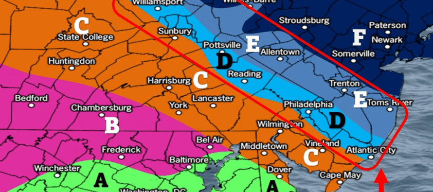
This system is very much a battleground of wintry precipitation types. Far enough NE of the boundary is easy…all snow. Far enough SW of it is also easy…mix to mostly rain. However right along the boundary contains various line of freezing locations and multiple lower levels of the atmosphere (cold at the surface, warm at 925mb, cold at 850mb, etc.). A warm nose layer or two is likely what will change areas like SWNJ/SNJ and some of CNJ to sleet at times which would erode snow accumulation amounts. There is still wide disagreement on precipitation amounts (QPF), however we have some time to iron this out as we are still 48-54 hours away from the system.
Additionally, we have a nice cold source of air from the high pressure riding just ahead of the wave to the NE of everything in Canada. This will pump cold air into the lower levels from the NE as the overrunning precipitation collides with it. Also, this system is falling overnight so we have the coldest part of the day advantage. For all of these reasons of volatility, here is our initial call for this Friday into Saturday (5pm to 5am general timing with heaviest precipitation rates occurring between 7pm and 7am). The red box indicates the highest area of uncertainty. It could literally behave like the jackpot 4–8-inch zone F or the iced-out zone C. However, we have to present a physics-based gradient with zones D and E. My gut is that there will be little of zone D and E and more of a C/F situation…all depending on where the exact boundary sets up.
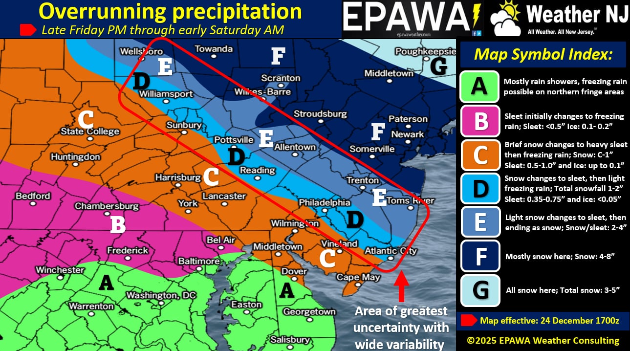
In English: Here is our first call for this Friday-Saturday (please see above wintry impact map). Today and tomorrow look great for travel…milder with little disruption during the days but still chilly nights. We then turn colder ahead of Friday evening and our system begins around 5pm Friday, ending by 5am Saturday morning. Expect the heaviest rates of precipitation, regardless of type between 7pm Friday night and 3am Saturday morning. This is the initial call. We have time to tweak a second call tomorrow (Christmas Day) and then a final third call Friday morning if need be.
Premium Services
KABOOM Club offers an ad-free environment, inside info (Above and Beyond) forecast discussion, your questions prioritized, and early storm impact maps and video releases (ahead of the public). At $1.99 per month, it’s an extremely feasible way to show additional support for Weather NJ and you can turn it on and off for however many months you wish. Think of it as a tip jar with perks. Available onFacebook or Patreon.
My Pocket Meteorologist (MPM), in partnership with EPAWA Weather Consulting, offers professional/commercial interests, whose businesses depend on outdoor weather conditions (snow plowing, landscaping, construction, etc.), with hyper-local text message alerts/forecasts from real meteorologists and access to the MPM premium forum—the most comprehensive and technical forecast discussion available for PA and NJ commercial interests.
KABOOM Shop is live if you want some KABOOM or Weather NJ Merch!
Sign up for ZoneWatch Radar and get 10% off
Jonathan Carr (JC) is the founder and sole operator of Weather NJ, New Jersey’s largest independent weather reporting agency. Since 2010, Jonathan has provided weather safety discussion and forecasting services for New Jersey and surrounding areas through the web and social media. Originally branded as Severe NJ Weather (before 2014), Weather NJ is proud to bring you accurate and responsible forecast discussion ahead of high-stakes weather scenarios that impact this great garden state of ours. All Weather. All New Jersey.™ Be safe! JC


LOCAL FORECAST | INTERACTIVE RADAR | LATEST NJ WEATHER ALERTS | WEDDING FORECAST| PRIVACY POLICY
© Copyright 2026 Weather NJ LLC. All Rights Reserved.
Some information that can be found on our website is provided by a private weather station and is not an officially recognized station for weather reporting. Though we always strive to achieve accurate reporting for our own use, it is important that you do NOT depend on the data provided here for any purpose.
