

Fringe Impact Only from Henri
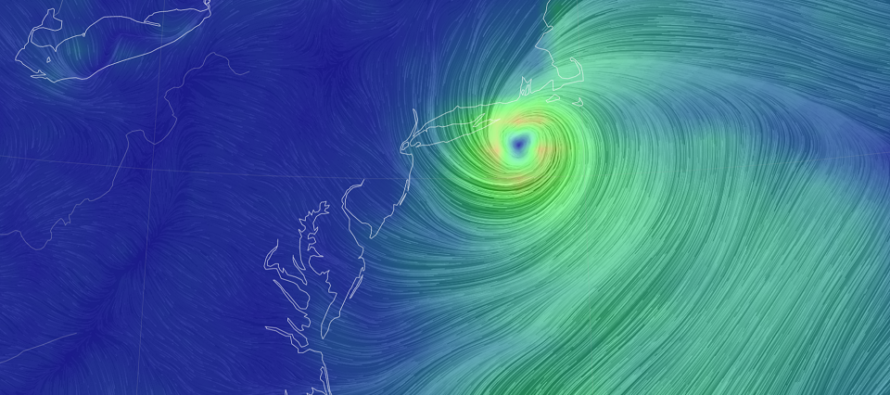
Discussion: Henri is a category 1 hurricane now at OBX latitude about 350 miles offshore. He will now take a slow and gradual turn to the N/NW towards Long Island and likely make landfall on Sunday as either a strong Tropical Storm or weak category 1 hurricane.
The last 24 hours of model guidance have been favorable for less NJ impacts from Henri. Most guidance is now favoring more of an E Long Island hit rather than a W Long Island hit. This is good news after yesterday’s nervous W trends. Also note the slightly later timing. It now appears more of a Sunday morning through Sunday night thing for NJ rather than a Saturday night (tonight) into Sunday thing. Let’s allow a small chance for some initial outer bands to drop some rain today mostly for ECNJ/SENJ. These are the main trends I’ve noticed overnight and today.
For NJ this means hardly any impact other than some rain from the far outer rain bands and outer winds. These impacts should be very manageable. NENJ and ECNJ (Monmouth and N Ocean County) are still favored to see the highest rain and wind values but again, it should not be destructive. Everywhere else in NJ will likely be asking “What storm?”
This should still be a solid coastal flooding event for E Long Island, the Long Island Sound, and some other locations further N in coastal New England. New Jersey’s coastal flooding concerns are mainly capped at minor flooding and mostly for today, not tomorrow. Come tomorrow, onshore flow will be gone and the gustiest winds will actually be out of the N/NW (when Henri pulls close enough in). Again, I only expect NENJ and ECNJ to mainly notice the winds.
Unfortunately once Henri moves away, he will not clear out the humidity with him like typical out to see hurricane misses do. Henri’s remnants are expected to push into New York State and actually generate SW flow for NJ into Monday. With the upper low still around, this should keep NJ muggy and unsettled through Monday and maybe into Tuesday morning. There is no sign of humidity relief until possibly later in the weekend. I’ll put out a weekly outlook tomorrow evening once the storm impacts are over for NJ (mostly only for NENJ/ECNJ).
In English: NJ can rest easier today. It looks like less impact is expected now and really only for NENJ and ECNJ. We’re talking about some outer rain bands and manageable winds…like what you would see for a typical nor’easter but even not as bad as that. The rain should feel soft and warm in an overall muggy environment. Impacts should slowly begin today/tonight (light winds pick up, initial outer rain bands move in off the ocean) and then peak by tomorrow afternoon. All impacts should gradually improve Sunday night into Monday despite some rain and storms (non Henri related) possible through Monday into Tuesday morning. Have a great rest of your Saturday night and please be safe! JC
Download the free Weather NJ mobile app on Apple or Android. It’s the easiest way to never miss Weather NJ content. Our premium services go even further above and beyond at the hyper-local level.
Jonathan Carr (JC) is the founder and sole operator of Weather NJ, New Jersey’s largest independent weather reporting agency. Since 2010, Jonathan has provided weather safety discussion and forecasting services for New Jersey and surrounding areas through the web and social media. Originally branded as Severe NJ Weather (before 2014), Weather NJ is proud to bring you accurate and responsible forecast discussion ahead of high-stakes weather scenarios that impact this great garden state of ours. All Weather. All New Jersey.™ Be safe! JC


LOCAL FORECAST | INTERACTIVE RADAR | LATEST NJ WEATHER ALERTS | WEDDING FORECAST| PRIVACY POLICY
© Copyright 2026 Weather NJ LLC. All Rights Reserved.
Some information that can be found on our website is provided by a private weather station and is not an officially recognized station for weather reporting. Though we always strive to achieve accurate reporting for our own use, it is important that you do NOT depend on the data provided here for any purpose.
