

Henri Could Impact New Jersey
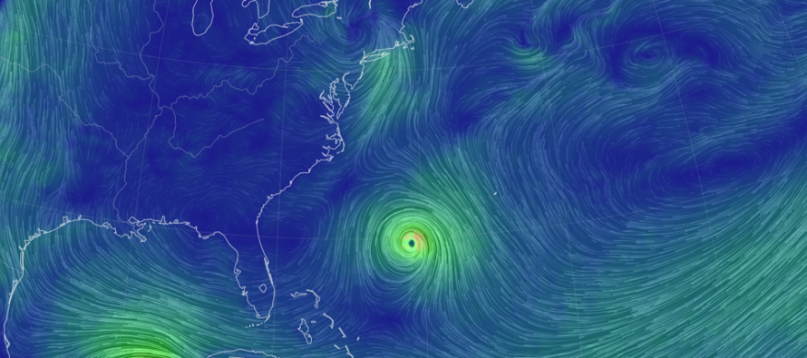
Discussion: Henri is currently a tropical storm near 30N 70W (between Bermuda and Florida – at Jacksonville, FL latitude). Henri is expected to turn to the N and follow the developing upper level ridge weakness in SE Canada on Friday. It’s likely he will be upgraded to hurricane status by Friday night.
Henri should pass about 300-400 miles offshore of OBX latitude (Saturday morning) as it follows the ridge sliding from W to E in SE Canada. At that point, the Upper-Level Low (ULL) will be developing over ~W PA which presents a double-edged sword.
If there is less ULL interaction with Henri, then the ULL SW steering currents will likely keep Henri far out to sea at NJ latitude (Saturday PM into Sunday AM) and take a track towards the tip of Cape Cod. If there is more interaction between Henri and the ULL, then a phase could tug Henri towards Long Island rather than Cape Cod. This could bring outer bands of rain and N/NW winds to NJ from Henri’s SW side of circulation. The former scenario would mean a surfer’s paradise and likely an uneventful day in NJ. The latter could mean some moderate-to-heavy rain and wind but reduced coastal flooding potential. In fact, you might see a blowout low tide from the NW winds. Something between could mean just a nuisance misty day with heavy choppy surf.
With that said I will be paying special attention to the upper-level dynamics over W PA and SE Canada this Friday-Sunday. Those are the main factors that will determine if Henri is going to hook inland (towards Long Island) or keep going towards Cape Cod. In either case, there is no model guidance nor expectation for NJ to see a Henri landfall or any of the more destructive eye wall wind areas. The ULL would have to phase extremely early. If that happens, I’ll let you know as soon as possible. But as of now the expected range of possibilities are a close graze with secondary impacts (rain, NW wind, etc.) or a slight miss out to sea.
In English: It looks like Henri could either just graze NJ with manageable rain and wind (from SW outer bands) or miss just far enough out to sea for a nicer day in NJ. That’s my current cone of uncertainty. There’s no reason to expect a primary hurricane hit in NJ (landfall). My estimated time window for when any fringe impacts could be felt in NJ is between Saturday afternoon and Sunday morning. Otherwise, if Henri stays just far enough out to sea, we’ll be feeling just a calmer day in NJ with of course, a surfer’s paradise.
Download the free Weather NJ mobile app on Apple or Android. It’s the easiest way to never miss Weather NJ content. Our premium services go even further above and beyond at the hyper-local level.
Jonathan Carr (JC) is the founder and sole operator of Weather NJ, New Jersey’s largest independent weather reporting agency. Since 2010, Jonathan has provided weather safety discussion and forecasting services for New Jersey and surrounding areas through the web and social media. Originally branded as Severe NJ Weather (before 2014), Weather NJ is proud to bring you accurate and responsible forecast discussion ahead of high-stakes weather scenarios that impact this great garden state of ours. All Weather. All New Jersey.™ Be safe! JC


LOCAL FORECAST | INTERACTIVE RADAR | LATEST NJ WEATHER ALERTS | WEDDING FORECAST| PRIVACY POLICY
© Copyright 2026 Weather NJ LLC. All Rights Reserved.
Some information that can be found on our website is provided by a private weather station and is not an officially recognized station for weather reporting. Though we always strive to achieve accurate reporting for our own use, it is important that you do NOT depend on the data provided here for any purpose.
