

Henri to Impact New Jersey
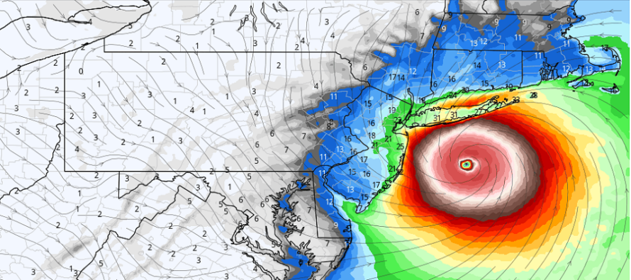
Discussion: Henri is currently at Savannah, GA latitude and about 74W longitude. He’s made the turn to the N and is now heading N/NW. I now expect him to turn a little more to the N/NE and parallel the US coast until about OBX latitude (a few hundred miles offshore).
From the OBX latitude location, it looks like Henri will want to then turn back to the N/NE and head more towards Long Island than Cape Cod. There is still no data or reason to expect a NJ landfall. I have however seen data that suggests areas like NENJ and ECNJ (Monmouth and Ocean) are now on the table for higher wind values and heavier rain. Honestly, the guidance has really took a turn for the worse for NYC and areas E of NYC, especially E Long Island and the Long Island Sound. Given the expected location of Henri’s landfall (likely as at least a category 1 hurricane) in the general central to E Long Island area, this puts the Long Island Sound and much of S coastal New England in a bad location for wind-driven storm surge. Anyone along those coasts should finish their hurricane backup planning and get ready to initialize it if the authorities call for it. Even though Henri is only expected to be a category 1 hurricane at landfall (small possibility of 2), it’s speed and location will have much more impact on wind-driven storm surge than storm intensity will…for those locations.
For New Jersey this sets up a gradient of intensity from NENJ to SWNJ. NENJ will see the most impact from Henri and SWNJ will see the least. This is kind of looking like a “what storm?” scenario for SWNJ, WCNJ, and much of SENJ. NENJ and ECNJ however need to now pay attention to how strong conditions can get on the W side of Henri when he is near Long Island. All of the ocean-facing ECNJ/SENJ coast should expect some higher flood planes over the next few days especially with the full moon nearby. However, those high tides should occur before the strongest winds and any possible rain arrive so that should keep coastal flooding in check for Saturday. Again, blow out tides during low tide are possible, especially Sunday.
By Saturday night, I expect NJ winds to change from onshore (out of E<->NE) to N or even NW as a few rain bands start to move onshore. I think the highest wind values will come from the N/NW direction which will then alleviate the coastal flooding threat. And those strongest winds should again occur mostly in NENJ and ECNJ. Current guidance would suggest sustained winds of 25-35mph with gusts to 45mph. Yesterday suggested sustained 10-15mph with gusts to 25mph. With that said, I am going to watch for additional trends in the data to suggest a further hook to the W. This will all revolve around the development of the upper low to the W of NJ. I’ve noticed that today’s guidance suggests development of the ULL more in the WV/SWPA corner rather than WPA. This is mostly likely why today’s data points to a Long Island landfall rather than a Cape Cod landfall. I’ll keep watching this tomorrow. With ULL phasing involved there are always last minute surprises possible (earlier phase, later phase, etc.). This is why Sandy (2012) hit us and Hermine (2016) missed us. So let’s stay alert but for now, no direct catastrophic impacts to NJ but a definite uptick in NENJ/ECNJ wind and rain.
In English: Henri should make landfall somewhere on Long Island, not New Jersey. If closer to W Long Island then NENJ and ECNJ (Monmouth and N Ocean) could see a period of solid, but not catastrophic, rain and wind Saturday night into Sunday morning. If closer to E Long Island than most of NJ will ask “what storm?” That’s where we’re at and I will update tomorrow. Coastal flooding concerns for NJ are non-catastrophic as well and will likely occur on Saturday before the storm gets close. There will be a full moon so expect water in the streets where water typically goes in the streets. But the water should not be into houses. Otherwise any rain and wind that NJ sees, especially NENJ and ECNJ, should occur Saturday PM into Sunday AM. Please be safe! JC
Download the free Weather NJ mobile app on Apple or Android. It’s the easiest way to never miss Weather NJ content. Our premium services go even further above and beyond at the hyper-local level.
Jonathan Carr (JC) is the founder and sole operator of Weather NJ, New Jersey’s largest independent weather reporting agency. Since 2010, Jonathan has provided weather safety discussion and forecasting services for New Jersey and surrounding areas through the web and social media. Originally branded as Severe NJ Weather (before 2014), Weather NJ is proud to bring you accurate and responsible forecast discussion ahead of high-stakes weather scenarios that impact this great garden state of ours. All Weather. All New Jersey.™ Be safe! JC


LOCAL FORECAST | INTERACTIVE RADAR | LATEST NJ WEATHER ALERTS | WEDDING FORECAST| PRIVACY POLICY
© Copyright 2026 Weather NJ LLC. All Rights Reserved.
Some information that can be found on our website is provided by a private weather station and is not an officially recognized station for weather reporting. Though we always strive to achieve accurate reporting for our own use, it is important that you do NOT depend on the data provided here for any purpose.
