


Here We Go Again

Discussion: Before we continue, I want to say that life-threatening/damaging winds from severe weather (straight-line or tornado) are a bad thing. I take my discussions very seriously when including such in my forecast, even if just a small, isolated threat of occurring within a larger less-severe stormy air mass. If there’s a possibility of severe winds and you do not receive them, that is a GOOD thing for you. Just want to make sure we are clear. If there’s anyone here who roots for severe wind damage and becomes irate if not experienced, this is not the weather page for you. Here, I communicate ranges of possibilities and if severe wind conditions are possible, they will be communicated as a possibility, not a guarantee. I can’t believe some of the things I have to say and clarify but here we are. To the majority/rest of followers, I’m sorry you had to waste your time reading this. Onto the weather discussion.
Like yesterday, today was another beautiful day for its time of season. Last night dipped into hoodie/pants territory overnight for many and today features mostly sunny blue skies with low humidity. The next two days are going to be driven by a low pressure system tracking from N of the Great Lakes down towards N of NY State and then a button hook to the NE up the E Canada.
First, a warm front attached to the low will push through from SW to NE early Tuesday AM. This could spark some showers and rumbles but nothing crazy and should be through by mid-to-late morning. We should notice the temperature and humidity increase on Tuesday once this is through.
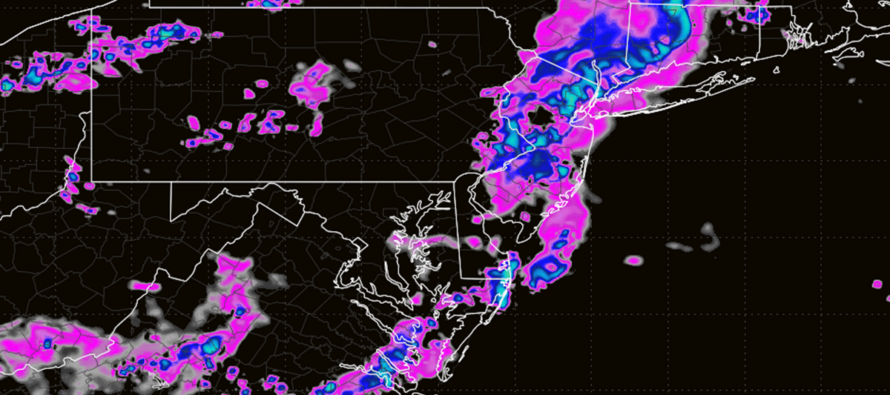
Most of Tuesday in NJ will be spent in the warm sector with a series of pre-frontal troughs and lifting mechanisms that could spark thunderstorms any time of day. The cold front will be close by but looks to linger a bit before pushing through. These storms would have the best potential to produce frequent lightning, damaging straight-line wind gusts, flash flooding rainfall, hail or a possible isolated tornado. They should come through in isolated-to-scattered clusters, and we’ll just have to play the radar. Expect the sun to poke through between storm clusters and amplify the tropical feel of the warm sector. So, on and off storms pushing through, not stormy all hours of the day. Expect this to go right into the overnight into early Wednesday AM. The one general timing trend I notice is that NNJ and CNJ could see their storm action throughout the day but SNJ sees more of an evening/nighttime storm cluster. But all hours of the day are game for the entire state.
At some point Wednesday the cold front will push all remaining storms out to sea and return us to great conditions afterward. But that might not be until later Wednesday evening due to the cold front sort of draping and taking its time to push out to sea. This will keep humidity and lifting around for much of Wednesday morning and afternoon/early-evening. Although I don’t think these storms will be as strong as Tuesday’s storms, they could still pack a punch regarding wind and rainfall. Therefore, Wednesday night should begin improvement towards dry and comfortable conditions which could last right through the weekend. Yes, a sunny, dry weekend is anticipated with lower humidity. Just need to get on the other side of the stormy Tues-Wed period.
Giving a quick side-eye to Bertha, she will not affect NJ. Bertha missed her opportunity to slide up the E US by getting trapped beneath a ridge. The steering currents involved will now take Bertha to the W towards a landfall either near NOLA or coastal TX. Bertha should then be absorbed into a cold front (same cold front spanning up into NJ) and distributed across the SE US as frontal-enhanced rainfall. These rainy remnants will likely not make it northward into the Mid-Atlantic US.
In English: Today was another great day of weather conditions and more of that is coming for Thursday-Sunday. Tuesday and Wednesday however look stormy. There should be sunny periods both days with humidity noticeably increased. But there is also the possibility for some stronger thunderstorms to push through in random linear segments throughout both days. Storms could produce damaging straight-line winds, flash flooding rainfall, hail, frequent lightning and isolated tornadoes. The tornado threat is not a guarantee and absolutely needs to be played in real-time alerting. Your range for all of this is anything from just moderate breeze with rumbles to power outages, wind/hail damage, and flash flooding. Remember, it’s a good thing if you see the former (hope for it). It’s a bad thing if you see the latter (prepare for it). Have a great rest of your Monday evening and please be safe! JC
Premium Services
KABOOM Club offers an ad-free environment, inside info (Above and Beyond) forecast discussion, your questions prioritized, and early storm impact maps and video releases (ahead of the public). At $1.99 per month, it’s an extremely feasible way to show additional support for Weather NJ and you can turn it on and off for however many months you wish. Think of it as a tip jar with perks. Available onFacebook or Patreon.
My Pocket Meteorologist (MPM), in partnership with EPAWA Weather Consulting, offers professional/commercial interests, whose businesses depend on outdoor weather conditions (snow plowing, landscaping, construction, etc.), with hyper-local text message alerts/forecasts from real meteorologists and access to the MPM premium forum—the most comprehensive and technical forecast discussion available for PA and NJ commercial interests.
KABOOM Shop is live if you want some KABOOM or Weather NJ Merch!

Jonathan Carr (JC) is the founder and sole operator of Weather NJ, New Jersey’s largest independent weather reporting agency. Since 2010, Jonathan has provided weather safety discussion and forecasting services for New Jersey and surrounding areas through the web and social media. Originally branded as Severe NJ Weather (before 2014), Weather NJ is proud to bring you accurate and responsible forecast discussion ahead of high-stakes weather scenarios that impact this great garden state of ours. All Weather. All New Jersey.™ Be safe! JC



LOCAL FORECAST | INTERACTIVE RADAR | LATEST NJ WEATHER ALERTS | WEDDING FORECAST| PRIVACY POLICY
© Copyright 2026 Weather NJ LLC. All Rights Reserved.
Some information that can be found on our website is provided by a private weather station and is not an officially recognized station for weather reporting. Though we always strive to achieve accurate reporting for our own use, it is important that you do NOT depend on the data provided here for any purpose.

