


History in the Making

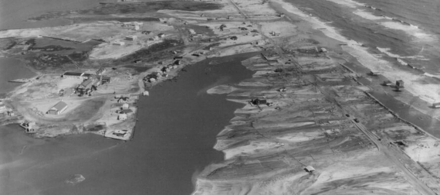
I’ve just finished making preparations at my house for what I feel will be the worst coastal storm to hit the northern east coast (specifically New Jersey) in my entire life. This feels surreal to me because I’ve only heard about these kind of storms growing up (like the great Nor’easter of 1962 pictured above). Sure I lived through Gloria, Bob, Floyd, Irene, and several others but this is different. This is going to be an extratropical hybrid storm that will not have the typical characteristics of a traditional hurricane. Where normal tropical cyclones have the highest winds wrapped around the core with weaker winds on the fringe, this storm will have equal winds throughout the entire wind field diameter. That means that if the storm makes landfall at Atlantic City then the coastal region from just north of there through Long Island, NY would experience similar impact. This storm will need its own category when we are through with it due to its hybrid qualities of both a hurricane and a nor’easter.
The worst thing I’m seeing and hearing is the National Weather Service having trouble putting the correct type of warning out there. Because the storm will transition to extratropical before it hits land, hurricane warnings cannot be issued without breaking existing NWS protocol. What this doesn’t get across is how dangerous this storm is going to be. High Wind Warnings and Flood Warnings are not taken as seriously by the general public as Hurricane Warnings. I’m getting a horrible false sense of security from most people I’ve seen in stores, especially when hearing things like, “Eh, that’s what they said about Irene and we got nothing.” Everyone needs to realize this is a completely different type of storm than Irene last year. It has the potential to perfectly phase with energy approaching from our west (a cold front). That means that this storm has the potential ability to curve into New Jersey and annihilate places like Cape May, Wildwood, Atlantic City, Long Beach Island, Seaside, Pt. Pleasant, Sandy Hook, NYC, and Long Island.
This is going to be a very bad storm both at the shore and inland. Along the ocean, there will be a 7-10 foot storm surge that will be most threatening during high tide Monday night (when there will also be a full moon). Coastal residents need to GET OUT. As far as inland residents go, power outages are expected and it might be a long time until you get it back. If you are on high ground, you can expect rain and high winds. Conditions will vary from location to location in NJ but for the most part, the entire state will be affected in some way from either rain, wind, or flooding with coastal tidal flooding easily stealing the headline.
So with all this being said, I beg you to get off the barrier islands and away from coastal regions of New Jersey for this storm. I’m talking from Cape May to Sandy Hook/Long Island. If you live near the ocean in these areas, GET OUT! IT COULD BE THE DIFFERENCE BETWEEN LIFE AND DEATH. This is not coming from a weather media outlet. This is coming from someone who grew up in the area and knows the severe weather potential very well. PLEASE LISTEN TO ME ON THIS! With so many people potentially affected, emergency personnel will have a hard time getting to you should you need their assistance due to the amount of emergencies that will arise. It might be too late to call 911 at that point, especially if your phone does not work and the ocean cuts off mainland access.
Should I loose power/communications here, I will go into mobile mode with my tablet and smartphone. As long as I can get cellular data from a tower, I can continue to post updates until my batteries run out.
Thanks for listening and considering my plea for your safety,
Jonathan Carr
SevereNJwx
Cover Image Credit: John Lloyd, Author of 18 Miles of History on Long Beach Island and Six Miles at Sea.

Jonathan Carr (JC) is the founder and sole operator of Weather NJ, New Jersey’s largest independent weather reporting agency. Since 2010, Jonathan has provided weather safety discussion and forecasting services for New Jersey and surrounding areas through the web and social media. Originally branded as Severe NJ Weather (before 2014), Weather NJ is proud to bring you accurate and responsible forecast discussion ahead of high-stakes weather scenarios that impact this great garden state of ours. All Weather. All New Jersey.™ Be safe! JC



LOCAL FORECAST | INTERACTIVE RADAR | LATEST NJ WEATHER ALERTS | WEDDING FORECAST| PRIVACY POLICY
© Copyright 2026 Weather NJ LLC. All Rights Reserved.
Some information that can be found on our website is provided by a private weather station and is not an officially recognized station for weather reporting. Though we always strive to achieve accurate reporting for our own use, it is important that you do NOT depend on the data provided here for any purpose.

