

Hot and Humid. Tracking Erin.
Discussion: Before I cover Erin’s latest update, let’s focus on New Jersey this weekend. A broad ridge across the US will build and flex for the Mid-Atlantic and NorthEast US from now until Sunday morning. A trough will then force a slow-moving cold front/stormfront through the region between Sunday afternoon and early Monday AM. This means hot and humid days today (Friday) through Sunday with elevated humidity. Temps 85-90 and dews 65-72. Not horrible but still hot and humid. Great for activities involving water (pool, boat, beach, etc.) today (Friday) and Saturday but get inside before the Sunday storms approach later in the afternoon/evening. Behind that looks like great conditions for next week…cooler and drier as Erin’s W side of broad circulation pulls cooler and drier air down from the N. Moving on to Erin…
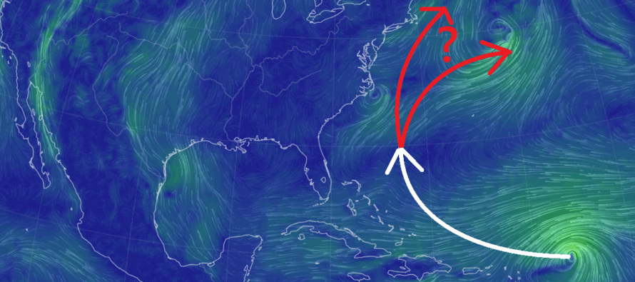
Now that we are approaching the weekend, it looks like Erin will pass far enough NE of the NE Caribbean to spare the N Lessers from a hit. They might see some fringe impacts (outer rain bands and surf) but likely not a hurricane strike. Once Erin moves past the NE Caribbean, she will likely intensify into possibly a major hurricane in the Bermuda Triangle. An area of weakness is expected to open up between the SE US and Bermuda which should allow Erin to turn and pass offshore of the E US coast (between Wed PM and Fri AM) before ultimately recurring out to sea and away from the E US via NW Atlantic trough capture. The data evidence behind this is almost unanimous support of ensemble guidance suggesting the weakness and the storm track. I do see a few outliers which could scrape OBX with some extreme western-side outer bands of rain if there’s a farther W track but that’s still a large if IMO. The most realistic track IMO is far enough out to sea for the US E coast to avoid any rain. Fringe impacts however are possible in the form of heavy surf and rip currents along the beach (very low single-digit percentage of rain drops from far W outer bands). Red flag swimming warnings are likely next week. But the atmosphere should feel quite comfortable this coming week with that N pull down of cooler and drier air, especially after this hot and humid weekend.
Forecast
Friday (Aug 15) high temperatures should reach the mid-to-upper 80s for most NJ locations, lower-80s along the coast. Skies should be mixed with more sun than clouds and a humid feel. Winds should be light out of the E/NE. Overnight lows should fall to around 70 statewide.
Saturday (Aug 16) high temperatures should reach the mid-to-upper 80s for most NJ locations, near-80 along the coast. Skies should be mostly sunny with a humid feel. Probably the best day for summer outdoor activities, especially boat, beach, pool, etc. Winds should be light out of the E/SE. Overnight lows should fall to the mid-to-upper 60s statewide, closer to 70 along the coast.
Sunday (Aug 17) high temperatures should reach the low-to-mid 90s for most NJ locations, mid-80s along the coast. The hottest and most humid-feeling day of the weekend. Skies should start mixed with sun and clouds. Thunderstorms are possible for PM hours starting in the afternoon. Winds should be light out of the SW. Overnight lows should fall to the 65-70 range NNJ to SNJ.
An early look at next week (Aug 18-22) indicates cooler temperatures. Erin is assumed to be somewhere offshore which will put NJ on the W side of broad W Atlantic Ocean circulation, pulling cooler and drier air down from the N. Temps are looking mid-70s to near-80 with lower humidity. Let’s revisit in a few days. Also I might have an article or two out about Erin’s status but for now, likely a miss out to sea with fringe coastal impacts (heavy surf, rip currents, etc.) Have a great weekend and please be safe! JC
Premium Services
KABOOM Club offers ad-free content, inside info forecast discussion, your questions answered, and early storm impact maps and video releases (ahead of the public). At two bucks per month, it’s an extremely feasible way to show additional support for Weather NJ. Think of it as a tip jar with perks. Available onFacebook or Patreon.
My Pocket Meteorologist (MPM), in partnership with EPAWA Weather Consulting, offers professional/commercial interests, whose businesses depend on outdoor weather conditions (snow plowing, landscaping, construction, etc.), with hyper-local text message alerts/forecasts and access to the MPM premium forum—the most comprehensive and technical forecast discussion available for PA and NJ.
Jonathan Carr (JC) is the founder and sole operator of Weather NJ, New Jersey’s largest independent weather reporting agency. Since 2010, Jonathan has provided weather safety discussion and forecasting services for New Jersey and surrounding areas through the web and social media. Originally branded as Severe NJ Weather (before 2014), Weather NJ is proud to bring you accurate and responsible forecast discussion ahead of high-stakes weather scenarios that impact this great garden state of ours. All Weather. All New Jersey.™ Be safe! JC


LOCAL FORECAST | INTERACTIVE RADAR | LATEST NJ WEATHER ALERTS | WEDDING FORECAST| PRIVACY POLICY
© Copyright 2025 Weather NJ LLC. All Rights Reserved.
Some information that can be found on our website is provided by a private weather station and is not an officially recognized station for weather reporting. Though we always strive to achieve accurate reporting for our own use, it is important that you do NOT depend on the data provided here for any purpose.
