

How much will it snow this Friday?
Discussion: A clear and cold day today is followed by a colder night. None of NJ will make it above freezing today and tonight temps should range from 10-25 from NNJ elevations to the most extreme SENJ coast (most of NJ down into teens – NWNJ possibly just down into single digits). Thursday temps then rise slightly to about the 30-40 range (NWNJ to SENJ) before falling back below freezing overnight as the snow arrives.
Initially, we have some energy tracking W to E across the N US. We also have a surface low that will race out into the Atlantic Ocean, ahead of the N energy. This should all happen Thursday night which should allow at least snow showers to move in by or just after midnight Thursday night. Then it gets interesting as an InVerted Trough forms offshore as the ocean low reaches back to the N stream energy in the form of a lateral W-reaching trough, aka an inverted trough.
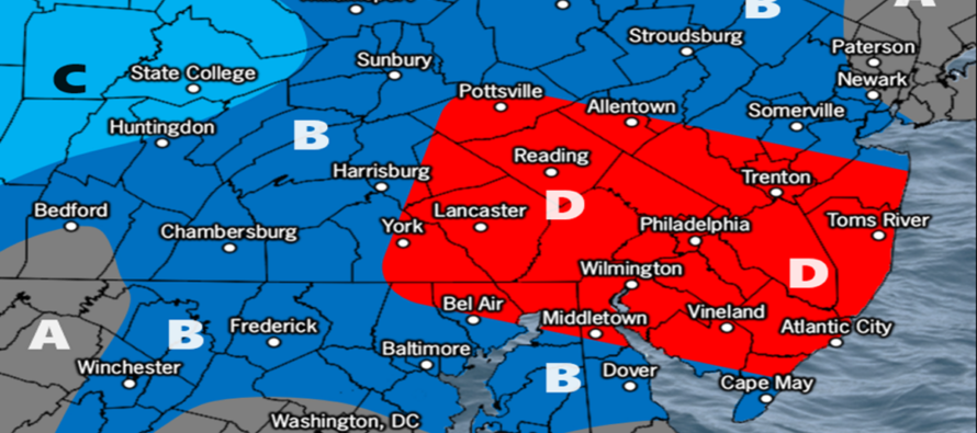
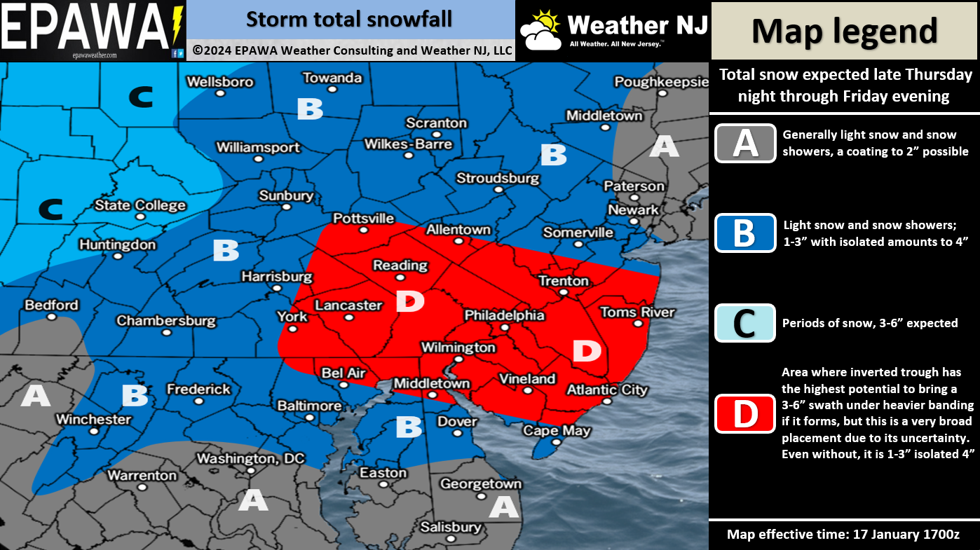
IVTs delivery a precise strike of heavier snow that usually only spans about 50-100 miles from N to S. This area is associated with the greatest frontogenic forcing and general moist lifting in the atmosphere. Areas just outside of the IVT axis (to the N and S of) then see a lesser outcome due to seeing the reciprocation of the IVT lifting. Instead, neighboring and adjacent areas of the IVT see drier sinking air known as subsidence which lowers snow totals. So all models are unanimous in seeing the IVT for Friday, however they are jumping around a bit. Our map below illustrates where (in red – Zone D) we think the axis of the IVT will hit. Zone B represents the adjacent areas that should see less snow. And note that we have even less for extreme NENJ (Zone A). The general axis of the IVT will be from W/NW to E/SE which takes extreme NENJ and S Delmarva even further out of the expected snow outcome. We also may need to make a small tweak tomorrow along the extreme SENJ area (Cape May to Atlantic City – immediate coasts) to allow for some lower temps near the very warm Atlantic Ocean. More guidance is needed.
Timing: Light snow showers could break out before midnight Thursday night but the IVT will likely not start until a few hours after midnight. Everyone should then expect an all-day lighter snow throughout Friday (heavier in the IVT area) before wrapping up Friday evening.
In English: More snow is coming. Like the other day, it’s not a big snowstorm. It’s a light event region-wide. However in the IVT zone (see above), a 3-6 inch snowfall is more likely. It all happens between late Thursday night (tomorrow night) and Friday evening, with most snow falling between sunrise and afternoon on Friday. Conditions then clear for a very cold rest of the weekend (Saturday the coldest day/night). Then the January thaw is expected to start next week. There will be more snow chances possibly at the tail-end of January but if not then in February for sure. The colder pattern is set to reload after the January thaw. We will provide an updated map and forecast tomorrow as needed. Given the nature of an IVT I bet there will be changes. Have a great rest of your Wednesday. Please stay warm tonight and be safe! JC
Premium Services
KABOOM Club offers inside info forecast discussion, your questions answered, and early storm impact maps (ahead of the public). At a buck per month, it’s an extremely feasible way to show support.
My Pocket Meteorologist (MPM), in partnership with EPAWA Weather Consulting, offers professional/commercial interests, whose businesses depend on outdoor weather conditions (snow plowing, landscaping, construction, etc.), with hyper-local text message alerts/forecasts and access to the MPM premium forum—the most comprehensive and technical forecast discussion available for PA and NJ.
Get your KABOOM Inside Out pajamas and more at the KABOOM shop!
Jonathan Carr (JC) is the founder and sole operator of Weather NJ, New Jersey’s largest independent weather reporting agency. Since 2010, Jonathan has provided weather safety discussion and forecasting services for New Jersey and surrounding areas through the web and social media. Originally branded as Severe NJ Weather (before 2014), Weather NJ is proud to bring you accurate and responsible forecast discussion ahead of high-stakes weather scenarios that impact this great garden state of ours. All Weather. All New Jersey.™ Be safe! JC


LOCAL FORECAST | INTERACTIVE RADAR | LATEST NJ WEATHER ALERTS | WEDDING FORECAST| PRIVACY POLICY
© Copyright 2026 Weather NJ LLC. All Rights Reserved.
Some information that can be found on our website is provided by a private weather station and is not an officially recognized station for weather reporting. Though we always strive to achieve accurate reporting for our own use, it is important that you do NOT depend on the data provided here for any purpose.
