

How much will it snow this weekend?
Discussion: Today is all about the snow map. It will drive this discussion, layout our first forecast for this system, and anchor the embedded video below. To quickly summarize, El Nino has transitioned from an east based setup (ENSO regions 1+2) to a distributed setup (ENSO regions 1-4). Instead of the warmest Sea Surface Temps (SST) being located close to NW S America, they are now evenly warm across the entire ENSO region that spans along the equator from S America to the International Date Line. The east-based setup produces a typical rainy December and now we are finally transitioning into a colder pattern. After this storm, there should be some brief ups and downs but the second 2/3 of January is starting to look cold due to Polar Vortex and Arctic forces set to come alive. The system this weekend is a quick moving low that came off the Pacific and is crossing the US (from W to E). It will briefly pass through a location off the Jersey coast where it should dump snow on NNJ, rain on SNJ, and a mix between. Let’s dive into the forecast. First, our impact map and then a breakdown of each region by precip type and amount and then other storm impacts.
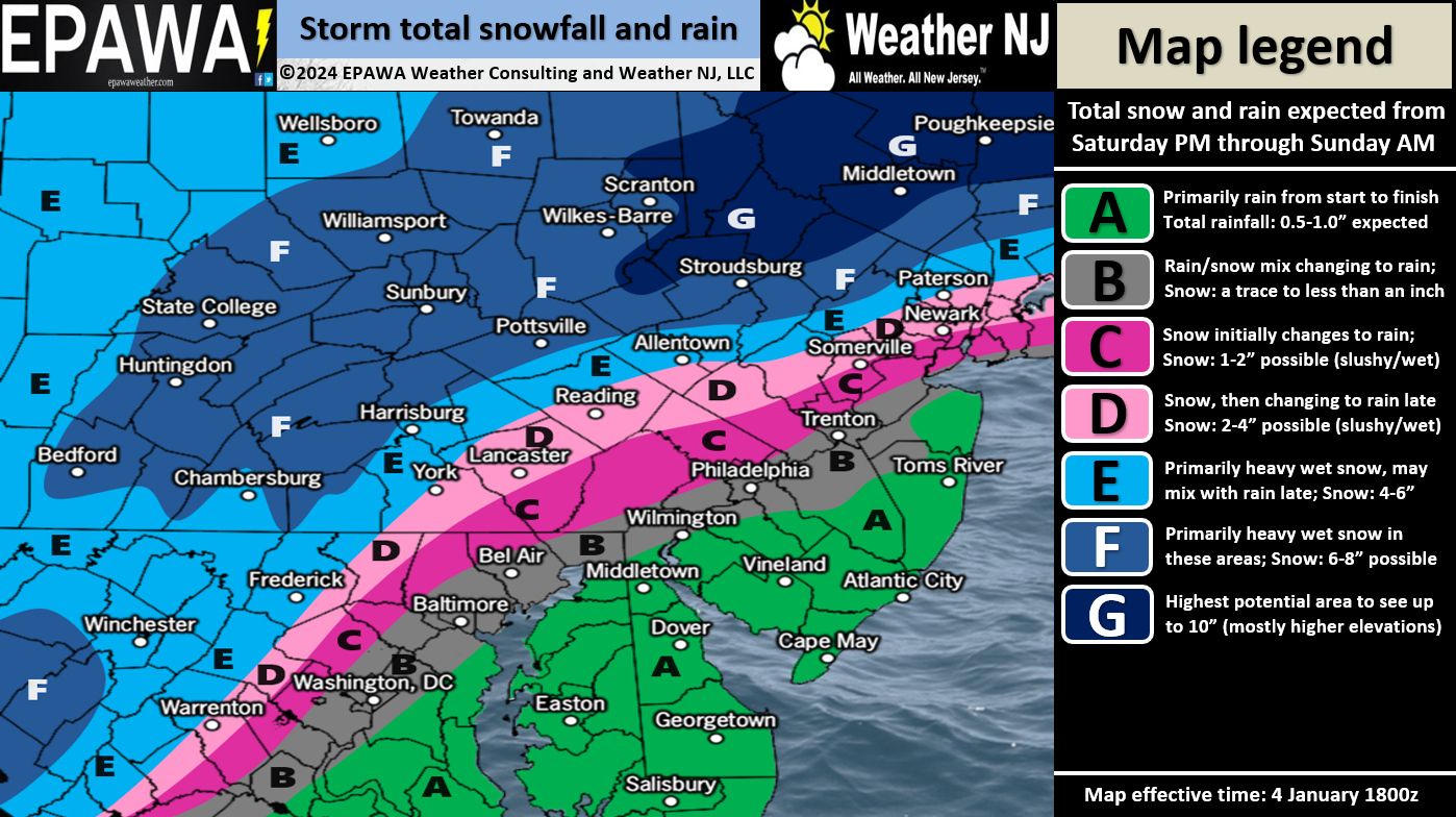
Zone A: Expect mostly rain with little-to-no accumulation of snow. Perhaps some of Zone A (closer to zone B) ends in flurries but will likely be “too little too late” after the meat and potatoes of the storm occurs wet, above freezing, and windy.
Zone B: This region should behave similar to zone A in the sense of mostly rain. However, snow could mix in at times (likely start and end of storm) and produce a trace coating up to an inch of snow when all is said and done. That would likely happen on natural/grassy/cold surfaces only and likely closer to zone C – away from zone A. Not seeing much street impact, especially highways, other than traditional “slippery when wet” rain stuff.
Zone C: Expect this zone to be the most uncertain zone of the forecast. Any slight wavering of the low track could mean the difference between zone C behaving like zone D or zone B. For that reason, we’re going conservative in zone C. We are not prepared to say all rain but more likely a wet/slushy snow accumulation for anything that does stick. Believe me, I am all for this zone performing colder and like zone D. But I am not going to BS you, this region could go either way with regard to how much rain sneaks in and knocks any snow totals down.
Zone D: This zone has a good chance for light snow accumulations that are less slushy than zone C. This D zone is NW of the piedmont fall zone line and has done very well snow-wise for almost a week of model consistency. I am personally leaning towards the higher range of the suggested 2-4 outcome.
Zone E: This zone is even more secure than zone D with regard to colder air temps and precipitation type. This area should see all snow but likely a heavy wet snow that will like to compact. We believe 4-6 is a good conservative range for this zone E.
Zone F: Same as Zone E but a few more inches. 6-8 a good conservative call for now of heavy wet snow.
Zone G: This zone represents the highest elevations of NWNJ/NNJ (includes High Point Monument). This zone often behaves more like the Poconos or even Catskills and should be inside the heaviest jackpot zone of the entire system. For this reason, we believe that up to 10 inches of snow are possible in this zone G.
Timing: First flakes/drops should happen between 4-7pm Saturday evening. Precipitation should fill in from SW to NE and eventually cover all of NJ by 10pm with either snow or rain (likely divided near 95).
Rainfall: For the SE areas that see all or mostly rain, you’re looking at a range of .75-1.25 inches of rainfall over the entire storm system.
Winds: Immediate coastal areas of zone A (ECNJ and SENJ) should expect wind gusts off the ocean in excess of 40 mph during peak storm conditions early Sunday morning. Winds should gradually build Saturday afternoon into evening (off the ocean) and then crank hardest between 10pm and 9am. Winds should then subside but remain stiff out of the NW for the rest of Sunday.
Coastal Flooding: Minor coastal flooding (for immediate ECNJ and SENJ coastal locations) is possible for the high tide occurring late Saturday PM through early Sunday AM (when wind-driven storm surge times with astronomical high tide up and down the Jersey coast). The rainfall should struggle to drain. Luckily the moon is in a waxing gibbous phase or we would be looking at even higher levels of coastal flooding.
Wildcard Possibilities: Today’s GFS and Euro both showed a stronger snowy finish for NNJ, and even some of CNJ, in the form of a Cold Conveyor Belt (CCB). This would mean snowfall wraps up closer to noon instead of earlier Sunday morning with a finishing blitz (bonus few inches of snow) and this could push down to 95 since winds will be out of the N at that time. This would mean that zones E, D, and possibly some of C behave more like zone F. It could mean zone G KABOOM’s. In the other direction of wildcard, the low could track and tuck closer to the coast to generate a warmer solution than our map above but likely not much less. Right now the models are leaning more towards a snowier wildcard than a warmer one. The latest EPS is significantly colder and snowier to finish. But we believe our map and forecast above are a good place to start this forecast. We will adjust tomorrow if needed after reviewing the latest model data and live observations across the US.
In English: Other than the intro paragraph, the above snow/impact map and forecast description by zone and hazard are straightforward and mostly in English. I recommend seeing the video embedded above for short video I made about the snowmap. It’s not a major snowstorm. It’s not a KABOOM. But it’s something wintry for at least NWNJ/NNJ and there is more to come as January looks to turn much colder in about a week or so. Be safe! JC
Premium Services
KABOOM Club offers inside info forecast discussion, your questions answered, and early storm impact maps (ahead of the public). At a buck per month, it’s an extremely feasible way to show support.
My Pocket Meteorologist (MPM), in partnership with EPAWA Weather Consulting, offers professional/commercial interests, whose businesses depend on outdoor weather conditions (snow plowing, landscaping, construction, etc.), with hyper-local text message alerts/forecasts and access to the MPM premium forum—the most comprehensive and technical forecast discussion available for PA and NJ.
Get your KABOOM Inside Out pajamas and more at the KABOOM shop!
Jonathan Carr (JC) is the founder and sole operator of Weather NJ, New Jersey’s largest independent weather reporting agency. Since 2010, Jonathan has provided weather safety discussion and forecasting services for New Jersey and surrounding areas through the web and social media. Originally branded as Severe NJ Weather (before 2014), Weather NJ is proud to bring you accurate and responsible forecast discussion ahead of high-stakes weather scenarios that impact this great garden state of ours. All Weather. All New Jersey.™ Be safe! JC


LOCAL FORECAST | INTERACTIVE RADAR | LATEST NJ WEATHER ALERTS | WEDDING FORECAST| PRIVACY POLICY
© Copyright 2026 Weather NJ LLC. All Rights Reserved.
Some information that can be found on our website is provided by a private weather station and is not an officially recognized station for weather reporting. Though we always strive to achieve accurate reporting for our own use, it is important that you do NOT depend on the data provided here for any purpose.
