

Hurricane Lee New Jersey Discussion
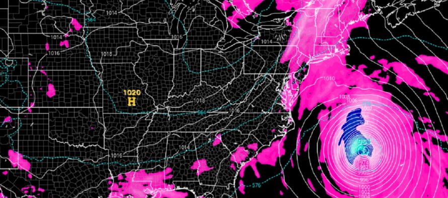
Discussion: Before we get into Hurricane Lee, I want to address the rest of today and the next few days leading into the weekend. There are currently (as of Thursday Sept 7 – 4:15pm) storms firing in EPA and MD however they look to take a N/NE track towards NY State with the general steering current of the Bermuda high/W Atlantic ridge. It might only be NWNJ that gets clipped this afternoon/evening. Just to play it safe, let’s just say that scattered showers and thunderstorms are possible for NJ this afternoon/evening with areas NW of I-95/NJTP much more favored than SE of I-95/NJTP. Friday looks spotty at best with isolated-to-scattered showers and thunderstorms possible, not a widespread washout. And honestly that trend should continue through the rest of the weekend. I’ll have a detailed weekend outlook posted tomorrow.
Hurricane Lee has strengthened significantly over the past two days. When we last discussed on Tuesday, it was still a tropical depression. As of today’s (Thursday) 11am update from the National Hurricane Center, Lee is a strong category 2 hurricane rapidly approaching major criteria (category 3 or greater). I would be surprised if Lee does not become a major category 3 by this evening. The following image represents the NHC’s latest graphical advisory update:
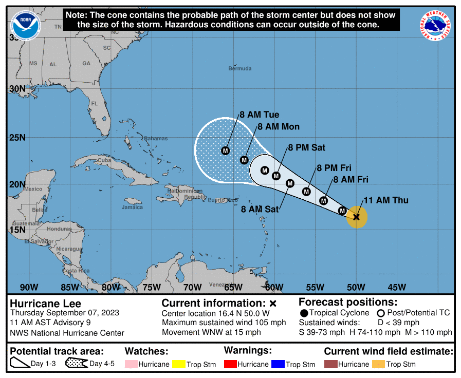
The most obvious and immediate forecast of high confidence is that Lee will continue to move W/NW (towards the SE US coast) very slowly under a ridge that will meander to the E and then NE of Bermuda. It might be another 6 days or longer before Lee nears/passes Bermuda longitude around Miami, FL latitude. During this W/NW creep, it will likely become a major category hurricane (cat 4 likely cat 5 not off the table). It’s a warm water low-shear environment under that ridge, so not much to inhibit development over the next few days. From that point and beyond lies the uncertainty. At this point all we can do is try to estimate steering currents from long-range model projections of the upper levels.
Right now, long-range model guidance has a trough pushing into/through the E US mid-next week. The front side of that trough features E/NE and or NE (depending on trough axis) steering currents which meteorologically/theoretically would turn Lee from the W/NW heading to the at least the N, away from the SE and Mid-Atlantic US next Wednesday-Thursday (Sept 13-14) with Lee likely passing offshore Thursday-Friday (Sept 14-15). Such a solution would spare NJ from the core destructive winds and dangerous storm surge however secondary impacts would be expected in the form of dangerous rip currents, enhanced surf, and at least minor levels of coastal flooding over a few tidal cycles. It would also be reasonable to assume some frontal rain enhancement for NJ due to the interaction of Lee and the frontal boundary. We’re going to have to get to the end of this weekend to estimate NJ impacts more precisely. But currently leaning away from a direct hit and thinking more of a near-pass for NJ with variable levels of fringe impacts depending on Lee’s proximity to the US east coast. We will also likely have another storm out there (“I don’t know, Margot”) which could provide additional steering current influence if close enough. I will revisit tomorrow to make sure the modeled steering current configurations are holding.
The most uncertain part of the forecast is once Lee is at or just N of NJ latitude after passing near/offshore of NJ. There is a modeled upper low near the Great Lakes that could tug Lee into sustaining a N track into Extreme E New England/Nova Scotia rather than a clean curve that misses all land. This is an outlying solution at this point but if realized, would mean NJ sees stronger secondary impacts (Thursday-Friday) but still not primary impacts. It would likely mean a direct strike into Nova Scotia with Cape Cod and the Gulf of Maine seeing a rocky Friday-Saturday just inside the W outer bands of the storm. At that latitude we’ll likely be seeing signs of subtropical or extra-tropical transition as waters are cooler and mid-latitude westerlies take control.
So to sum up the discussion, there are 3 logical separations IMO. The first part has the highest certainty which is a 5-7 day creep W/NW of where it is now while intensifying. We know this from live observations of the establishing ridge which will walk it between Bermuda and the Lesser Antilles. The second part then begins around Wed-Thurs next week. This part has lower confidence/more uncertainty but solid model support for Lee to turn to the N and miss the SE US and Mid-Atlantic US. This is assuming the NE steering currents will be in place from an approaching trough. A late trough could mean a track closer to NJ which is why this second part remains slightly uncertain. But for now the best data supports a turn northward. The third and most uncertain part is where Lee goes after NJ latitude. Does it stay away from all land with a complete recurve back to the E (currently most likely – assisted by mid-latitude westerlies). Or does it continue northward movement into E New England/Nova Scotia? We know part 1 now. We will be much more sure of part 2 by the end of this weekend. Part 3 is not worth investing any certainty into until we are into part 2 and have a real-time eye/handle on the approaching trough.
In English: Expect possible scattered showers and thunderstorms to scrape areas NW of I-95/NJTP this evening (extreme NWNJ most favored). SENJ is least favored but cannot completely rule out isolated activity given the Florida-like dew environment. The heat sticks around through Friday, takes a step down Saturday and Sunday, then another step down to start next week. All while scattered showers and thunderstorms are possible during the weekend (not a washout). Hurricane Lee has a long way to go before it would threaten NJ with likely secondary impacts, less likely primary impacts. But we’re not there yet with any certainties, just following some long-range data trends. There is no reason to be complacent nor to panic yet, just know that it’s out there. I am closely monitoring and will have a better idea of NJ impacts by end of weekend. Weekend outlook will be out tomorrow and I will update on Lee as well. Be safe! JC
Premium Services
KABOOM Club offers inside info forecast discussion, your questions answered, and early storm impact maps (ahead of the public). At 99 cents per month, it’s an extremely feasible way to show support.
My Pocket Meteorologist (MPM), in partnership with EPAWA Weather Consulting, offers professional/commercial interests, whose businesses depend on outdoor weather conditions (snow plowing, landscaping, construction, etc.), with hyper-local text message alerts/forecasts and access to the MPM premium forum—the most comprehensive and technical forecast discussion available for PA and NJ.
Jonathan Carr (JC) is the founder and sole operator of Weather NJ, New Jersey’s largest independent weather reporting agency. Since 2010, Jonathan has provided weather safety discussion and forecasting services for New Jersey and surrounding areas through the web and social media. Originally branded as Severe NJ Weather (before 2014), Weather NJ is proud to bring you accurate and responsible forecast discussion ahead of high-stakes weather scenarios that impact this great garden state of ours. All Weather. All New Jersey.™ Be safe! JC


LOCAL FORECAST | INTERACTIVE RADAR | LATEST NJ WEATHER ALERTS | WEDDING FORECAST| PRIVACY POLICY
© Copyright 2026 Weather NJ LLC. All Rights Reserved.
Some information that can be found on our website is provided by a private weather station and is not an officially recognized station for weather reporting. Though we always strive to achieve accurate reporting for our own use, it is important that you do NOT depend on the data provided here for any purpose.
