

Ian to Bring Impacts up the East Coast
Discussion: Ian made landfall yesterday in the Punta Gorda area of Florida as a category 4 major hurricane. You’ve probably seen images and footage of such. Pretty much a worst-case scenario for the central western FL coast. Overnight, Ian crossed the State of Florida from SW to NE, passing just S of Orlando and emerging over the Atlantic Ocean this morning between Daytona and Cape Canaveral. This land stretch has weakened Ian all the way down to strong tropical storm criteria. With that said, Ian is back over water and is expected to re-intensify back into at least a category 1 hurricane again before making a second landfall likely along the SC coast Friday morning.
So where does it go from there? Likely further to the NW into SC, W NC, and ultimately W VA by Saturday morning. The reason for this NW movement is because Ian is now stuck under the approaching ridge and is to the W of the high pressure crossing through the NE US. Ian’s remnant core energy will ultimately come to a stop when the ridge flexes to its N. With Ian transitioning to more of a mid-latitude cyclone, via extratropical transition, an extended frontal boundary will continue to extend up the east coast despite Ian’s center point coming to a stall over ~W VA. This frontal feature will likely push rain into New Jersey starting Saturday morning and lasting for much of the weekend.
Sunday looks a little less rainy but still on-and-off periods of lighter rain, maybe some clear breaks. Saturday seems more like a washout day. It’s the coastal flooding that I am starting to become concerned about due to a prolonged period of onshore flow starting late tonight (Thursday night) and lasting possibly into Tuesday. The high tides occurring Saturday night and Sunday would likely produce the highest water levels.
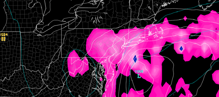
Once the Saturday-Sunday rain and wind are through, the tail side of the entire system (Ian’s original core) is modeled to spawn another coastal system for ECNJ/SNJ in the Monday-Tuesday period (see cover image above from Euro). The coastal wouldn’t be that strong but it would help extend the period of onshore flow possibly another day into Wednesday.
In English: Hurricane Ian delivered a crippling blow to Florida yesterday/overnight and is now turning up the east coast. It will head inland towards W VA and throw rain and wind northward into New Jersey Saturday-Sunday. Saturday looking like a washout. Sunday more of a nuisance. Then more rain and wind are possible Monday-Tuesday from the back end of it all. So, on-and-off rain, moderate winds, and coastal flooding all possible between Saturday morning and at least Tuesday morning. I’ll go into more detail tomorrow for the weekend outlook. Have a great rest of your Thursday and please be safe! JC
Premium Services
KABOOM Club offers inside info forecast discussion, your questions answered, and early storm impact maps (ahead of the public). At a buck per month, it’s an extremely feasible way to show support.
My Pocket Meteorologist (MPM), in partnership with EPAWA Weather Consulting, offers professional/commercial interests, whose businesses depend on outdoor weather conditions (snow plowing, landscaping, construction, etc.), with hyper-local text message alerts/forecasts and access to the MPM premium forum—the most comprehensive and technical forecast discussion available for PA and NJ.
Jonathan Carr (JC) is the founder and sole operator of Weather NJ, New Jersey’s largest independent weather reporting agency. Since 2010, Jonathan has provided weather safety discussion and forecasting services for New Jersey and surrounding areas through the web and social media. Originally branded as Severe NJ Weather (before 2014), Weather NJ is proud to bring you accurate and responsible forecast discussion ahead of high-stakes weather scenarios that impact this great garden state of ours. All Weather. All New Jersey.™ Be safe! JC


LOCAL FORECAST | INTERACTIVE RADAR | LATEST NJ WEATHER ALERTS | WEDDING FORECAST| PRIVACY POLICY
© Copyright 2026 Weather NJ LLC. All Rights Reserved.
Some information that can be found on our website is provided by a private weather station and is not an officially recognized station for weather reporting. Though we always strive to achieve accurate reporting for our own use, it is important that you do NOT depend on the data provided here for any purpose.
