

Ian to Strike Florida Today. What it means for NJ.
Discussion: Ian is a major category 4 hurricane (just short of category 5) an will likely make landfall on the central W FL coast this afternoon-evening. It looks like the area between Sarasota/Tampa and Sanibel Island represent the location of landfall however regardless of the exact location, that entire strip is subject to life-threatening destructive wind and storm surge forces.
Between now and Friday, Ian is expected to take a slow and painful track across Florida from S/SW to N/NE. It could very well cross through the Orlando area on Thursday and emerge over the Atlantic Ocean near Daytona, FL. The reason for this S/SW to N/NE track is because Ian wants to follow the departing trough into the N Atlantic Ocean (the missed trough connection).
Once out over the Atlantic, most guidance and observations suggest Ian heading back towards the east coast, making a second landfall somewhere in the SC/GA coast on Friday. At this point Ian will have turned to the NW. The reason for this expected change in movement (SE to NW) will be the approaching ridge and mostly the ridge-leading high pressure return flow.
After the second landfall in the SC/GA area, Ian will continue to weaken and change into a mid-latitude cyclone via extratropical transition. A ridge is expected to flex just over/to the N of the Great Lakes. This should halt Ian’s remnants in place around the Saturday-Sunday period and really take a toll on Ian’s remaining strength as a cyclone. This mechanism should then allow rain to move up the east coast towards New Jersey as more of a frontal system rather than a cyclonic instance. The ridge block could then transfer the remnant low (whatever is left of it) towards the Mid-Atlantic US coast and ultimately spare NJ from any cyclonic or convective impacts synoptically. Some rainfall would in-theory could still make it into at least SNJ/CNJ this Saturday-Sunday before everything clears out to sea Monday-Tuesday AM. So as far as rainfall, I am not that worried. NJ needs it.
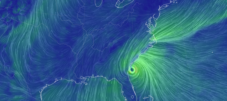
It’s the coastal flooding profile that continues to bug me. The high pressure to our N will be spinning anti-cyclonically (clockwise). Ian’s remnants will be spinning cyclonically (counter-clockwise). Both features will force wind into NJ off the ocean…like a two-wheel baseball pitching machine. This onshore flow could begin as early as Thursday night and last through possibly Tuesday morning. That means at least 8 high tides occurring during prolonged onshore flow. With that said, I see at least a minor coastal flooding concern, possibly moderate, for Raritan Bay, coastal ECNJ/SENJ, and those around the Delaware Bay and ocean-facing Delaware coasts. By tomorrow, tidal guidance should start to show us the extent of coastal flooding this weekend.
In English: Hurricane Ian is a strong category 4 storm and will make landfall today on the W FL coast (likely between Tampa and Sanibel Island). It should then cross Florida on Thursday (over Orlando) and eject into the Atlantic Ocean Friday (near Daytona) before heading back into SC/GA (another possible landfall) Friday night. From there, Ian should weaken in the SE US to just rainy remnants and moderate winds. NJ could still see some of this rainfall in the Saturday-Monday period but the biggest concern would be coastal flooding for ECNJ/SENJ between Friday and Tuesday due to prolonged onshore flow.
Premium Services
KABOOM Club offers inside info forecast discussion, your questions answered, and early storm impact maps (ahead of the public). At a buck per month, it’s an extremely feasible way to show support.
My Pocket Meteorologist (MPM), in partnership with EPAWA Weather Consulting, offers professional/commercial interests, whose businesses depend on outdoor weather conditions (snow plowing, landscaping, construction, etc.), with hyper-local text message alerts/forecasts and access to the MPM premium forum—the most comprehensive and technical forecast discussion available for PA and NJ.
Jonathan Carr (JC) is the founder and sole operator of Weather NJ, New Jersey’s largest independent weather reporting agency. Since 2010, Jonathan has provided weather safety discussion and forecasting services for New Jersey and surrounding areas through the web and social media. Originally branded as Severe NJ Weather (before 2014), Weather NJ is proud to bring you accurate and responsible forecast discussion ahead of high-stakes weather scenarios that impact this great garden state of ours. All Weather. All New Jersey.™ Be safe! JC


LOCAL FORECAST | INTERACTIVE RADAR | LATEST NJ WEATHER ALERTS | WEDDING FORECAST| PRIVACY POLICY
© Copyright 2026 Weather NJ LLC. All Rights Reserved.
Some information that can be found on our website is provided by a private weather station and is not an officially recognized station for weather reporting. Though we always strive to achieve accurate reporting for our own use, it is important that you do NOT depend on the data provided here for any purpose.
