

Ian’s Remnants Approaching New Jersey

Discussion: This weekend’s outlook is going to stay in the form of a discussion article since conditions will be mostly determined by Ian’s remnants. Ian made a second landfall today in coastal SC (N of Charlston S of Myrtle Beach) as a category 1 hurricane. That area appears lowly inhabited with mostly natural boundary islands and estuaries. That should help but still a lot of flooding rain and tropical storm force winds to deal with. And as always, the general tornado threat that exists in the NE quadrant of a tropical system over land.
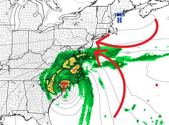
Ian is no doubt in extratropical transition becoming a mid-latitude cyclone. We’re starting to see the ocean fetch extending to the E/NE, a warm sector and cold front to the S/SE, etc. From here, it looks like Ian wants to occlude to the W off the upper-jet (towards WV) as a piece of energy breaks off and slides up the coast with the upper jet. This is the shatter result of the high pressure/approaching ridge punch from the N. At the lower levels this means two separate events for New jersey.
First would be rain associated with the piece that breaks off. This is approaching now from the S (already into Cape May). Rain should spread into the rest of NJ from S to N this evening overnight and likely end by late tomorrow morning (Saturday). NJ could see a small break in the steadier rain until later Sunday PM. However, from Saturday morning through Sunday, you can’t take annoying mist and periods of on-and-off light rain off the table between the break. You might even get a period of clearing. The occluded piece of energy, that broke off into WV, would then come through and re-organize just offshore. This would bring steadier rain back into play by Sunday PM which could last into Tuesday. In theory, this trailing low energy could reorganize and transition back into another named storm as it speeds away from the NE US next week. We’ll see.
But aside from the two separate instances of possible heavier rainfall (tonight through tomorrow and Sunday through Tuesday), coastal flooding is growing each day. Even though there will be two separate rain instances, the general onshore flow pattern should hold the entire time and deliver gusty wind conditions for the coast at times (gusts to 35-45mph) with lesser winds away from the ocean. The high and low are basically going to do this for a few days:
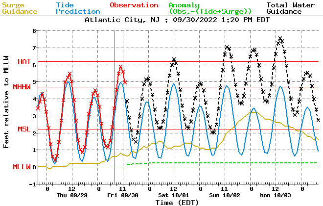
This will push a lot of the ocean towards NJ and should start building the tides up Saturday night or Sunday. Sunday currently looks like the first high tide of concern if not Saturday night (happens around noon-1pm on Sunday up and down coast). Each high tide from Sunday through Tuesday morning (3 high tides of concern) will likely then present at least minor coastal flooding along the ocean-facing NJ coast, especially SENJ. The coastal flooding concern would then drop once winds turn northerly which looks like Tuesday morning right now. Here’s the latest tidal guidance for Atlantic City illustrating the relationship between astronomical tides (blue) and storm surge (gold) to form the combined tidal prediction (black). Red means it’s in the past. Anything above the red Highest Astronomical Tide (HAT) line is likely at least minor flooding for coastal regions (possibly moderate):
In English: Rain is approaching from the S and will spread through NJ this evening/overnight (Friday into Saturday). Heavier rain should end by noon tomorrow with on-and-off nuisance conditions for the rest of Saturday into Sunday (cloudy onshore winds). On Sunday the steadier rain should come back with ECNJ/SENJ coastal flooding a concern Sunday-Tuesday. Winds should be moderate/breezy for most over this next 4-day stretch of conditions. Immediate coastal areas however, especially ECNJ/SENJ, could see wind gusts to 35-45mph. Most areas away from the ocean/inland should see lesser values. Some early indications of a colder air mass arriving Oct 7 and sticking around. Highs in the 50s/60s lows in the 30s/40s type stuff.
Premium Services
KABOOM Club offers inside info forecast discussion, your questions answered, and early storm impact maps (ahead of the public). At a buck per month, it’s an extremely feasible way to show support.
My Pocket Meteorologist (MPM), in partnership with EPAWA Weather Consulting, offers professional/commercial interests, whose businesses depend on outdoor weather conditions (snow plowing, landscaping, construction, etc.), with hyper-local text message alerts/forecasts and access to the MPM premium forum—the most comprehensive and technical forecast discussion available for PA and NJ.
Jonathan Carr (JC) is the founder and sole operator of Weather NJ, New Jersey’s largest independent weather reporting agency. Since 2010, Jonathan has provided weather safety discussion and forecasting services for New Jersey and surrounding areas through the web and social media. Originally branded as Severe NJ Weather (before 2014), Weather NJ is proud to bring you accurate and responsible forecast discussion ahead of high-stakes weather scenarios that impact this great garden state of ours. All Weather. All New Jersey.™ Be safe! JC


LOCAL FORECAST | INTERACTIVE RADAR | LATEST NJ WEATHER ALERTS | WEDDING FORECAST| PRIVACY POLICY
© Copyright 2026 Weather NJ LLC. All Rights Reserved.
Some information that can be found on our website is provided by a private weather station and is not an officially recognized station for weather reporting. Though we always strive to achieve accurate reporting for our own use, it is important that you do NOT depend on the data provided here for any purpose.
