

Ian’s Remnants to form Coastal Storm
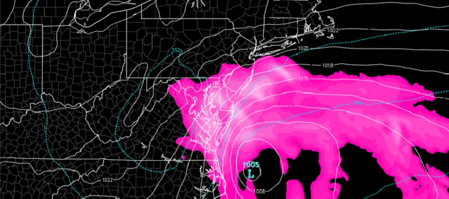
Discussion: The upper jet, observed at 250mb, is departing away from the NE US (to the E). The upper-level low energy associated with Ian’s remnants will now hang back and sit over the coastal Mid-Atlantic US until about Wednesday before it resumes E movement via the mid-latitude westerly flow. At the lower levels this means a weak surface low meandering offshore of Delmarva/Outer Banks in that same time period. It’s amazing to think how much impact Ian’s total energy had… starting with SE Caribbean development 9 days ago, crossing the Caribbean and making landfall in W Cuba, the W FL major hurricane landfall, the second SC hurricane landfall, the interior E US flooding, and now this for the coastal Mid-Atlantic US.
This last part of the system is not a powerful coastal low (expected 1000-1010mb) but it’s establishing on the foundation of back-built estuaries, creeks, streams, bays, and inlets that have already seen onshore flow for 24 hours. Therefore, regions that are normally subject to coastal flooding (along ECNJ/SNJ) should pay attention. These next few high tides should no doubt deliver at least minor levels of coastal flooding. Moderate is more likely and isolated major is not off the table.
Winds are very gusty along the ocean-facing coasts (I’ve seen gust reports of 50mph+) but just breezy-to-gusty at times away from the ocean. Expect this theme to continue until the system pulls away Wednesday. It’s this onshore flow that is pushing the ocean against the Jersey shore, into Raritan Bay, into Delaware Bay, etc. Once the winds turn from onshore to northerly, tidal concerns will start to subside however bayfronts facing W along barrier islands like LBI might see another flooding hit before all water drains out of the inlets. Just something to keep in mind when this wraps up Tuesday night or Wednesday.
Rain is the hardest thing to pinpoint in a system like this. It’s impossible to predict when each period of rain is going to start/stop. That’s why it’s better to have the higher-level expectation of just on-and-off periods of rain throughout this entire period ending Wednesday. Rain is not a big deal with this. New Jersey needs it. It’s the coastal flooding that has the headline of highest impact IMO with wind second, and rain last. Most people away from the ocean are just seeing nuisance conditions, probably saying “this is it?” The Jersey Shore however is just getting started and is in for a prolonged period of this.
In English: Rain and wind should continue today through Tuesday as Ian’s last remnants now form a weak but stalled coastal storm off the east coast. We need the rain and so far no intense flash flooding concerns…rain has been steady over prolonged period. Winds are most felt along immediate coasts (40-50+ mph) but nothing we haven’t seen before. It’s the coastal flooding along ECNJ/SENJ that I’m concerned about between today and Tuesday, especially during the high tides occurring just after ~noon/midnight each of those days. Expect solid minor, likely moderate, possibly major coastal flooding levels to occur. Everything should finally clear out by Wednesday as we eye up another colder, drier, fall feelz cold front Friday night. This would set up a clear, crisp, and dry weekend. More obs updates to come. Be safe! JC
Premium Services
KABOOM Club offers inside info forecast discussion, your questions answered, and early storm impact maps (ahead of the public). At a buck per month, it’s an extremely feasible way to show support.
My Pocket Meteorologist (MPM), in partnership with EPAWA Weather Consulting, offers professional/commercial interests, whose businesses depend on outdoor weather conditions (snow plowing, landscaping, construction, etc.), with hyper-local text message alerts/forecasts and access to the MPM premium forum—the most comprehensive and technical forecast discussion available for PA and NJ.
Jonathan Carr (JC) is the founder and sole operator of Weather NJ, New Jersey’s largest independent weather reporting agency. Since 2010, Jonathan has provided weather safety discussion and forecasting services for New Jersey and surrounding areas through the web and social media. Originally branded as Severe NJ Weather (before 2014), Weather NJ is proud to bring you accurate and responsible forecast discussion ahead of high-stakes weather scenarios that impact this great garden state of ours. All Weather. All New Jersey.™ Be safe! JC


LOCAL FORECAST | INTERACTIVE RADAR | LATEST NJ WEATHER ALERTS | WEDDING FORECAST| PRIVACY POLICY
© Copyright 2026 Weather NJ LLC. All Rights Reserved.
Some information that can be found on our website is provided by a private weather station and is not an officially recognized station for weather reporting. Though we always strive to achieve accurate reporting for our own use, it is important that you do NOT depend on the data provided here for any purpose.
