

Ice Approaching NNJ/NWNJ
Discussion: Icy conditions are possible NW of the NJTP/I-95 corridor Sunday morning…after a cold overnight tonight directly under high pressure. A low pressure system pretty far N in Canada will team up with return flow behind the departing high and first force a warm front over NJ. It’s the typical E and S side of the Norwegian Cyclone Model…first a warm front, then a warm sector, and lastly a cold front.
The warm front will start to arrive late tonight through tomorrow morning from the S/SW. Since warm air naturally rises, it will first rise above the cold surface and advect between ~925-700mb. So we have snow being created at ~10k feet, falling through a layer of above freezing temperatures (between 4k and 9k feet), and then reaching below freezing temperatures at the immediate surface. The snowflake, created just above the warm layer at ~10k feet melts as it falls in the warm layer (either completely to a rain drop or partially into an ice pellet) and hits the surface as a liquid drop that immediately freezes or an ice pellet. Depending on the depth of the warm layer determines freezing rain vs. sleet. Eventually the warmth from the warm layer is brought down to the surface and erodes ice. This is when you are in the warm sector which Jersey should be in from about 10am to 8pm Sunday. Then eventually the cold front comes through Sunday PM to kick off our Arctic air mass Monday-Wednesday of this upcoming week.
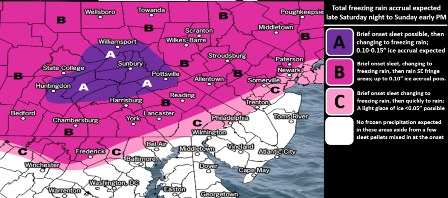
Again, this ice is a NNJ/NWNJ concern. Everyone in NJ SE, and probably along, the NJTP/I-95 corridor should quickly rise above freezing at the surface. It’s really areas NW of I-95, and especially that N of I-78/NW of I-287 NWNJ pocket who are most subject to this. Eastern PA is going to see more ice from this than NNJ due to timing. The precip arrives earlier for them (as early as tonight) during the colder temperatures. Most precipitation holds off for NJ until later Sunday morning and falls during a warmer time of day. But yeah ice, mostly likely in the form of freezing rain, is likely for NNJ/NWNJ tomorrow morning. This is our ice impact map:
Full resolution ice impact map.
So Sunday starts rainy with a cold/icy surface and ends rainy with a warmer surface. The cold front, an Arctic front, should then bring the coldest air mass of the season so far for Monday-Wednesday. I’m then seeing a slight moderation (still cold) and coastal storm signal Thursday-Friday (Jan 14-15) followed by another Arctic front later in the weekend. That Arctic front should then reload the region with more Arctic air and set the stage for the very favorable period of snowstorm development the following week. Based on the teleconnections and upper-level look from the N Pole down through North America, a large snowstorm is becoming likely in the Jan 18-22 period IMO. Let’s see how everything evolves with the first storm signal Jan 14.
In English: A bunch of rain is going to move through NJ on Sunday as temperatures rise above freezing. The problem is that they might not rise above freezing fast enough for areas NW of the turnpike, and especially N of I-78/NW of I-287 (the NWNJ elevations). Therefore, the rain that falls in that area will probably freeze on impact and create a freezing rain situation. The above map illustrates our concern for frozen type precipitation. Freezing rain is the most likely form but some sleet at first is also possible. This could impact travel tomorrow morning/afternoon for those NNJ/NWNJ locations. For everyone along and SE of the turnpike (especially all of SENJ), this looks like just rain on above-freezing surfaces (a rainy Sunday). Timing should be from mid-Sunday morning through Sunday afternoon. Temperatures should then drop Sunday evening/overnight for a very cold week ahead. I’ll have the weekly outlook out tomorrow. Have a great rest of your Sunday and please be safe! JC
Download the free Weather NJ mobile app on Apple or Android. It’s the easiest way to never miss Weather NJ content. Our premium services go even further above and beyond at the hyper-local level.
Jonathan Carr (JC) is the founder and sole operator of Weather NJ, New Jersey’s largest independent weather reporting agency. Since 2010, Jonathan has provided weather safety discussion and forecasting services for New Jersey and surrounding areas through the web and social media. Originally branded as Severe NJ Weather (before 2014), Weather NJ is proud to bring you accurate and responsible forecast discussion ahead of high-stakes weather scenarios that impact this great garden state of ours. All Weather. All New Jersey.™ Be safe! JC


LOCAL FORECAST | INTERACTIVE RADAR | LATEST NJ WEATHER ALERTS | WEDDING FORECAST| PRIVACY POLICY
© Copyright 2025 Weather NJ LLC. All Rights Reserved.
Some information that can be found on our website is provided by a private weather station and is not an officially recognized station for weather reporting. Though we always strive to achieve accurate reporting for our own use, it is important that you do NOT depend on the data provided here for any purpose.
