

Ice Event Detected for Northern New Jersey
Discussion: High pressure is now off to our E/SE in the Atlantic Ocean providing warm and moist S/SW return flow for NJ. Many of you dealt with fog/freezing fog this morning since saturation occurred prior to surface temps warming above 32. Temps have now climbed into the 40s for most, even 50s for some, and we’ll stay well above freezing until Friday when the Arctic front pushes through from the NW.
Tomorrow (Thursday) looks cloudy and rainy as periods of on-and-off rain should become more frequent throughout the day. During this time, we’ll still be on the warm side of the front (to the SE of it). Around midnight (give or take a few hours), NWNJ will drop below freezing at the surface. This line of freezing will continue to push SE through the rest of NJ Friday morning through afternoon. Temperatures in the air aloft will then follow the same pattern but lag slightly behind the surface advancement of the line of freezing. This will bring a wedge through NJ (like a doorstop wedge) of cold as the front advances from NW to SE. In sync, this will push a warm layer of air backwards (to the SE) in the shape of a reverse wedge (upside down doorstop wedge). Hence, the wintry precipitation type will be determined by how thick of a warm layer the precipitation falls through.
Areas with a deeper warm layer (SE side of the front) will see freezing rain. This means the rain falls through mostly above-freezing temperatures but freezes on impact due to a surface below 32. Areas with a shallower warm layer (NW side of the front) will see sleet. This means the rain falls through mostly below-freezing temperatures and freezes into an ice pellet before hitting the surface. Different from hail which is generated convectively during thunderstorms and/or warmer weather downpours. Areas completely to the SE of the front will obviously see rain with a completely above-freezing profile from surface to aloft. Areas completely to the NW of the front will obviously see snow with a completely below-freezing temp profile.
An Arctic high is pushing this front against the return flow of a Bermuda high. It’s the central convergence zone between the two (the long TX to ME boundary) that will generate the precipitation, not a wrapped-up cyclone. With that said, the flow from the two highs going against each other will elongate the angle of the “doorstop” wedge. I’ll use characters to illustrate it: Arctic high -> cold\warmth <- Bermuda High. Because of the elongation of that wedge, as the entire front advances, this is why there could be so much ice associated with it (for NNJ/EPA).
The wildcards, in either direction, will depend on the Arctic high’s influence of the frontal boundary. Less influence = less ice and more rain. More influence = more ice, maybe more snow, and less rain. Surface temperatures will be the biggest indicator of how fast the front actually moves through. I’ll be watching them and comparing to models very closely.
We have two different impact maps below. The first is for snow and sleet only since they are precipitation types that accumulate snowflakes/ice pellets. The second map is for freezing rain (hits surface as liquid rain but then freezes after impact) which accrues ice. As you can see, we expect freezing rain to affect more of NJ than snow or sleet. Note we have ECNJ colder than WCNJ due to the Arctic high flow direction along and just behind the front:
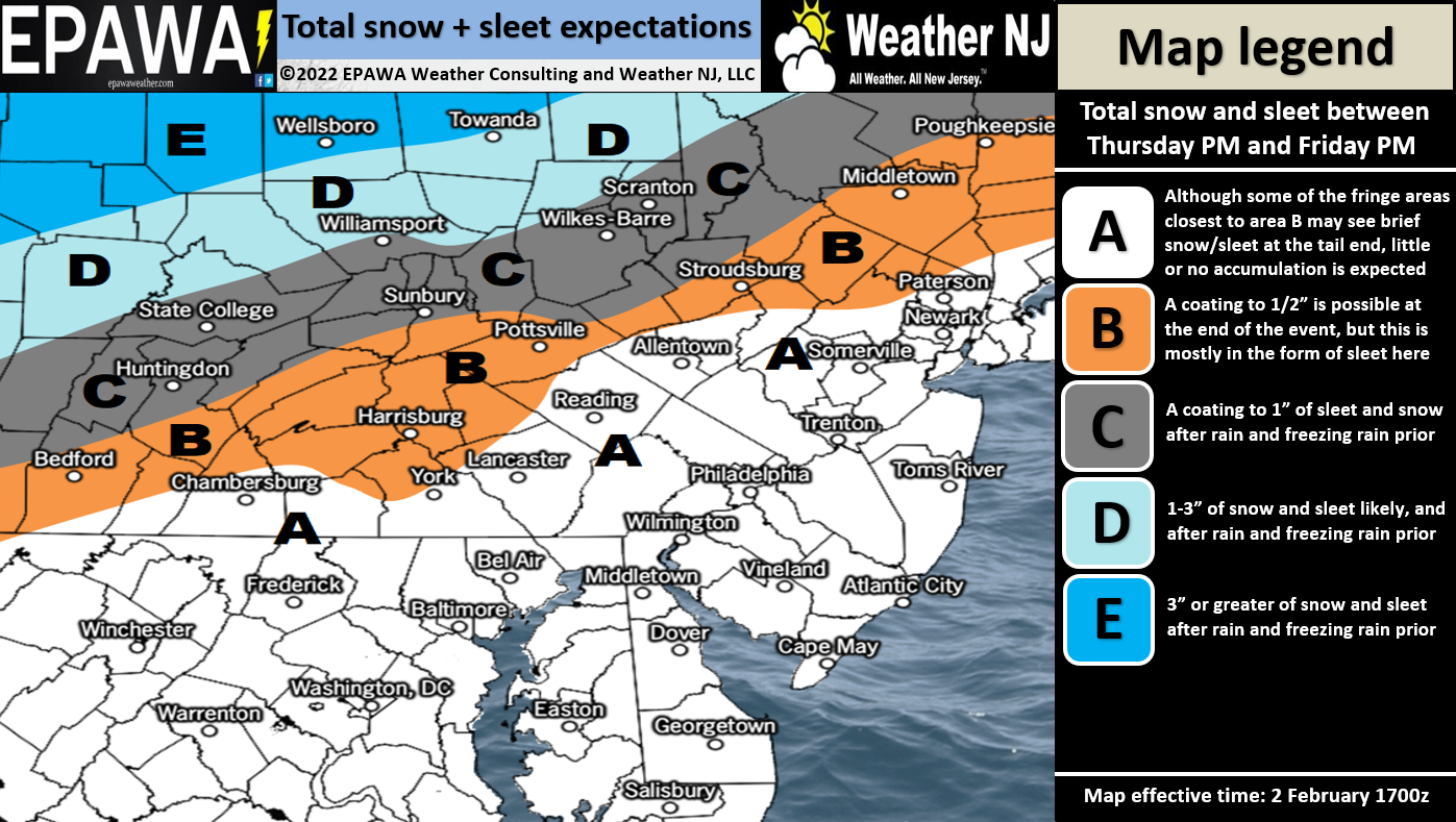
Click here for full-resolution snow/sleet map.
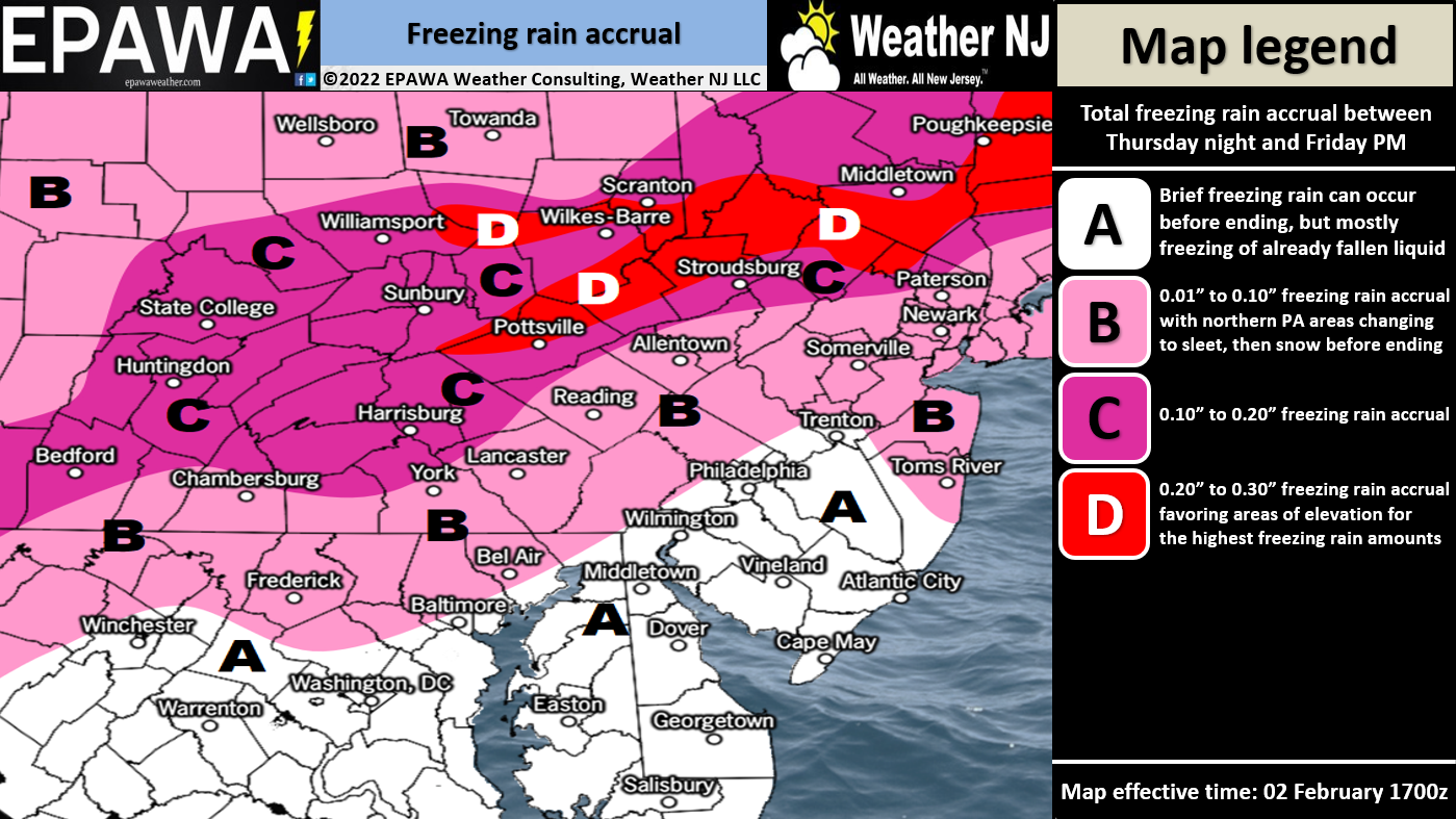
Click here for full-resolution ice map.
In English: Rain should move in by tomorrow morning (Thursday morning) if not by late tonight and become steady by Thursday afternoon/evening while temperatures remain above freezing. Around midnight (Thursday night) rain should start changing to freezing rain and sleet for NWNJ/NNJ. This changeover should then continue to the SE through the rest of NJ between early Friday morning and Friday evening as an Arctic front pushes through the precipitation. Finally, most areas (except for maybe coastal SENJ) should end with some level of tapering snow. Everyone SE of the turnpike/95 corridor should see mostly cold rain end briefly as light sleet or snow flurries with little-to-no accumulation or ice accrual. Areas NW of the turnpike/95 corridor should see a more impactful changeover to ice, especially extreme NWNJ/NNJ. The above impact maps represent our thoughts. Please take ice seriously. It only takes a little to ruin the day. We’ll start observations tonight. Otherwise expect a colder weekend behind the front with Sunday’s signal likely a miss to the S (likely hit for S Mid-Atlantic US).
Jonathan Carr (JC) is the founder and sole operator of Weather NJ, New Jersey’s largest independent weather reporting agency. Since 2010, Jonathan has provided weather safety discussion and forecasting services for New Jersey and surrounding areas through the web and social media. Originally branded as Severe NJ Weather (before 2014), Weather NJ is proud to bring you accurate and responsible forecast discussion ahead of high-stakes weather scenarios that impact this great garden state of ours. All Weather. All New Jersey.™ Be safe! JC


LOCAL FORECAST | INTERACTIVE RADAR | LATEST NJ WEATHER ALERTS | WEDDING FORECAST| PRIVACY POLICY
© Copyright 2025 Weather NJ LLC. All Rights Reserved.
Some information that can be found on our website is provided by a private weather station and is not an officially recognized station for weather reporting. Though we always strive to achieve accurate reporting for our own use, it is important that you do NOT depend on the data provided here for any purpose.
