

Ice Storm Developing
Discussion: A winter storm is brewing for New Jersey but snow accumulations are not the headline. Parts of NNJ might see some snow to start but the primary safety concern is ice in the form of sleet and/or freezing rain.
A quick refresher. Snow never melts from it’s formation to the surface. It remains a snowflake and falls through multiple layers of the atmosphere all at or below freezing. Sleet starts as snow but passes through a shallow warm layer aloft which melts the snowflake into a pellet known as sleet. It hits the ground as a sleet/ice pellet and accumulates like snow until it melts. Freezing rain is a snowflake that passes through a thicker warm layer aloft which melts the snowflake completely to a liquid rain drop. The liquid rain drop hits a below-freezing surface and freezes (accrues). And of course plain rain is just plain rain…liquid that falls on an above-freezing surface.
With this winter storm, we’ll be dealing with all 4 types of precipitation defined above. Therefore, on radar, there will be a snow/sleet line, a sleet/freezing rain line, and a freezing rain/plain rain line. These lines will start across NJ and slowly advance northward with the warm front throughout the system.
To recap, extreme NNJ (N of I-80/NW of I-287) has the best chance for initial snow accumulations. The rest of NNJ (lower elevations) and CNJ has the best chance for dangerous icing. SNJ has the best chance to start as ice but quickly go over to rain. Most of the icing for CNJ/SNJ will take place before sunrise Friday morning. Areas along and NW of I-95 (definitely N of I-78) have the best chance for educational/industrial closures and delays Friday morning.
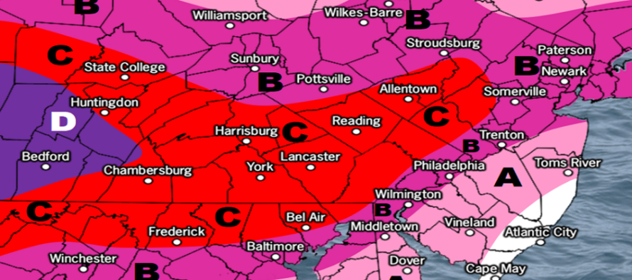
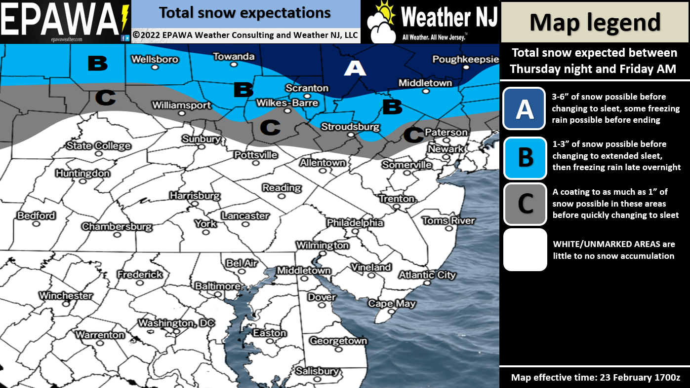
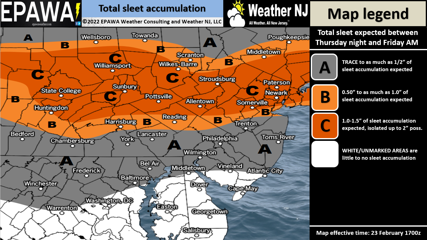
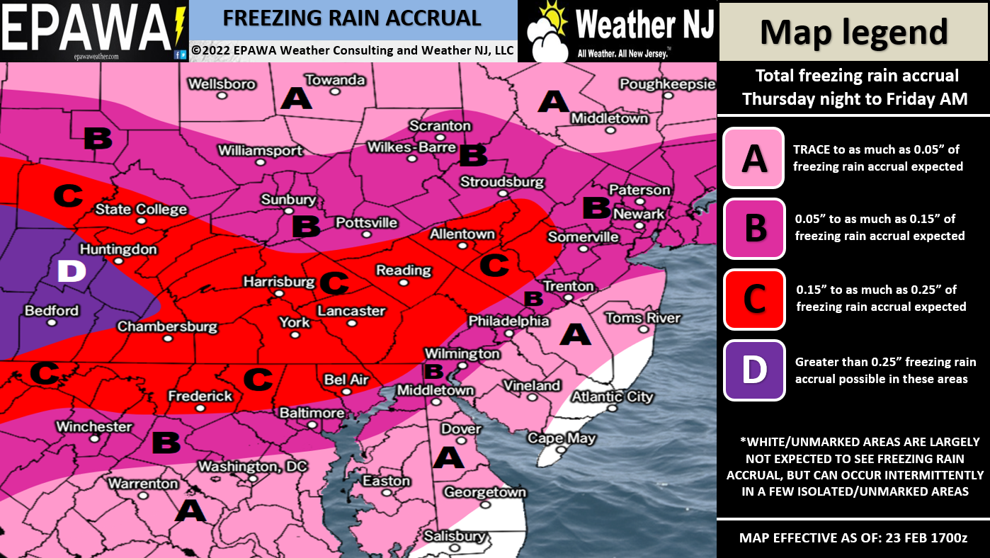
Timing is straightforward. Precipitation begins Thursday night between 7-10pm and ends by noon Friday with most of the wintry stuff falling between early and mid-Friday morning (2am to 6am-is). Only areas N of I-78 should still see wintry action after sunrise Friday and again, everything tapers off by noon Friday. Here are out wintry impact maps. There are three of them. One for snow (earlier in the system – Thursday night/early Friday morning), one for sleet (Friday early AM hours), and one for freezing rain (early-to-mid Friday morning). Rain is not included but should be assumed once surface temperatures rise above freezing for SNJ and then CNJ:
Full Resolution Freezing Rain Map
In English: I hope you all enjoyed the mild weather today. Tonight we’ll drop into the 20s and tomorrow most areas should be held in the mid-30s before dropping back below freezing heading into the wintry system tomorrow night. It’s not a lot of snow but a decent amount of ice that could impact travel safety this Thursday night into Friday. It should start between 7-10pm tomorrow night (Thursday night) and end by noon Friday. During that time, NNJ should start as snow but chance to ice. CNJ should start as snow/ice but change to ice/rain. SNJ should start as ice but quickly go over to rain. These changeovers should all mostly occur pre-sunrise Friday however hazardous icing could affect safety through noon Friday, especially N of I-78. Will make any tweaks and adjustments tomorrow when the system is approaching but this is how it looks for now. Have a great Wednesday night and please be safe! JC
Jonathan Carr (JC) is the founder and sole operator of Weather NJ, New Jersey’s largest independent weather reporting agency. Since 2010, Jonathan has provided weather safety discussion and forecasting services for New Jersey and surrounding areas through the web and social media. Originally branded as Severe NJ Weather (before 2014), Weather NJ is proud to bring you accurate and responsible forecast discussion ahead of high-stakes weather scenarios that impact this great garden state of ours. All Weather. All New Jersey.™ Be safe! JC


LOCAL FORECAST | INTERACTIVE RADAR | LATEST NJ WEATHER ALERTS | WEDDING FORECAST| PRIVACY POLICY
© Copyright 2026 Weather NJ LLC. All Rights Reserved.
Some information that can be found on our website is provided by a private weather station and is not an officially recognized station for weather reporting. Though we always strive to achieve accurate reporting for our own use, it is important that you do NOT depend on the data provided here for any purpose.
