

Ida Remnants Approaching NJ
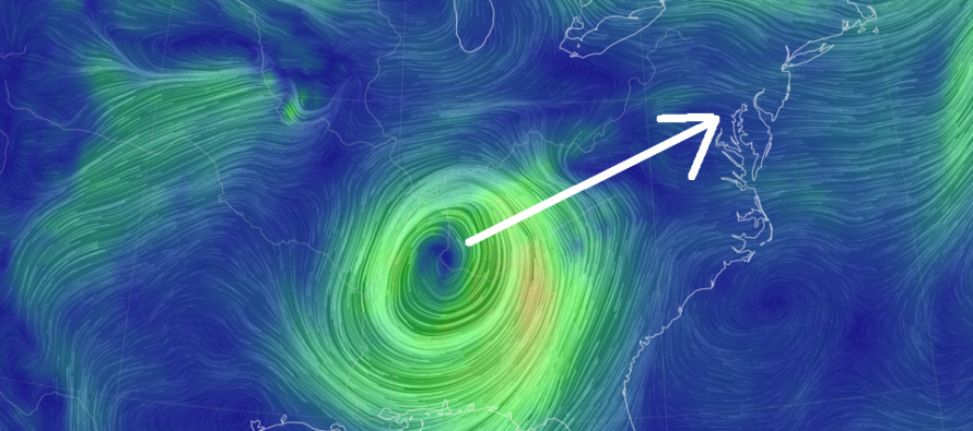
Discussion: Ida has absorbed into the approaching trough and developing front. It is now well on its way into extra-tropical transition which means it is now a cold core mid-latitude cyclone, with frontal boundaries developing, rather than a warm core tropical cyclone.
We’ve dealt with a few tropical cyclone remnants in the past few weeks after dealing with Isaias last year. In past cases, there were tornado threats associated because of the tropical swirl still being intact. That is not the case this week. We will not be located in the NE quadrant of a tropical cyclone and therefore the tornado threat is not high. Tornadoes are still possible however for NJ since we’ll be in a ripping warm sector ahead of the storm. IMO the best dynamics for tornadoes to occur is NWNJ/NNJ/CNJ.
We’re likely dealing with heavy rainfall and light-to-moderate winds. Rainfall could impress, especially along the heavier axis. Right now this heavier axis should set up anywhere between NWNJ and CNJ depending on low track and frontal advancement. SENJ is favored for the least amount of rainfall but please do not let your guard down. All of NJ is on the hook for periods of heavy rain capable of producing flash flooding. It is very possible that a sharp cutoff could exist across CNJ/SNJ. You might see areas like Cape May through Atlantic City see very little rain while the I-95 corridor and points NW see inches+.
The winds should not be bad. Again, we’re going to deal with a mid-latitude cyclone of about ~995mb of intensity/central low pressure. Typically this produces sustained winds of 15-25mph with gusts to 40mph. I’m not even sure we’ll see that widespread.
The wildcard are embedded thunderstorms within the heavy frontal/low rain. In places where this happens, locations could fall subject to isolated thunderstorm caliber winds (58mph+ gusts if severe-warned) or higher if a tornado does touch down.
The timing has been flopping around quite a bit. Most models are starting the rainfall as early as Wednesday (tomorrow) morning. Some models are starting the rain by late morning. In either case, it’s safe to say that conditions will deteriorate between tomorrow morning and afternoon, peak between tomorrow afternoon and early Thursday AM, and then improve throughout Thursday (noon-forward). That’s the best I can do for now and I will update again tomorrow morning if anything changes.
In English: Expect periods of heavy rain this Wednesday-Thursday. Should start for most locations by noon Wednesday and end for most locations by noon Thursday. NWNJ is favored for the most amount of rain and SENJ for the least amount of rain. We could still see a scenario, however, where 4-6+ inches of rain falls for NWNJ, maybe some of NNJ/CNJ, and maybe 1-2 inches of less for SENJ, especially extreme SENJ. So, a statewide heavy rain absolutely capable of producing flash flooding. Winds will be very run of mill for a typical rainstorm but likely not destructive widespread. Isolated instances of damaging winds would be associate with an isolated embedded thunderstorm or tornado, not the overall decaying tropical energy. Friday into the weekend still looks gorgeous after everything clears out with the departing remnants and front late Thursday night. Have a great rest of your Tuesday and please be safe! JC
Download the free Weather NJ mobile app on Apple or Android. It’s the easiest way to never miss Weather NJ content. Our premium services go even further above and beyond at the hyper-local level.
Jonathan Carr (JC) is the founder and sole operator of Weather NJ, New Jersey’s largest independent weather reporting agency. Since 2010, Jonathan has provided weather safety discussion and forecasting services for New Jersey and surrounding areas through the web and social media. Originally branded as Severe NJ Weather (before 2014), Weather NJ is proud to bring you accurate and responsible forecast discussion ahead of high-stakes weather scenarios that impact this great garden state of ours. All Weather. All New Jersey.™ Be safe! JC


LOCAL FORECAST | INTERACTIVE RADAR | LATEST NJ WEATHER ALERTS | WEDDING FORECAST| PRIVACY POLICY
© Copyright 2026 Weather NJ LLC. All Rights Reserved.
Some information that can be found on our website is provided by a private weather station and is not an officially recognized station for weather reporting. Though we always strive to achieve accurate reporting for our own use, it is important that you do NOT depend on the data provided here for any purpose.
