

Strange Weather Ahead (July 13-19)

There’s been some buzz about the Polar Vortex (PV) returning this coming week. Let me assure you that it’s very far away and has no plans to pass over New Jersey anytime soon. It’s mid-July for crying out loud! Here’s what actually happened and what’s going to happen in the next week. The circulation center of the Polar Vortex is very far to our north this time of year. Colder polar energy, however, revolves around it (around the higher latitudes of the northern hemisphere) and sometimes extends a radius from the PV center far enough to reach into the US. It swings down and through the US like a pendulum before moving off the the northeast. As it’s swinging through you can clearly make out a “U” shaped pattern in the jet stream which is known as a trough. That is going to happen over the eastern 2/3 of the US this coming week but a little more pronounced than normal. Why?
A recent typhoon in the Pacific Ocean has disrupted the jetstream and that has now rippled downstream to the US. This enhanced trough will pull colder air down from Canada and keep our region cooler from about Wednesday through Saturday. I wouldn’t expect crisp and dry visibility either. These kind of upper level-driven toughs can keep it cloudy and damp with on-and-off rain showers. With that being said, I think highs will be in the 70s while overnight lows bottom out in the 50s statewide. Here’s to hoping for more sun than clouds but cool and damp is probably the best bet for now. Here’s some GFS guidance showing expected surface temperature anomalies (departures from average for this time of year):
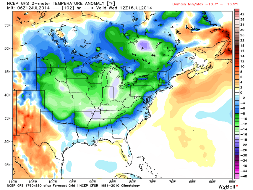
The above slide is specifically showing Wednesday morning with temperatures as much as 8-12 degrees below average in NWNJ. You can see how areas closer to the ocean will be more regulated so not as much of an impact there. Again, I expect these cool and “more damp than dry” conditions to last well into the weekend.
What’s has me somewhat concerned is the possible outcome of such a cool air mass moving into a warm air mass that will build tomorrow through Tuesday. It should be a slow and gradual takeover that could span from Monday afternoon through Wednesday morning. This creates a decent stormy window of time. My initial thoughts are that scattered cloud cover will be plentiful throughout the region which would cut off diurnal surface heating and limit instability. For the most part that means less of a light show from towering cumulonimbus cloud cells. I’m thinking the headlines for this period will be rainfall amounts and wind damage. There will be plenty of moisture in the atmosphere and decent wind shear.
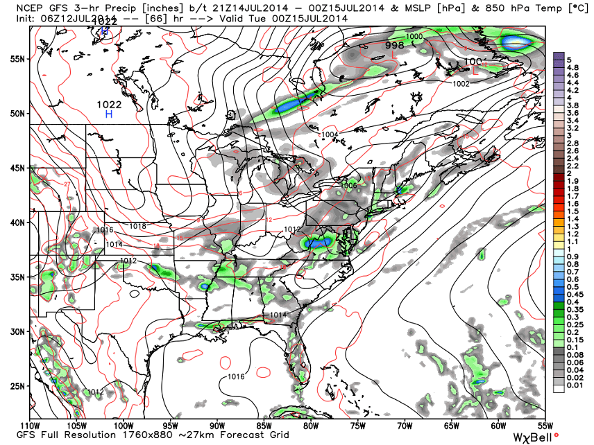
Are we talking about a widespread severe outbreak of tornadoes and hail? Probably not. This should be more of a scattered severe situation. Most should deal with just gusty rain and rumbles while some areas do experience the more damaging winds. Impossible to determine who the “some” will be at this point in time. This GFS slide for Monday seems to be on point in demonstrating the scattered nature. You can also somewhat depict the wind shear by the irregularness of mid-Atlantic US pressure isobars:
So what does this mean in English? Expect the heat and humidity to return tomorrow and stick around (I swear no pun intended) through possibly Tuesday night. That window of enhanced humidity also carries the chance for severe thunderstorms at any time but most likely in the afternoon/evening hours. When it’s all through by Wednesday morning, expect cold and possibly damp conditions to last into the weekend.
I’ll revisit this all tomorrow. Everyone enjoy the rest of your weekend and please be safe! JC
Image Credit: Chase Shiefer Photography
Jonathan Carr (JC) is the founder and sole operator of Weather NJ, New Jersey’s largest independent weather reporting agency. Since 2010, Jonathan has provided weather safety discussion and forecasting services for New Jersey and surrounding areas through the web and social media. Originally branded as Severe NJ Weather (before 2014), Weather NJ is proud to bring you accurate and responsible forecast discussion ahead of high-stakes weather scenarios that impact this great garden state of ours. All Weather. All New Jersey.™ Be safe! JC


LOCAL FORECAST | INTERACTIVE RADAR | LATEST NJ WEATHER ALERTS | WEDDING FORECAST| PRIVACY POLICY
© Copyright 2026 Weather NJ LLC. All Rights Reserved.
Some information that can be found on our website is provided by a private weather station and is not an officially recognized station for weather reporting. Though we always strive to achieve accurate reporting for our own use, it is important that you do NOT depend on the data provided here for any purpose.

)