Into the Unknown

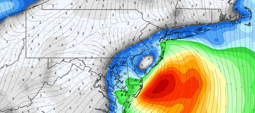
Discussion: Elsa is barely hanging onto tropical storm criteria with maximum sustained winds at 40mph with gusts to 45mph. She’s currently near the east-central border of NC/SC with rain bands extended as far N as Virginia (approaching S tip of Delmarva). Elsa’s core should track across E VA, Delmarva, and ultimately the SENJ/ECNJ coast between today and tomorrow morning. By the time it gets to NJ it might be classified as a sub-tropical or extra-tropical cyclone once weakening below TS criteria. So what does this mean for NJ? Let’s break it down by hazard:
Rain: I expect total rain amounts to generally range from 1 to 2 inches from NWNJ to SENJ. The timing of the rain should be between 10pm tonight (Thursday night) and 8am tomorrow morning (Friday morning). SNJ could see the rain end as early as 6am with NENJ the last to clear closer to 8am. Not that big of a deal
Wind: Areas away from the SENJ/ECNJ coast will likely see very run-of-mill winds for a coastal disturbance (not a big deal). Areas right along the SENJ/ECNJ and just inland will see the greatest winds but nothing crazy. Sustained winds along the immediate coast should fall into the 20-30mph range with gusts of 40-50mph possible. Wind direction will rock and correlate with the cyclonic flow around the center of circulation. We’ll see S/SE flow tonight (Thursday night) become SE flow for the peak winds (between midnight and sunrise-ish Friday). Wind direction will then quickly change to the NW once the center of circulation clears NJ to the NE between 6-8AM (Friday).. We’ve seen many stronger nor’easters that last much longer than this.
Coastal Flooding: The closest passage of the storm will occur between late tonight (Thursday night) and early Friday AM. This times very well with low astronomical tide. And thank goodness for that because we’re close to a full moon. Even still, this system will be a quick mover so the SE-E/SE-E wind component will be limited to a few hours. With all of that said, coastal flooding should only just break into the minor category, if that, during the greatest surge period. By the time high tide rolls around closer to noon on Friday, the system will be way to our NE and we’ll be seeing NW wraparound winds from the back-side of the system. So no major coastal flooding threat.
Wildcard Severe: The above hazards, as I’ve stated, are not a big deal. We’ve seen this before many times and that’s how I expect things to shake out overall and in general. However we need to discuss the wildcard potential that could occur at a localized level. The surface and low-mid levels will see a decent amount of vertical wind shear, especially on the N/NE/E side of the center of circulation. When Elsa’s core is over Delmarva, at least SENJ, maybe more of SNJ and CNJ will be in this zone (early Friday AM hours). During this time, said zone could encounter embedded thunderstorms and even an EF-0/EF-1 tornado. The vertical shear will be generated from S surface flow under the circulating low-mid level flow wrapping around the E side of the center of circulation. So thunderstorms and tornadoes are possible at the localized level in SENJ, maybe more of NJ between about midnight and 5am Friday morning. Obviously both could produce a localized wind profile greater than “gusts to 50mph.”
In English: Tropical Storm Elsa should weaken and pass over SENJ between late tonight and early Friday morning. Expect periods of heavy “tropical-feeling (warm and drenching/misty)” rainfall with increased winds, especially along the coast (outages possible). Really not a big deal at all away from the coast…more of a nuisance. In general, nothing looks catastrophic or damaging widespread however isolated embedded thunderstorms and tornadoes are a small possibility. Where these isolated instances of severe winds could take place is impossible to determine at this point. Therefore we’ll have to go into the unknown. I’ll check back later tonight when Elsa (or her sub-tropical remnants) are approaching NJ from the SW. Have a great rest of your Thursday and please be safe! JC
Download the free Weather NJ mobile app on Apple or Android. It’s the easiest way to never miss Weather NJ content. Our premium services go even further above and beyond at the hyper-local level.
Model image source: WeatherBell Analytics
Jonathan Carr (JC) is the founder and sole operator of Weather NJ, New Jersey’s largest independent weather reporting agency. Since 2010, Jonathan has provided weather safety discussion and forecasting services for New Jersey and surrounding areas through the web and social media. Originally branded as Severe NJ Weather (before 2014), Weather NJ is proud to bring you accurate and responsible forecast discussion ahead of high-stakes weather scenarios that impact this great garden state of ours. All Weather. All New Jersey.™ Be safe! JC


