

It Could be a Wintry Week!
Discussion: We’re going to return to daily article mode this week as there is a lot unfolding. And yes, I’m leaving the cover image up.
First, our snow map issued yesterday for tomorrow (the light NNJ event) will stand as called with a caveat that we’re not seeing much rain or mix for zones A and lower half of C. This doesn’t affect the snowier N side of NJ expecting the light accumulation of snow. It only affects the S side of NJ and some of CNJ who weren’t expecting much of anything anyway. The disturbance traverses the thermal gradient tonight, running W to E through S Canada and down across the E Great Lakes through the Mid-Atlantic. It does so with the gradient advancing northward as a warm front Tuesday. Overrunning precipitation falls colder for NNJ/CNJ, prior to the warm front passage, between about midnight tonight and 10am Tuesday. It leaves NNJ, possibly some of CNJ, with a light accumulation (most in the elevations) while again, SNJ and lower CNJ possibly see little to no precipitation at all…and in the form of rain for whatever is seen. Due to the gradient running NW to SE, places like Monmouth County will perform colder than Mercer County and places like NENJ, who normally fall victim to coastal plain warming, will stay on the colder side. The idea is that the snow happens for NNJ/CNJ earlier Tuesday (50-75% of precip before sunrise) while it’s still cold enough…before NJ warms up later Tuesday with much of SNJ/CNJ approaching 40 degrees. Just keep in mind that the warm front will start advancing and warming temps from SW to NE as early as 3am. So even if CNJ sees a wintry burst to start overnight, it will likely change to ice as temps approach and rise above 32F at the surface. Even once NNJ finishes up their wintry precip, the warm front will continue advancing to the NE of NJ…so a lot of what sticks could melt later Tuesday. This should give NJ a milder break for Christmas Eve and the first half of Christmas Day in the wake of that. The boundary then reverses drifts back to the SW, as a cold front, on Christmas Day night into early Friday Dec 26.
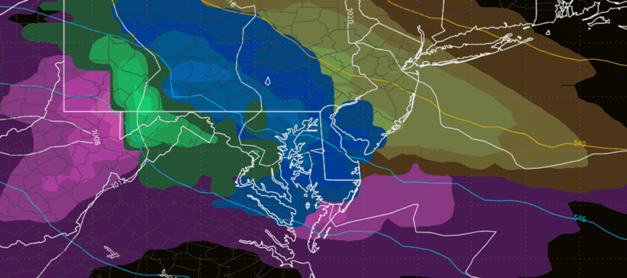
The reason I say it might be a snowy week is because of the next wintry signal unfolding for this Friday-Saturday (Dec 26-27). It’s a similar setup as tomorrow (Tuesday) in terms of the jet/gradient track and principals of the boundary (running NW to SE) however the boundary is expected to be further SW (to the SW of most of NJ) with high pressure overhead. Therefore, everyone would be colder on the NE side of the boundary with the high pressure reinforcing the boundary to the SW from its front side anti-cyclonic flow. The least likely to see a snow accumulation would be SWNJ being closest to the boundary. So, with that said, a lot of NJ could be looking at a significant wintry event this Friday-Saturday (Dec 26-27) in the form of ice or snow. From this range, the GFS model is the coldest and snowiest (pictured above in the cover image – gold is snow and blue is ice). The Canadian has a slizzard (blizzard of sleet lol). The Euro operational came in closer to the Canadian however the Euro ensembles supported the GFS’s snowier outcome which is a stronger piece of data from this range IMO.
For now, here’s our unchanged final call for tomorrow’s expectations. A high-level from the hip take indicates Snow for NNJ, ice for CNJ, and rain for SNJ. But it should be a little more dynamic than that given the advancing warm front and gradient running NW to SE. Again, not a huge deal S of I-78 however all should use caution as it doesn’t take much to slick things up. Want to drill in that for zone A in SNJ and southern half of zone C in CNJ…precipitation is modeled the lightest here. It is possible that little-to-no rain actually falls, however anything that does fall would likely be rain in zone A and an icy mix to rain in the southern half of zone C. NNJ and the northern half of CNJ have the best shot at cold precipitation.
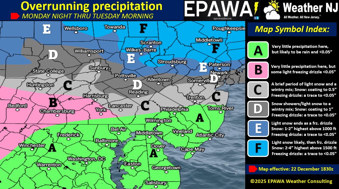
In English: Temps will drop after sundown tonight and snow will move into NNJ and some of CNJ by midnight-ish tonight (Monday night). From midnight until sunrise (about 715am) will be the best chance for NNJ/CNJ (N of I-78) to see snowfall that accumulates. A good chance that SNJ stays dry until later Tuesday morning (until 5am or after). SNJ and the lower half of CNJ could possibly get skunked on precipitation in a dry slot…anything that does fall in SNJ and the lower half of CNJ would likely be in the form of rain or an icy mix changing to rain. It’s not like SNJ should expect a solid rain soaking because it looks very dry for said areas. After all, this is a clipper which are typically moisture-starved. Zones D, E and F stand the best chance to see a light accumulation of snow before things warm up later Tuesday. This system has consistently been modeled as a light snow event for mainly NNJ (N of I-78). Our snow map above remains unchanged from yesterday’s first call. We then stay on the milder side for Christmas Eve and some of Christmas Day before turning colder again by Friday morning. Then I’m watching Friday night into Saturday for a colder wintry signal, capable of delivering snow to more of NJ. Will start to address this more publicly tomorrow once the morning system moves out. In the meantime, we’ll be geeking out over it in KABOOM Club. Have a great rest of your Monday night and please be safe! JC
Premium Services
KABOOM Club offers an ad-free environment, inside info (Above and Beyond) forecast discussion, your questions prioritized, and early storm impact maps and video releases (ahead of the public). At $1.99 per month, it’s an extremely feasible way to show additional support for Weather NJ and you can turn it on and off for however many months you wish. Think of it as a tip jar with perks. Available onFacebook or Patreon.
My Pocket Meteorologist (MPM), in partnership with EPAWA Weather Consulting, offers professional/commercial interests, whose businesses depend on outdoor weather conditions (snow plowing, landscaping, construction, etc.), with hyper-local text message alerts/forecasts from real meteorologists and access to the MPM premium forum—the most comprehensive and technical forecast discussion available for PA and NJ commercial interests.
KABOOM Shop is live if you want some KABOOM or Weather NJ Merch!
Sign up for ZoneWatch Radar and get 10% off
Jonathan Carr (JC) is the founder and sole operator of Weather NJ, New Jersey’s largest independent weather reporting agency. Since 2010, Jonathan has provided weather safety discussion and forecasting services for New Jersey and surrounding areas through the web and social media. Originally branded as Severe NJ Weather (before 2014), Weather NJ is proud to bring you accurate and responsible forecast discussion ahead of high-stakes weather scenarios that impact this great garden state of ours. All Weather. All New Jersey.™ Be safe! JC


LOCAL FORECAST | INTERACTIVE RADAR | LATEST NJ WEATHER ALERTS | WEDDING FORECAST| PRIVACY POLICY
© Copyright 2026 Weather NJ LLC. All Rights Reserved.
Some information that can be found on our website is provided by a private weather station and is not an officially recognized station for weather reporting. Though we always strive to achieve accurate reporting for our own use, it is important that you do NOT depend on the data provided here for any purpose.
