

I’ve Seen Better
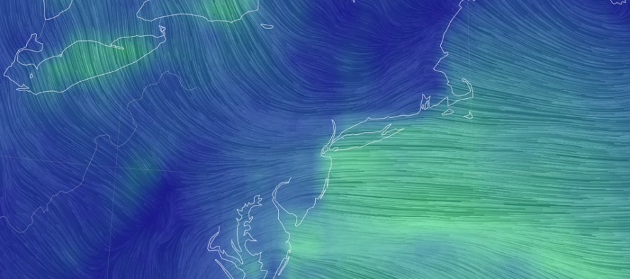
Discussion: Upper-level ridging over E Canada/E US will continue to dominate the weather pattern likely through next weekend. That means a string of above-average temperatures and conditions I generally dislike this time of year. The kind of weather that’s perfect for early spring warmth but not as welcome in fall when most expecting cool and crisp conditions. Anyway, we first need to get through this weekend. High pressure over extreme NE US/SE Canada will provide E flow into NJ tomorrow (Saturday) through Monday. A low will also track offshore from SE US to the Mid-Atlantic US. The N side of this low will contribute to the onshore fetch out of the E. Therefore, were looking at about 48 hours of stiff E winds, felt much more at the coast than inland. This presents a coastal flooding risk for immediate coastal areas of ECNJ/SENJ, especially during the 6-8 high tides that should occur within the period of strongest surge-generating wind. It looks like the noon-ish period of Sat, Sun, and Mon should see the highest water levels. Easily a moderate coastal flooding risk IMO. Some rain here and there, especially Sunday night into Monday Morning with the coastal low nearby, but otherwise a nuisance away from the ocean. A much more felt situation at the coast. We should see improvement by Monday night ahead of the warm and dry week. Long-range guidance has a smack-down cold front next Sunday but let’s get closer before buying into it.
Saturday (Oct 9) high temperatures should reach near-70 for most areas. Skies should be mixed with heavy clouds and some sun. Showers are possible. Winds should be light/breezy out of the E/NE for most areas away from the ocean. Immediate coastal regions of ECNJ/SENJ should feel stiff/gusty winds out of the E/NE. Overnight lows should fall into the low-to-mid 60s for most areas as showers and wind persist. Coastal flooding is likely, especially during high tide. With that said, expect intensified surf.
Sunday (Oct 10) high temperatures should reach the mid-to-upper 60s for most areas. Skies should be mostly cloudy with more periods of rain likely. Winds should remain out of the general E, lighter away from the ocean but gusty along immediate ocean-side coastal areas. Coastal flooding possibility and intensified surf will continue through Sunday. Overnight lows should fall to near-60 as rain chances drop off with a damp/windy general feel.
Monday (Oct 11) high temperatures should reach the lower-70s for most areas. Skies and humidity should gradually improve throughout the day. Winds should relax and change to NE or even N/NE. Overnight lows should range from mid-50s to mid-60s from NNJ elevations to SNJ coasts.
An early look at next week indicates warm temperatures. Highs ranging from 70-80 but with a drier feel and little-to-no rain. Overnight lows into 50s/60s. Imagine how you’d want a nice late-May/early-June day to feel. Let’s tale a closer look on Monday evening. Everyone have a great weekend and please be safe! JC
Download the free Weather NJ mobile app on Apple or Android. It’s the easiest way to never miss Weather NJ content. Our premium services go even further above and beyond at the hyper-local level.
Jonathan Carr (JC) is the founder and sole operator of Weather NJ, New Jersey’s largest independent weather reporting agency. Since 2010, Jonathan has provided weather safety discussion and forecasting services for New Jersey and surrounding areas through the web and social media. Originally branded as Severe NJ Weather (before 2014), Weather NJ is proud to bring you accurate and responsible forecast discussion ahead of high-stakes weather scenarios that impact this great garden state of ours. All Weather. All New Jersey.™ Be safe! JC


LOCAL FORECAST | INTERACTIVE RADAR | LATEST NJ WEATHER ALERTS | WEDDING FORECAST| PRIVACY POLICY
© Copyright 2026 Weather NJ LLC. All Rights Reserved.
Some information that can be found on our website is provided by a private weather station and is not an officially recognized station for weather reporting. Though we always strive to achieve accurate reporting for our own use, it is important that you do NOT depend on the data provided here for any purpose.
