

Jan 11: Monday Ice Storm Approaching!
Just a few tweaks to the forecast/map but here’s my final call…
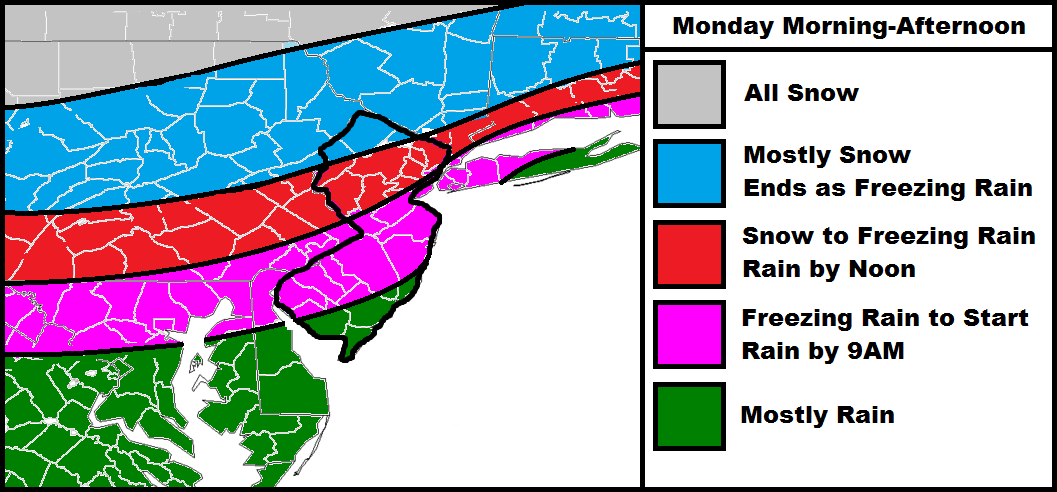
Warmer air is surging northward in the mid levels of the atmosphere. The surface is holding on to colder temperatures at the surface longer. Precipitation starts as rain in the warmer mid levels but freezes when it hits the surface if the surface is still 32F or below. That’s the main idea with this system for the northern 2/3 of the New Jersey as it approaches and moves through the region. NWNJ will remain coldest at the surface for the longest. SENJ is already above freezing at the surface. The area between is subject to the most amount of ice in the form of freezing rain.
For my map all I did was take the big pink area from last night’s map and break it into two areas. The current pink area on this map will go over to rain quicker than the red area. If you’re in the red or blue area of this map, you should prepare for major delays through noon. If you’re in the pink area, expect slick conditions but only until sunrise…maybe 9AM at the latest. Everything should be clear by late afternoon. Temperatures will drop tomorrow night again and could result in black ice so be careful after sunset! I hate ice. I’d rather drive in 6 inches of snow than .1 inch of ice. This is my final call. No “In English” necessary. It’s now time for live-casting. Please be safe! JC
Jonathan Carr (JC) is the founder and sole operator of Weather NJ, New Jersey’s largest independent weather reporting agency. Since 2010, Jonathan has provided weather safety discussion and forecasting services for New Jersey and surrounding areas through the web and social media. Originally branded as Severe NJ Weather (before 2014), Weather NJ is proud to bring you accurate and responsible forecast discussion ahead of high-stakes weather scenarios that impact this great garden state of ours. All Weather. All New Jersey.™ Be safe! JC


LOCAL FORECAST | INTERACTIVE RADAR | LATEST NJ WEATHER ALERTS | WEDDING FORECAST| PRIVACY POLICY
© Copyright 2026 Weather NJ LLC. All Rights Reserved.
Some information that can be found on our website is provided by a private weather station and is not an officially recognized station for weather reporting. Though we always strive to achieve accurate reporting for our own use, it is important that you do NOT depend on the data provided here for any purpose.
