

Jan 11: Updated Weekend Snow Map
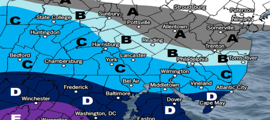
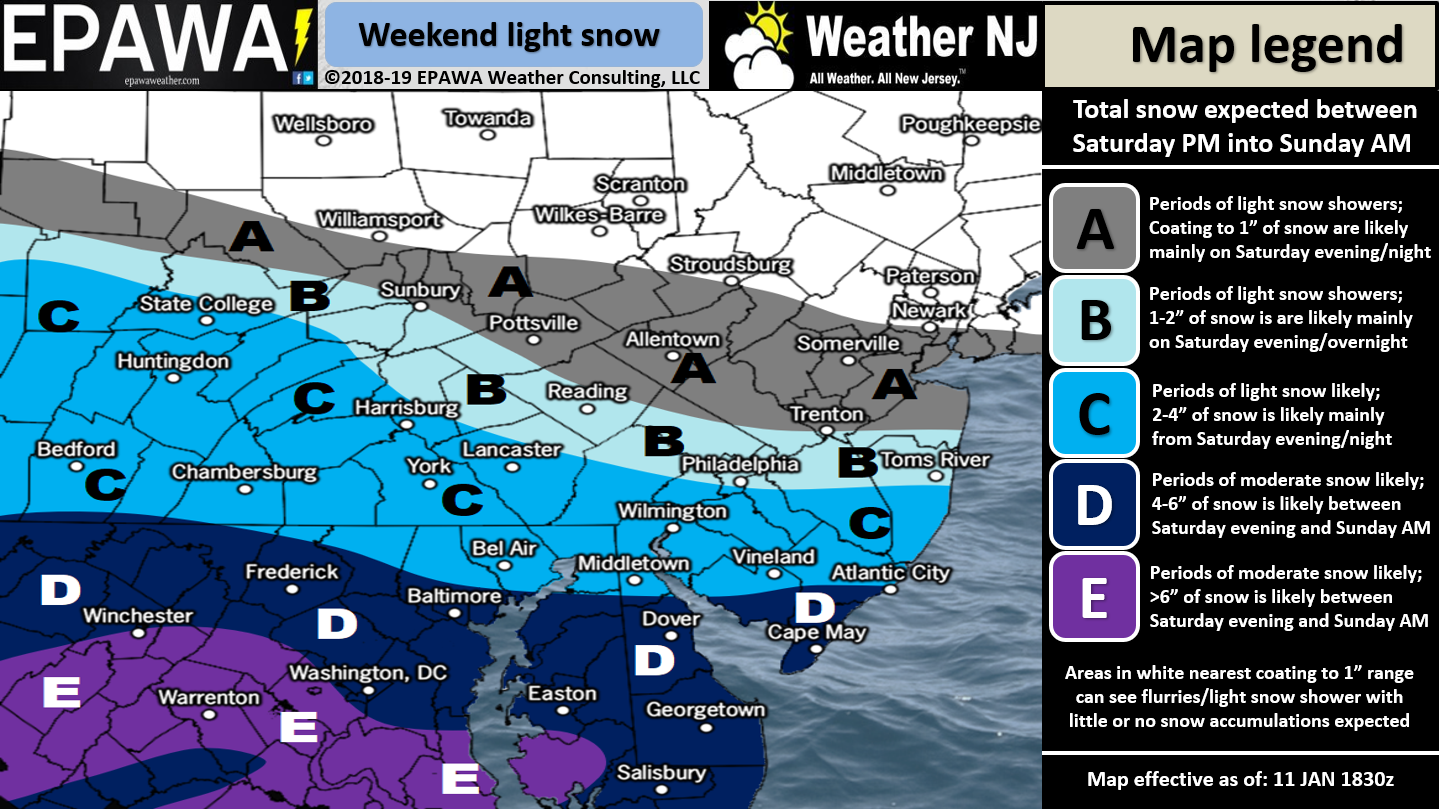

Discussion: Dynamics are leaning towards the heavier wildcard from yesterday’s discussion. It’s still not looking like a shut-down snow storm but it could mean a plowable event for a larger part of SNJ. We’re dealing with a fairly weak, but strong-enough, low that will track across the SE US and eject into the Atlantic Ocean somewhere over OBX. If this system were to turn up the coast and bomb out then we would be looking at a monster. But that is not the case. Instead the system should continue it’s eastward travels out into the ocean. The low will be strong enough to throw a lot of moisture northward but we also have a very strong high to our N which will move from W to E with the low. This high is sourcing very cold and dry air and is mainly the reason for the sharp cut-off through CNJ/NNJ. The confluence will simply devour the precipitation on the north side of the overall precipitation shield. But where the high and low meet with air currents (where the strongest pressure gradient is expected to form) snowfall should be heavier. Right now that area is represented by the lower-half of our map especially through areas like Virginia and the lower Delmarva Peninsula. Our snow map above represents our best evidence-based estimate of snowfall. Consider it a mean average between all possibilities including the outer wildcards.
To cover the wildcards, first would be the lower-impact scenario. The confluence could have more impact than expected which would produce a lot of virga (snow that evaporates before hitting the ground but still shows on radar). In this case snowfall amounts would verify on the lower end of expectations. The second would be the higher-impact scenario. If the surface convergence can enhance lifting and/or the strong upper-level jet can enhance/expand the precipitation shield then this system would verify on the higher side of expectations, possibly even higher for SNJ and especially for SENJ. Again, our map above represents the middle/mean/average of all evidence collected from model data and live observations. But my gut has the feel here for at least extreme SNJ.
Timing of this event has always surrounded a prolonged period of at least light snow. We now feel that SNJ areas are subject to light-to-moderate snowfall rates. I wouldn’t rule out a mesoband of heavy snow either. CNJ is still looking at light snowfall rates while NNJ is looking at little-to-no snowfall with Sussex county the least likely to see such. The original window of time for this snowfall was Saturday night through Sunday night. It now seems like Saturday night through Sunday late-morning/early-afternoon after appropriately narrowing with evolving data. Therefore we’re looking at a 12-18 hour period of snowfall instead of an 18-24 hour period of snowfall. Colder temperatures should allow for higher ratios of snowfall to liquid and simply more snow is now expected to fall over the shorter duration with the increasing model trends.
A new winter storm signal is growing for next weekend. It currently has similar timing to this weekend’s system (Saturday night into Sunday) but we know that will vary. Right now the system is modeled very strong (stronger than this weekend) so I will be tracking closely especially once this weekend’s system is out of the way. It appears we’re in for a wintry ride from now through the rest of January and possibly well into February.
In English: For a full-resolution snow map please click here. Snowfall is expected to start Saturday evening and continue into Sunday morning. SNJ/SENJ should be closest to the actual storm center and last to wrap-up therefore seeing the most snowfall from this event. The above map represents our best current evidence-based guess of expectations. I would not be shocked if the coastal low enhancement busts SNJ totals a little high Sunday morning especially SENJ. CNJ is now solidly in the light snow snow category. NNJ is still expected to see a sharp cut-off with little-to-no accumulations. A final updated snow map and article will be issued tomorrow morning only if needed. I am monitoring another winter storm signal for next weekend but it’s too early for additional details. With this approaching system it’s not a bad time to download the new free Weather NJ mobile app on Apple and/or Android. Have a great rest of your day and please be safe! JC
Jonathan Carr (JC) is the founder and sole operator of Weather NJ, New Jersey’s largest independent weather reporting agency. Since 2010, Jonathan has provided weather safety discussion and forecasting services for New Jersey and surrounding areas through the web and social media. Originally branded as Severe NJ Weather (before 2014), Weather NJ is proud to bring you accurate and responsible forecast discussion ahead of high-stakes weather scenarios that impact this great garden state of ours. All Weather. All New Jersey.™ Be safe! JC


LOCAL FORECAST | INTERACTIVE RADAR | LATEST NJ WEATHER ALERTS | WEDDING FORECAST| PRIVACY POLICY
© Copyright 2026 Weather NJ LLC. All Rights Reserved.
Some information that can be found on our website is provided by a private weather station and is not an officially recognized station for weather reporting. Though we always strive to achieve accurate reporting for our own use, it is important that you do NOT depend on the data provided here for any purpose.
