

Jan 13: Winter Storm Detected
Discussion: On Friday morning low pressure will form somewhere in the Wyoming area and track eastward towards the E US. This low will encounter a strong (1040mb+) blocking surface high over SE Canada/extreme N Maine. This high will do two things. First, it will pump cold air into the surface of the N Mid-Atlantic US (including NJ). Second, it will force the primary Wyoming-origin low to redevelop into a secondary coastal low near the Gulf of Maine.
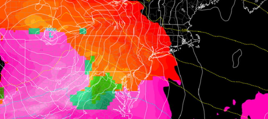
The upper levels are not screaming a major blizzard. The 250mb jet should actually be overhead not well to our S. This should help intensify the low pressure as it tracks E towards the Atlantic Ocean. By the time the low pressure redevelops near the Gulf of Maine it should be sub-990mb. The low however will track to the N and W of NJ which means at some point we’ll likely deal with a short-duration warm sector. But until that warm sector arrives via warm front (from the SW), over-running precipitation should start out as snow in New Jersey on Saturday. There are differences in model guidance on Saturday start time but most are now suggesting noonish instead of earlier in the morning. With that said we are now looking at colder overnight snowfall (Saturday night into early Sunday morning) instead of peak daytime snowfall. It would all wrap up by early Sunday morning with very cold air to follow for next week.
So snowfall should breakout statewide on Saturday. A snow/rain line should then start in Cape May and advance northward through SNJ, CNJ and ultimately parts of NNJ. The lower-mid levels (850-700mb) will advect first with the surface to follow. The recent trends however suggest that most of the precipitation falls first as snow before changing to less rain at the end. We’ve seen systems like these before (~New Years 2013-2014) where precip actually ends before changing to rain. Therefore the low-mid levels advect with warmth but the surface remains locked with cold. I’m not saying this will happen exactly as-described again but I AM leaning towards more snow up front and less rain to end.
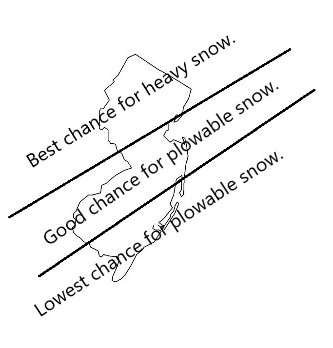
NWNJ has the best chance to see major (double-digit) snowfall accumulations. The I-95 corridor has a solid chance to see plowable snow accumulations. SENJ, since it will be changing over to rain first, has the best chance to only see a few inches of snow. I made the following diagram to illustrate these current thoughts from this range. I would expect some changes but this is the best I can do for right now:
We won’t have snow maps posted until probably Wednesday or even Thursday. From now until then we will be tracking seriously and will update accordingly (high level detail publicly, just like this article, and low-level detail, including run-by-run model analysis, in the premium forum). If the SE Canadian block verifies stronger then we could see an even snowier (less ending rain) solution than currently modeled. If the block verifies weaker then we could see a warmer outcome. This is the primary feature we’ll be tracking this week. It’s the coldest annual time of year so climatologically we kind of have to lean colder especially when processes like Cold Air Damming (CAD) happen against the Appalachian Mountains.
In English: The entire state of New Jersey will see temperatures drop below-freezing with the Thursday night cold front. Friday should then stay cold into Saturday morning with statewide snowfall beginning as early as noon Saturday. Snow should change to rain from S to N. Parts of NJ (likely NWNJ) might never change to rain and are therefore favored for the most snow. The I-95 corridor should see less snow than NWNJ but possibly still plowable. SENJ will likely see the least amount of snow since SENJ will change over to rain the quickest. At this point there will be public daily article updates at 5pm covering the previous 24 hours of model guidance and live observations. Snow maps will likely start by Wednesday or Thursday. A reminder that this system only starts our prolonged cold pattern. I am already seeing other winter storm signals in the Jan 22, 25 and 28 periods. Winter is on! Be safe! JC
Download the new free Weather NJ mobile app on Apple and/or Android. It’s the easiest way to never miss Weather NJ content. Our premium services go even further above and beyond at the hyper-local level. Looking for industrial-caliber long-range forecasting data that I personally recommend? Check out WeatherTrends360! Visit the Weather NJ Kaboom Shop for hoodies, tees and infant onesies.
Jonathan Carr (JC) is the founder and sole operator of Weather NJ, New Jersey’s largest independent weather reporting agency. Since 2010, Jonathan has provided weather safety discussion and forecasting services for New Jersey and surrounding areas through the web and social media. Originally branded as Severe NJ Weather (before 2014), Weather NJ is proud to bring you accurate and responsible forecast discussion ahead of high-stakes weather scenarios that impact this great garden state of ours. All Weather. All New Jersey.™ Be safe! JC


LOCAL FORECAST | INTERACTIVE RADAR | LATEST NJ WEATHER ALERTS | WEDDING FORECAST| PRIVACY POLICY
© Copyright 2026 Weather NJ LLC. All Rights Reserved.
Some information that can be found on our website is provided by a private weather station and is not an officially recognized station for weather reporting. Though we always strive to achieve accurate reporting for our own use, it is important that you do NOT depend on the data provided here for any purpose.
