

Jan 14: The Tale of Two Systems
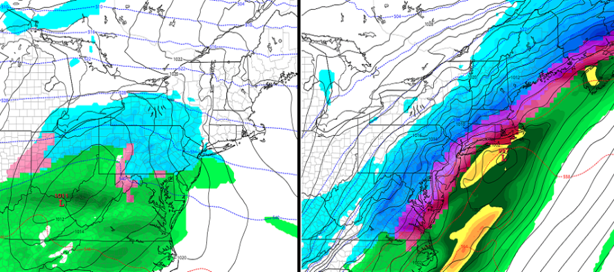

Discussion: While most of the focus is on the bigger weekend potential, we cannot drop our guard for a sneaky wave Thursday night into Friday morning. Energy is just coming off the Pacific Ocean onto California for this first system. The energy is expected to cross the US right through Kansas/Oklahoma. Ultimately it should deliver a light-to-moderate snow event to the interior northern Mid-Atlantic and Northeast US. In shooting from the hip from this range, the system could start as snow for many. SNJ would likely change over to rain very quickly (if not starting as rain already). CNJ would change over next and NNJ over last (if it warms enough). I could see the snow/rain line starting somewhere between Philadelphia<->Toms River and then lifting northward through NJ.
The way it looks right now only areas N of I-78 and NW of I-287 would see accumulating snowfall from the first system when all is said and done. Any accumulations in CNJ or SNJ from the front-end snow thump Thursday night would likely be washed away either immediately or by Friday morning. Once this first system clears out to our ENE it will pull down cold air behind it. It will also pull down the eventual track of the second system later in the weekend. Therefore the stronger the first system, the further S the second system will track. This is not the only factor in the second system’s track but a big part of it.
The second system looks to arrive in a more of a strung-out wave rather than a tightly-coiled organized and concentric surface low. The ingredients are there (W US ridge + tropospheric polar vortex cold + a country-crossing shortwave off the Pacific Ocean). I’m not crazy about the upper-level low just off the NW US. I feel like this can mess with the ridge and flatten out the jet a little. This would mean less of a major storm threat for the Mid-Atlantic but might mean a snowier outcome further S in New Jersey. Right now models are warm for the lower 2/3 of New Jersey. Only NWNJ is modeled for snowfall from the Saturday night into Sunday potential. It’s worth noting that yesterday’s system was also modeled N from this time-range. IMO the polar vortex suppression was underestimated by the models then and they might be now for this weekend. I would not be surprised to see the Sat-Sun system trend southward over the next few days. Either way, we won’t have a solid handle on the second system until we see what the first does. Something worth mentioning is the full moon this weekend. Should an easterly wind component establish from the perfect low positioning then we could be dealing with coastal flooding. But as long as the system remains like a wave instead of wrapped-up low it should not be too much of an issue.
After this weekend strong blocking looks to establish near Greenland. This should trap the remaining tropospheric polar vortex in SE Canada and possibly even retrograde such further S towards the NE US border. If this happens we can expect a long punishing period of bitter cold and active winter storm chances to end January and sustain well into February. I haven’t seen this look since the crazy winters of 2009-2010 and 2010-2011. I hope everyone is ready for quite the wintry ride.
In English: System one should move through NJ Thursday night into Friday morning. It looks like a snow to rain situation for most of NJ except NWNJ. Therefore I’m only seeing light to possibly significant accumulations for NWNJ. For this we will define NWNJ as N of I-78/NW of I-287). System one is closer in time and therefore carries more confidence. System two still looks like the bigger potential for accumulating snowfall. NWNJ is also currently favored for accumulating snow from system two but I’ll be watching for this to trend southward through this week. There might also be some icing concerns with system two. Let’s see how system one will play out first. The first snow map for system one will go out tomorrow along with an updated discussion for system two. Over 10,000 people have now downloaded the free Weather NJ mobile app on Apple and/or Android. It’s a great way to never miss an article from me as well as many other useful weather tools. Have a great night and please be safe! JC
Jonathan Carr (JC) is the founder and sole operator of Weather NJ, New Jersey’s largest independent weather reporting agency. Since 2010, Jonathan has provided weather safety discussion and forecasting services for New Jersey and surrounding areas through the web and social media. Originally branded as Severe NJ Weather (before 2014), Weather NJ is proud to bring you accurate and responsible forecast discussion ahead of high-stakes weather scenarios that impact this great garden state of ours. All Weather. All New Jersey.™ Be safe! JC


LOCAL FORECAST | INTERACTIVE RADAR | LATEST NJ WEATHER ALERTS | WEDDING FORECAST| PRIVACY POLICY
© Copyright 2026 Weather NJ LLC. All Rights Reserved.
Some information that can be found on our website is provided by a private weather station and is not an officially recognized station for weather reporting. Though we always strive to achieve accurate reporting for our own use, it is important that you do NOT depend on the data provided here for any purpose.
