

Jan 14: Tues Snow Map and Wed-Thurs Discussion
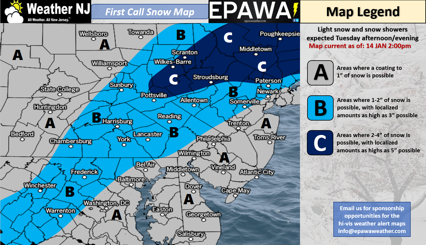
Click here for full resolution snow map!
Discussion: Real quick, we could see some ocean-effect snow showers move off the ocean onto SENJ on Monday. Little-to-no accumulation is expected but a cool micro-climate occurrence for sure! The above map is for initial snow showers Tuesday afternoon-evening. This will be mainly from weak energy strung out ahead of the closed-off upper-level low expected to dive into the US. It’s a light event however the colder temperatures should allow for higher snow ratios. Therefore it looks fairly easy for any part of New Jersey to see a coating to an inch or so. NNJ is favored, as the map indicates, to see the highest totals from this first Tuesday event.
Once this event concludes on Tuesday evening, the upper-level low is either going to close-off near the Kentucky/Ohio region and deepen before exiting into the Atlantic…or remain open as a positive-tilted trough. The former is what the Euro is suggesting and the latter is what the GFS and most other guidance is suggesting. The former would mean a low closer to the coast with a possibly significant snow event. The latter would mean an out to sea miss.
I was never really enthused about the Tuesday event becoming something bigger. I’ve always been more enthused about the Wed-Thurs potential and the Euro (Op and ensembles) is as well. We saw some flip-flopping on models over the weekend as expected but as of right now you cannot take the possibility off the table. We need another 24 hours of guidance and live-obs before we decide to roll out snow maps for Wed-Thurs or not.
Regardless of whether or not the low cuts off, we do have a trough axis swinging from positive to near-neutral. We also have a much weaker expected surface low than the Jan 4th coastal system. Therefore if the Wed-Thurs system were to come to fruition, it would likely be a plowable but not major snow storm favoring points along and SE of 95/NJTP again. Let’s see where we stand tomorrow when we post a final map for Tuesday’s initial light event.
In English: A few light flurries and snow showers could move off the ocean onto SENJ/Coastal NJ on Monday producing little-to-no accumulation. Light snowfall is then possible on Tuesday between afternoon and evening hours. NNJ is favored for accumulations as the above impact map indicates. We’re then still watching the Wednesday-Thursday signal for a possible (significant) coastal snow storm. This entire period this week should stay on the colder side. I’m not seeing a moderation in temperatures until the weekend. The Monday-Friday Outlook will be released early tomorrow morning and will speak to any overnight model trends. Have a great rest of your Sunday and please be safe! JC
For comprehensive and interactive hyper-local analysis that goes way above and beyond the detail of this public forecast, check out our premium services which include text notifications and forum access.
Jonathan Carr (JC) is the founder and sole operator of Weather NJ, New Jersey’s largest independent weather reporting agency. Since 2010, Jonathan has provided weather safety discussion and forecasting services for New Jersey and surrounding areas through the web and social media. Originally branded as Severe NJ Weather (before 2014), Weather NJ is proud to bring you accurate and responsible forecast discussion ahead of high-stakes weather scenarios that impact this great garden state of ours. All Weather. All New Jersey.™ Be safe! JC


LOCAL FORECAST | INTERACTIVE RADAR | LATEST NJ WEATHER ALERTS | WEDDING FORECAST| PRIVACY POLICY
© Copyright 2026 Weather NJ LLC. All Rights Reserved.
Some information that can be found on our website is provided by a private weather station and is not an officially recognized station for weather reporting. Though we always strive to achieve accurate reporting for our own use, it is important that you do NOT depend on the data provided here for any purpose.
