

Jan 15: Final Call Snow Map
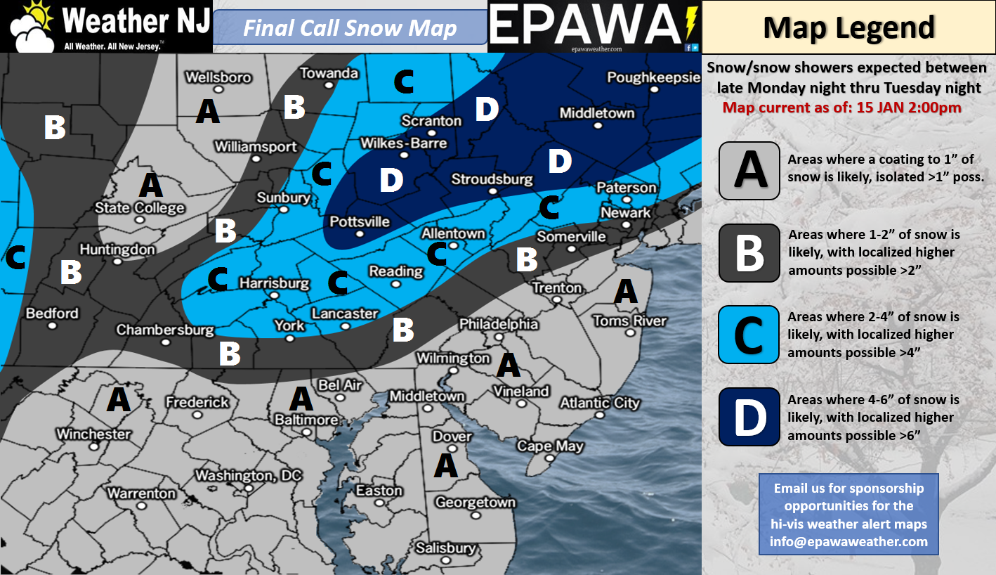
Click here to view full resolution snow map!
Discussion: A frontal boundary attached to a Great Lakes low pressure system will slowly push across New Jersey. This frontal boundary will feature wintry precipitation along it and will slowly pivot from positive to neutral as it departs the east coast. The area of least pivot movement runs through the Poconos and NNJ elevations N of I-80 which is where zone D is. Zone C could be slightly underdone and end up like zone D should there be more coastal enhancement by the baby low expected to form. This baby low is a double-edged sword however. It could throw a shallow warm layer as far NW as I-95 and maybe even up to I-78.
Most layers are cold to begin with but the coastal plain could easily warm at the surface and the low-mid layers. Therefore you might be seeing a lot of natural surface-only accumulations along and SE of 95. This system really only favors areas N of I-78 (running through NJ) for plowable accumulations. All of NJ to the S of I-78 will likely face mixing or other accumulation preventative issues.
The Wednesday into Thursday coastal potential continues to fizzle. I’m still 80/20 not happening/happening and will be 100% one way or the other after overnight model runs tomorrow morning. It would take a lot to overcome the progressive setup and positive-tilted trough axis. The upper level low would have to close off much sooner than the current guidance consensus. It’s possible but not looking good at this point. One more model suite before throwing the towel.
In English: Snowfall is possible tomorrow. I would expect NNJ to get going earliest by late-afternoon followed by CNJ and SNJ later Tuesday evening into overnight. Everything should taper off Wednesday morning with NNJ likely seeing the jackpot accumulations from this event. CNJ and especially SNJ are likely subject to less accumulations due to temperature issues and less time under the passing front. I’m still keeping an eye on additional accumulations for SENJ Wednesday into Thursday but we’re running out of time and it doesn’t look good (as in very little additional snowfall possible). Have a great night and please be safe! JC
For comprehensive and interactive hyper-local analysis that goes way above and beyond the detail of this public forecast, check out our premium services which include text notifications and forum access.
Jonathan Carr (JC) is the founder and sole operator of Weather NJ, New Jersey’s largest independent weather reporting agency. Since 2010, Jonathan has provided weather safety discussion and forecasting services for New Jersey and surrounding areas through the web and social media. Originally branded as Severe NJ Weather (before 2014), Weather NJ is proud to bring you accurate and responsible forecast discussion ahead of high-stakes weather scenarios that impact this great garden state of ours. All Weather. All New Jersey.™ Be safe! JC


LOCAL FORECAST | INTERACTIVE RADAR | LATEST NJ WEATHER ALERTS | WEDDING FORECAST| PRIVACY POLICY
© Copyright 2026 Weather NJ LLC. All Rights Reserved.
Some information that can be found on our website is provided by a private weather station and is not an officially recognized station for weather reporting. Though we always strive to achieve accurate reporting for our own use, it is important that you do NOT depend on the data provided here for any purpose.
