

Jan 15: Snow Map for System One
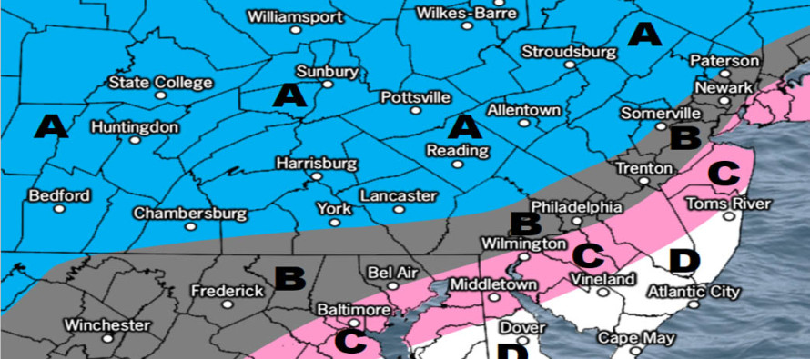

Discussion: My main focus right now is on the first Thursday night-Friday morning system. This is an overall weak system that came onshore yesterday off the Pacific Ocean (onto California). From now until Thursday it should track from W to E relatively flat across the US through S Kansas latitude before disorganizing near the Ohio/PA border. The associated precipitation shield however should move right through NJ between Thursday night and Friday morning. Most data is pointing towards a front-end snow thump changing to rain for those along and SE of the I-95 corridor (NJTP). Areas NW of I-95/NJTP should change over last, if at all, and therefore should expect the highest snowfall accumulations from this system. But even for NWNJ areas that see all snow, it’s a quick-moving system and only so much can fall in such a short time. I suspect the elevations of NWNJ will do the absolute best which warrants the caveat for the A area.
Some short range guidance is coming in colder like the American NAM model. However we’re a little outside of it’s wheelhouse range. The Canadian supports a colder scenario but the GFS and Euro currently support the snow/rain line advancing northward through the precipitation. By the time the snow/rain line makes it to about I-80 precipitation shuts off. If the data continues to lean colder for Thursday night into Friday morning then we might adjust this map colder tomorrow. That would bring more of CNJ into the higher expected amounts and possibly some of interior SNJ. Let’s see where the data and live observations point us tomorrow.
The later weekend storm system is still looking warm for anyone SE of NWNJ. The energy associated with this system is still offshore of the W US coast and therefore is not sampled properly. Tomorrow night we’ll be getting close to enhanced “over-ground sensors” but we might not be there until Thursday. We also have to see where the low from the first Thursday-Friday system orients the baroclinic zone in its wake. That is where the thermal gradient will set up and steer the later weekend storm system. If the N flow behind the Thursday-Friday system can pull the baroclinic zone further S then the weekend storm will trend colder as we closer approach. For now it looks warm for the lower 2/3 of NJ. I expect models to flip and flop between now and Thursday. Therefore serious storm tracking will begin on Thursday for system two (the later weekend system).
Should the later weekend system verify as currently modeled then we could be looking at two safety hazards in addition to snow and ice types of precipitation. One would be flash flooding from heavy rainfall. Two would be flash-freezing immediately after the precipitation moves away. Serious cold is expected Sunday night into Monday. Anything that does not evaporate would most-certainly freeze.
In English: For a full-resolution snow map please click here. More snowfall should impact New Jersey starting late this Thursday night and ending Friday morning. Temperatures are expected to warm from S to N during the event. Therefore a snow/rain line should start somewhere in SNJ and work it’s way northward through CNJ overnight. NNJ might stay all snow and therefore should do best with snowfall accumulations (especially NWNJ elevations). Cape May would have the best chance to start as rain and stay all rain. I’m still monitoring the later weekend second system. It still looks warm for most of NJ (NWNJ favored the coldest) but models are all over the place. One more day of early-discussion (tomorrow) and then serious storm tracking would begin on Thursday. We need to see where the first system (snow map above) ends up and how its atmospheric wake will impact the track of the second system. But to recap and summarize, both systems favor NWNJ for snow and SENJ for rain. With these approaching systems it’s not a bad time to download the new free Weather NJ mobile app on Apple and/or Android. Have a great rest of your evening and please be safe! JC
Jonathan Carr (JC) is the founder and sole operator of Weather NJ, New Jersey’s largest independent weather reporting agency. Since 2010, Jonathan has provided weather safety discussion and forecasting services for New Jersey and surrounding areas through the web and social media. Originally branded as Severe NJ Weather (before 2014), Weather NJ is proud to bring you accurate and responsible forecast discussion ahead of high-stakes weather scenarios that impact this great garden state of ours. All Weather. All New Jersey.™ Be safe! JC


LOCAL FORECAST | INTERACTIVE RADAR | LATEST NJ WEATHER ALERTS | WEDDING FORECAST| PRIVACY POLICY
© Copyright 2026 Weather NJ LLC. All Rights Reserved.
Some information that can be found on our website is provided by a private weather station and is not an officially recognized station for weather reporting. Though we always strive to achieve accurate reporting for our own use, it is important that you do NOT depend on the data provided here for any purpose.
