

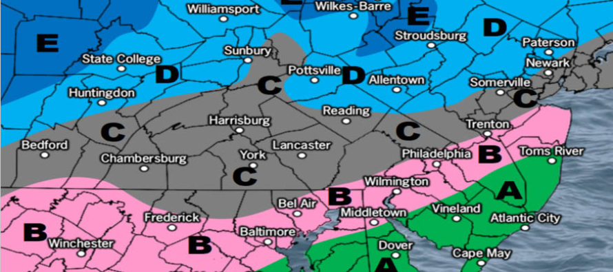
Jan 16: Initial Map for Saturday
Discussion: Today I tested positive for the flu (infuenza A strain) and so did my 5-month old daughter. It’s been a very bad week and I apologize for seeming to be MIA. I’ve been trying to rest and hydrate as much as possible but other aspects of my life have simply suffered. As soon as I post this article I’m heading back to sleep for probably the night. I am hoping to feel better tomorrow so I can help my wife care for our little one.
If you are a snow lover the bad news will continue to pile up about Saturday. We simply have way too many aspects working against big snow accumulations. First, the primary low will be tracking close to the Great Lakes which will guarantee an aggressive warm sector across New Jersey. We knew this all week but it looks warmer than ever now on guidance and live obs. Second, warm air advection in the low-mid levels (700-850mb) will be equally aggressive and likely inhibit proper dendrite growth for the snow that does fall. For this reason, we should also see a transition from initial snow to sleet rather quickly especially S of I-78/SE of I-287. For these reasons we are going very low for our initial snow map:
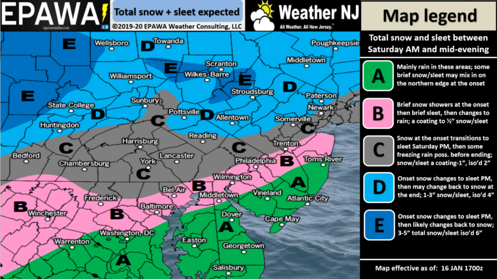
Click here to view full-resolution snow map!
I will remind everyone again that this system is kicking off a prolonged period of cold and active conditions for the Mid-Atlantic US. It won’t be long before we’re tracking another snowstorm likely before January’s end.
In English: We do have some wintry weather to start on Saturday but it should be short lived before changing over to sleet, freezing rain or plain rain rather quickly. NWNJ has the best chance to stack up some plowable inches of snow. NENJ/CNJ/SWNJ have the best chance for ice (sleet or freezing rain). SENJ has best chance to change to plain rain the quickest. The above snow map represents our initial thoughts. Snow should first approach NJ from the W by late-morning Saturday. Precipitation should taper off by about 8pm Saturday evening. As the above discussion indicates I’m now going to hibernate and try to beat the flu. Thanks and be safe! JC
Download the new free Weather NJ mobile app on Apple and/or Android. It’s the easiest way to never miss Weather NJ content. Our premium services go even further above and beyond at the hyper-local level. Looking for industrial-caliber long-range forecasting data that I personally recommend? Check out WeatherTrends360! Visit the Weather NJ Kaboom Shop for hoodies, tees and infant onesies.
Jonathan Carr (JC) is the founder and sole operator of Weather NJ, New Jersey’s largest independent weather reporting agency. Since 2010, Jonathan has provided weather safety discussion and forecasting services for New Jersey and surrounding areas through the web and social media. Originally branded as Severe NJ Weather (before 2014), Weather NJ is proud to bring you accurate and responsible forecast discussion ahead of high-stakes weather scenarios that impact this great garden state of ours. All Weather. All New Jersey.™ Be safe! JC


LOCAL FORECAST | INTERACTIVE RADAR | LATEST NJ WEATHER ALERTS | WEDDING FORECAST| PRIVACY POLICY
© Copyright 2026 Weather NJ LLC. All Rights Reserved.
Some information that can be found on our website is provided by a private weather station and is not an officially recognized station for weather reporting. Though we always strive to achieve accurate reporting for our own use, it is important that you do NOT depend on the data provided here for any purpose.
