

Jan 16: Winter Weather Update
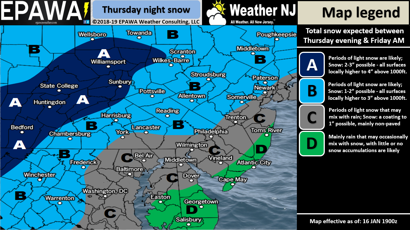

Discussion: Just like this past weekend for SNJ, this first system is not that big of a deal. However, it doesn’t take much to present safety hazards especially when the morning rush hour commute is affected. The first system should start as snowfall for most of NJ around midnight Thursday night and end by 9am Friday morning. The system overall is looking colder than it did yesterday however the precipitation shield appears weaker and scattered out. Remember, a snow/rain line is expected to start out somewhere in SNJ/SENJ and advance northward throughout the period of precipitation. We think this snow/rain line will make it to somewhere near or just NW of I-95/NJTP before precipitation shuts off. It will be the surface and 925mb layers that see the greatest warm-air advection. 850mb and 700mb actually look cold enough to support snowfall. If the lower-levels are slow to warm then you might see more white rain than rain. Areas NW of I-95 stand the best chance for light accumulations. Again, this will time poorly with NNJ rush hour commuting. CNJ and SNJ.
Just to discuss a few wildcard differentials, let’s consider the following. If trends continue colder with weaker precipitation then it will be more moisture-starved. We could then be looking at a statewide coating to an inch at most. If the system comes in more robust then it would be easy for the higher NNJ elevations to reach the 3+ inch mark but would mean a quicker changeover from S to N. Between these wildcard scenarios for Thursday night into Friday morning exists our most reasonable call represented by the snow map above.
Onto system number two for the weekend. Tomorrow we will issue our first map for this system. Today is the last day we are monitoring trends and how the first system impacts this system while crossing the US. Models continue to flip and flop. The theme remains that NWNJ has the best chance to see heavy snowfall and SENJ has the best chance to see rain. Everyone in-between is likely looking multiple changeovers. First from snow to ice to rain then back to ice and then snow. With that said CNJ, which includes the axis of Philadelphia and New York City, could be looking at a significant icing event. A lot of warm moist air will be clashing into an Arctic wall of cold. This thermal gradient is what fuels mid-latitude cyclone development…the same way warm water fuels tropical cyclones via latent heat exchange and evaporation. Where I’m going is that this should be a stronger synoptic storm with a high level of volatility in storm track. With the battleground of snow vs ice vs rain running right through CNJ (along I-95/NJTP) there is still a lot of time for model trends and unforeseen live observations. This is why we are waiting until tomorrow for the first snow map.
I would expect higher winds with the weekend storm. Also, temperatures are expected to drop like a tranq-darted fool once the system moves through. I’ll talk more about the flash freeze and flash flooding potential in tomorrow’s article. You’ll have the synoptic winds that rock around the low followed by the NW cold winds that follow into Monday. With the ice and wind potential I imagine there will be power outages. Sunday is looking like a day best spent inside regardless of how this pans out.
In English: For a full-resolution snow map please click here. Light snow is expected to move through between late Thursday night and about 9am on Friday. NWNJ is favored to see the most snow. SENJ could start snowy but change over to rain. The above snow map represents our current best guess of wintry accumulations. The weekend system is still looking larger with higher impacts. NWNJ could see heavy snow while the rest of NJ is subject to ice and rain. I’ll have impact maps for both snow and ice for the weekend system tomorrow. With these approaching systems it’s not a bad time to download the new free Weather NJ mobile app on Apple and/or Android. Have a great rest of your evening and please be safe! JC
Jonathan Carr (JC) is the founder and sole operator of Weather NJ, New Jersey’s largest independent weather reporting agency. Since 2010, Jonathan has provided weather safety discussion and forecasting services for New Jersey and surrounding areas through the web and social media. Originally branded as Severe NJ Weather (before 2014), Weather NJ is proud to bring you accurate and responsible forecast discussion ahead of high-stakes weather scenarios that impact this great garden state of ours. All Weather. All New Jersey.™ Be safe! JC


LOCAL FORECAST | INTERACTIVE RADAR | LATEST NJ WEATHER ALERTS | WEDDING FORECAST| PRIVACY POLICY
© Copyright 2026 Weather NJ LLC. All Rights Reserved.
Some information that can be found on our website is provided by a private weather station and is not an officially recognized station for weather reporting. Though we always strive to achieve accurate reporting for our own use, it is important that you do NOT depend on the data provided here for any purpose.
