

Jan 18: Snow Ice and Rain Storm Approaching

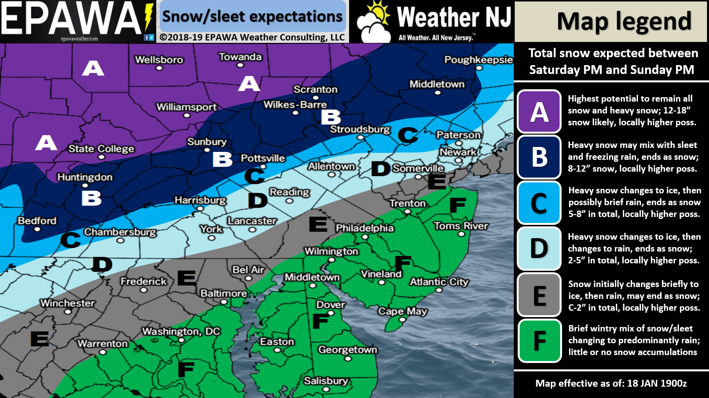
For full-resolution snow map please click here!
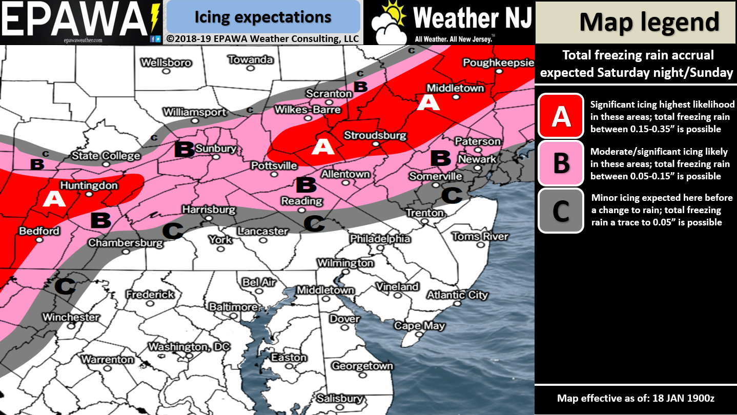
For full-resolution ice map please click here!
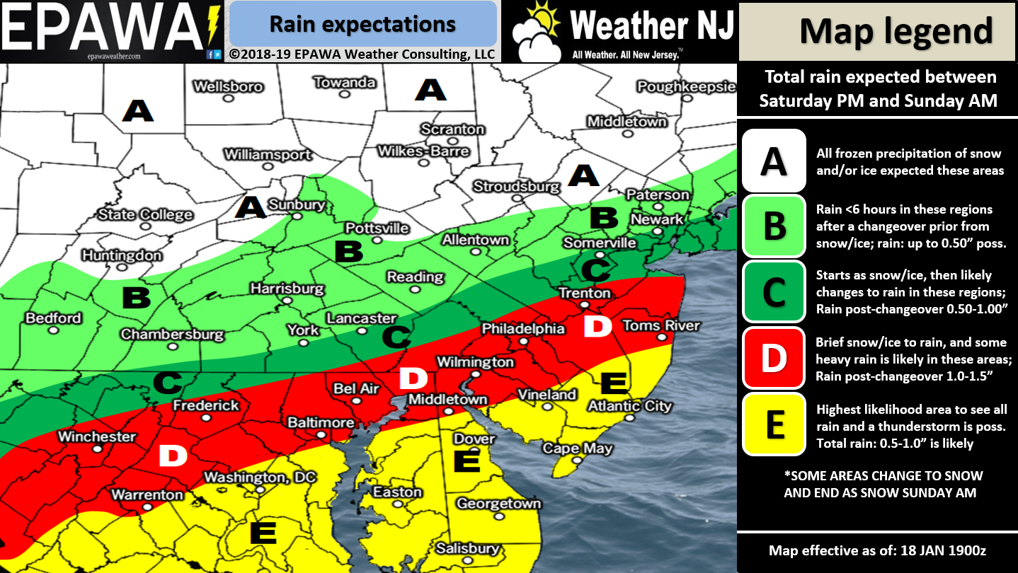
For full-resolution rain map please click here!
Discussion: This storm system is very complex both in mesoscale components and change over duration of the event. It is not a clear-cut and simple “Will I get snow, ice or rain?” for any location. Therefore let’s break down NJ impacts based on the unique characteristics of each storm phase:
Phase 1: Initial Snow Thump
If any phase of this system is going to surprise it will be the initial snow thump. This will be overrunning snowfall well ahead of the warm-air advection in the warm sector. The low will be far to our W/SW at this point. This phase would begin around 6pm in WNJ and reach ENJ by 8pm. During this initial snow thump even areas slightly SE of the NJTP could start out snowy. Most to the SE of NJTP however would start as a mix of non-accumulating snow/rain. I’ve seen many instances of front-end snow over-performing and jacking up actual snowfall amounts so this is something those along and NW of NJTP will have to pay attention to. Our snowmap above illustrates the best blend of data available but my gut says we will verify slightly colder with this system especially in this front-end snow thump phase.
Phase 2: Warm Sector Ice and Rain
Temperatures are expected to rise in the lower-levels (975mb up to 850mb) shortly after the front-end snow thump. Temperatures might hold onto cold at the 700mb and surface however for NNJ/NWNJ. This is mainly due to warm-air advection associated with the S/SE flow ahead of the low. When the low gets closer to NJ it will have the most impact in this phase. This creates a scenario of decent snow formation that falls through the warmer lower-levels before hitting the ground. The warmer levels either melt the dendrites slightly, in a shallow warm lower-level, before hitting the ground (sleet). Or if there is a deeper lower-level warm layer then a complete melt to a raindrop that hits a frozen surface (freezing rain). Both ice types of precipitation are possible with this system. Ice is a much larger concern for those along and NW of NJTP rather than SE of. Just like my gut feel says the front-end snow thump could over-perform, I could see this phase 2 over-perform on the warmer side meaning more of a changeover to ice and rain for areas further N in NJ. If it doesn’t then obviously snow totals would be blown over expectations in NNJ/NWNJ. Again, lots of volatility with each phase of this system.
SNJ/SENJ temperatures are expected to spike unseasonably high during this warmer mid-phase of the system. You might see 50F maybe even 60F reached Sunday morning when the warm sector is ripping. On the other side of the NJTP (in PA and NY) temperatures are expected to be the total opposite…unseasonably cold. This is the thermal gradient that will power explosive frontogenesis and cyclogenesis through the main area of wintry impact (mainly NNJ, NWNJ and parts of WCNJ). This phase like the others will have to be now-casted between late-Saturday night and Sunday morning.
Phase 3: Crashing Temps Back to Snow
Once the low is E of NJ longitude temperatures will crash hard with northerly winds. Back-end precipitation is always hard to call but I believe that if there is still a snow/ice/rain line that it will be pulled back down to at least the NJTP before precipitation finishes. This could produce additional snow accumulations for areas that were possibly just washed away and/or impacted by ice and rain. Like all other phases NWNJ is most favored for this to happen. This would likely be a very brief period, if it happens, later Sunday morning/early Sunday afternoon. I wouldn’t hold my breath on this third phase of impact but it is not off the table.
Phase 4: Flash Freeze Potential
Lastly, once precipitation clears out to the E Sunday afternoon, temperatures will continue to drop well-below freezing statewide. By Sunset on Sunday you should really feel the bitter cold. Any moisture on the ground that has not yet evaporated will absolutely freeze. This especially goes for road treatments that might have been washed away by the warmer second phase of rainfall. We haven’t faced a flash-freeze scenario like this in a long time. Therefore the greatest safety hazard of this phase will be slippery road conditions from about sunset on Sunday into the bitter-cold overnight hours into Monday morning. Wind chills should be wicked with many values BELOW-ZERO for much of the state.
In English: I’ve laid out the different phases of this system above. Basically for NWNJ it’s snow to ice to rain possibly back to snow. For SENJ it’s mostly rain with flash flooding and minor coastal flooding possible. SENJ should spike to very warm temperatures Sunday morning. I wouldn’t rule out a few embedded boomers especially for areas that reach 60F. The fog could be for real too. For everyone in-between it’s a nowcasting event as far as how much snow falls during the initial thump Saturday night vs how warm we get Sunday morning vs how much snow will be on the back-end once temperatures crash later in the day Sunday. Afterwards the entire state is subject to a flash freeze where any water that does not evaporate will freeze if untreated. This is where we’re at now. It’s a complex system that deserves a complex forecast. Find out why over 14,000 people have now downloaded the new free Weather NJ mobile app on Apple and/or Android. It’s the easiest way to never miss Weather NJ content. Have a great rest of your evening and please be safe! JC
Jonathan Carr (JC) is the founder and sole operator of Weather NJ, New Jersey’s largest independent weather reporting agency. Since 2010, Jonathan has provided weather safety discussion and forecasting services for New Jersey and surrounding areas through the web and social media. Originally branded as Severe NJ Weather (before 2014), Weather NJ is proud to bring you accurate and responsible forecast discussion ahead of high-stakes weather scenarios that impact this great garden state of ours. All Weather. All New Jersey.™ Be safe! JC


LOCAL FORECAST | INTERACTIVE RADAR | LATEST NJ WEATHER ALERTS | WEDDING FORECAST| PRIVACY POLICY
© Copyright 2026 Weather NJ LLC. All Rights Reserved.
Some information that can be found on our website is provided by a private weather station and is not an officially recognized station for weather reporting. Though we always strive to achieve accurate reporting for our own use, it is important that you do NOT depend on the data provided here for any purpose.
