

Jan 19: Major East Coast Winter Storm Update
We’re just 72 hours from a possible major east coast winter storm and here’s what the latest data tells us.
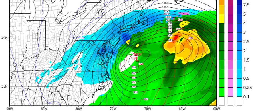
Today’s 12Z and 18Z model suites have trended colder for New Jersey. This means less potential mixing to the SE of I-95 and more snowfall. Let me be crystal clear that not any one modeled solution should be taken as gospel at this point. Tonight’s 00Z model suite as well as tomorrow’s 12Z are absolutely critical for this storm as energy will be sampled better on land in the NW US. The GFS and Canadian crush most of New Jersey while the Euro only brought heavy snow to SNJ and lighter snow to NNJ. The best thing to do is sit back and take it all in. The model ensembles are almost all clustered together in a favorable location so the final outcome is likely somewhere between the spread of all current guidance.
We’ve dealt with widespread significant to heavy snowfall before (even 1-2 feet of it). We’ll dig out if that happens and road crews will do their best to get us back out there. What deeply concerns me is the coastal flooding potential setting up (from Cape May to Long Island including NYC). This will be a very large storm with a gigantic wind field. Once the onshore flow commences, it will push the ocean into the coast and back bays of the barrier islands. Couple that with a near-full moon and the several tidal cycles could present a moderate-to-high coastal flooding risk, especially during high tide. Rain or snow, winds should gust to 60mph along the coast. All relevant OEM, EMS and municipal/county/state authorities should be aware of this. I see this coastal flooding component of the storm being WAY underrated and underestimated due to everyone focusing on snow.

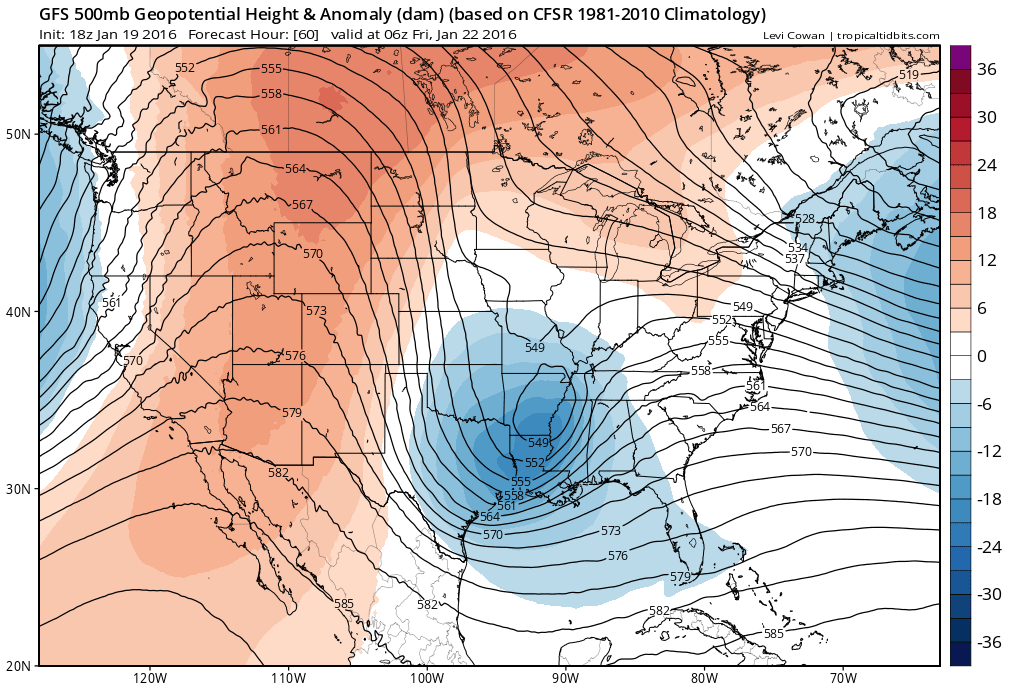
The following image is of the 500mb level showing heights and anomalies. This is the period (early Friday morning) that I will be closely monitoring. You can see the ridge in the W US which is dictating how deep the upper-level feature digs ahead of it. The reason some guidance came south today is because of the ridge being too amped and in turn pushing the system to the south. The Euro’s guidance still crushed SNJ with 1-2 feet but left NWNJ with little to no snow. The rest of the other guidance out there has the ridge less amped and therefore a slightly northern solution which crushes all of New Jersey. So I’ll be watching that short wave mature from the NW US down through the general Arkansas area as shown below. This will dictate the final track of the surface low as the upper-level low closes off and stacks on top of it while floating to the east coast. If the low passes closer to Delmarva then it means all of NJ gets rocked. If closer to OBX then maybe only SNJ gets rocked with NNJ seeing some snow. These detailed possibilities will be substantially narrowed down over the next 24 hours and will allow me to make as confident of a snow map as I can for tomorrow evening:
Another point worth mentioning is the warm surface temperatures of the Atlantic Ocean. While this still could bring some mixing to the SNJ coast, it could also help the rapid deepening of the coastal surface low when it ejects into the ocean. Just something to keep an eye on as the system evolves.
In English: A major east coast snow storm is becoming more likely in the Friday night to Sunday morning time window. Heavy snowfall, high winds, coastal flooding, and possibly some mixing for the SNJ coast are still very much on the table. Just a few more details need to be ironed out with the models tonight and tomorrow but we’re not getting any further away from this thing. If this holds through tomorrow’s afternoon models then it’s basically game on. I will have my first snow map posted tomorrow evening. Thanks again for your patience and understanding. Be safe! JC
Jonathan Carr (JC) is the founder and sole operator of Weather NJ, New Jersey’s largest independent weather reporting agency. Since 2010, Jonathan has provided weather safety discussion and forecasting services for New Jersey and surrounding areas through the web and social media. Originally branded as Severe NJ Weather (before 2014), Weather NJ is proud to bring you accurate and responsible forecast discussion ahead of high-stakes weather scenarios that impact this great garden state of ours. All Weather. All New Jersey.™ Be safe! JC


LOCAL FORECAST | INTERACTIVE RADAR | LATEST NJ WEATHER ALERTS | WEDDING FORECAST| PRIVACY POLICY
© Copyright 2026 Weather NJ LLC. All Rights Reserved.
Some information that can be found on our website is provided by a private weather station and is not an officially recognized station for weather reporting. Though we always strive to achieve accurate reporting for our own use, it is important that you do NOT depend on the data provided here for any purpose.
