

Jan 2: Coastal Snow Storm a GO!
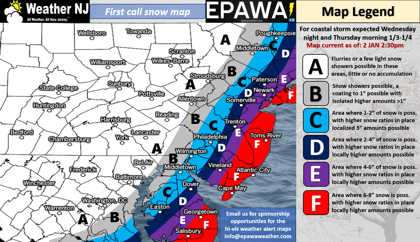
Please click here for full-resolution snow map!
Discussion: We’re finally transitioning from the mid-range to short-range forecasting period and therefore most major features of this system are locked-in. We know we have phasing energy to our W (will eventually phase for NE US/SE Canada). We know we will have a powerful ocean low tracking from S to N to our E. We know that the precipitation shield can only come so far to the W/NW due to confluence and and other upper-level inhibiting factors.
What we don’t know is how wild and wintry it can get along the coast (the red area on the above map) due to the last-minute micro-variability in storm track. For this reason, we’ve set a low bound of 6 inches but left the top bound open with a conservative 8+. If the low takes a further W track, it would have more impact along the coast than areas to the W like Philly and NWNJ (due to the confluence). The cut-off would still be sharp in W regions but more of interior NJ would see a plowable event and the red area could possibly Kaboom. If the low takes a further E track then impacts along the coast would be closer to the lower bound of expectations…in the red area’s case 6 inches.
Snow accumulations aside, this will be a very powerful ocean storm with high winds. The red area should expect sustained winds up to 25mph with gusts up to 45mph. This should create a blinding/blowing snow effect which will produce poor visibility. The winds also bring power outage potential as snowfall stacks on branches and power lines flapping in the wind. Lastly, the coldest air of the season is on it’s way for Friday-Sunday. Therefore wind, visibility and power outages should be prepared for. There are no major coastal flooding concerns due to the low positioning and northerly flow expectation. You might see slightly higher tides than normal but not a major storm surge event. Areas away from the ocean will see a lighter event both snowfall accumulation and wind-wise.
In English: A winter storm should occur this Thursday. You might see some action start in SENJ late Wednesday night but the majority of snowfall should start by early Thursday AM. Snow should then rip for most a large part of Thursday and taper off from W to E during Thursday PM hours. The above snow map represents our first call. We may need to increase expected coastal NJ totals tomorrow, possibly to the K-word…or decrease depending on how the next 18-24 hours of model guidance and live observations play out. Either way, expect gusty winds (especially closer to the coast) and the power outages/poor visibility that comes with blowing snow. Our final call will go out tomorrow with live-casting beginning tomorrow evening. You should then prepare for more pipe-bursting cold Friday through the weekend. Have a great night and be safe! JC
For comprehensive and interactive hyper-local analysis that goes way above and beyond the detail of this public forecast, check out our premium services which include text notifications and premium forum access.
Jonathan Carr (JC) is the founder and sole operator of Weather NJ, New Jersey’s largest independent weather reporting agency. Since 2010, Jonathan has provided weather safety discussion and forecasting services for New Jersey and surrounding areas through the web and social media. Originally branded as Severe NJ Weather (before 2014), Weather NJ is proud to bring you accurate and responsible forecast discussion ahead of high-stakes weather scenarios that impact this great garden state of ours. All Weather. All New Jersey.™ Be safe! JC


LOCAL FORECAST | INTERACTIVE RADAR | LATEST NJ WEATHER ALERTS | WEDDING FORECAST| PRIVACY POLICY
© Copyright 2026 Weather NJ LLC. All Rights Reserved.
Some information that can be found on our website is provided by a private weather station and is not an officially recognized station for weather reporting. Though we always strive to achieve accurate reporting for our own use, it is important that you do NOT depend on the data provided here for any purpose.
