

Jan 2: More Snow for NNJ
Discussion: After today’s milder conditions, all NJ temperatures should crash overnight tonight. We’re probably looking at a range of 20s to 30s from elevations to sea come 5-6am Sunday morning. The back-side of the departing low’s northerly cyclonic flow will be the culprit. This should keep tonight cold, clear and breezy as we eye up another low approaching for Sunday into Monday.
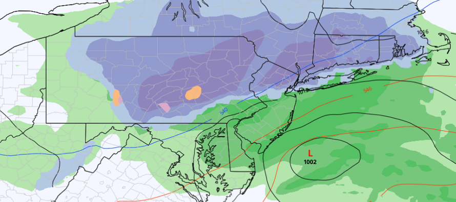
The low will start out over the interior NC/SC border early Sunday morning. It will then track to the E/NE and eject into the Atlantic Ocean somewhere near the Virginia Beach/OBX latitude by noon. From there it will gradually intensify (through Sunday PM/Monday AM) and swing/hook up towards coastal Canada by Monday PM//Tuesday AM—tracking just outside of the 40N/70W benchmark. This should produce a precipitation shield from the Carolinas up through much of the E coast from Sunday AM through early Monday AM.
An upper-level shortwave will also track into the NJ area from the W Sunday PM into Monday AM. This energy is what should help bomb the system out for the Gulf of Maine on Tuesday. But for Sunday-Monday in our area, it should assist some with the surface low intensification and provide a westward expansion of the precipitation shield into the NY/PA/NWNJ Appalachians. Shortwave-sfc low interaction but not in enough time for a full phase.
Temperatures profiles should be erratic, especially at the surface. As mentioned, we’re looking at a significant temperature drop overnight tonight. Aside from immediate coastal areas, most of NJ should drop below freezing. However once the front-side SE flow from the approaching low establishes (by Sunday AM), temperatures should warm above freezing for most of the lower 2/3 of NJ. This should keep most frozen surface precipitation hazards N of I-80/NW of I-287 on Sunday. No issues at the 850-700mb layers. They are all below freezing especially in the wake of the departing cyclonic flow. 925mb looks a little warm even N of I-80/NW of I-287 at times. This could mix more sleet into the rain/snow at times and keep the “plowable” event status even N of I-80/NW of I-287.
Assuming we have a snow/rain line somewhere near I-80/I-287 for daytime hours Sunday, that snow/rain line should then push S into more of NJ as we head into sunset hours. By sunset on Sunday, flow should be mostly N over NJ behind the departing low. It’s possible that the snow/rain line makes it as far S as I-78 (maybe further) before precipitation shuts off between late Sunday PM and early Monday AM.
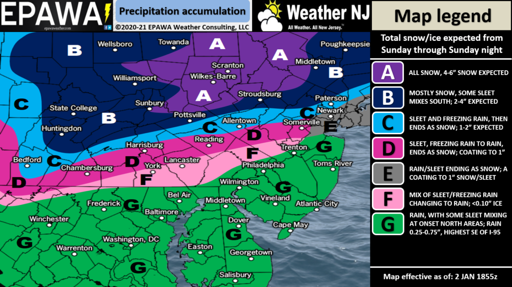
This is just a rain event for anyone along I-78 and S…maybe even I-80 and S. Such areas would likely only end as conversational snowfall with trace-to-light accumulations at best in the areas closest to NNJ. The low is weak and fast moving. Therefore, there are minimal coastal flooding concerns for ECNJ/SENJ, if any. The following snow map illustrates our current thoughts for Sunday AM through early Monday AM (most of the event occurring on Sunday):
After this Jan 3-4 system, there are more synoptic signals for Jan 8-9 and then Jan 13-15. The upper-level patterns (North America troposphere and polar stratosphere) are becoming very favorable for east coast snow storm support. Arctic air is available (-AO), there’s blocking downstream in the general Greenland region (-NAO), and ridging is now modeled for the W US (+PNA). This means an E US trough pattern is setting up for the Arctic air to spill into. The Polar Vortex is splitting in the stratosphere (evident at 50mb) which is allowing a Sudden Stratospheric Warning Event (SSWE) to occur. This mechanism expands the stratosphere upwards and downwards which squeezes the polar tropospheric cold into the lower latitudes of the N Hemisphere. That cold air should essentially spill into the E US trough pattern in the next few weeks. Again, a very favorable upper-level pattern to support any surface snow storms that spin up within a 7-day forecasting period. I’m excited to see how this plays out. We haven’t had a mid-to-late January setup like this in a while.
In English: Snow is expected for NWNJ between about noon Sunday and early Monday AM hours. Rain could start earlier Sunday for SNJ/CNJ. There is a good chance that sleet knocks expected plowable accumulations down for all but the higher elevations of NWNJ. If there is less sleet then more of NNJ could see a snowier outcome. Overall, a light wintry event for NNJ/NWNJ. The rest of NJ should see mostly rain during this time with maybe some wintry mix for parts of CNJ/NENJ. All rain SE of the turnpike. Please see our snow map above for more details. There are no wind or coastal flooding concerns. Have a great rest of your Saturday and please be safe! JC
Download the free Weather NJ mobile app on Apple or Android. It’s the easiest way to never miss Weather NJ content. Our premium services go even further above and beyond at the hyper-local level. Get your merch on at the KABOOM shop in time for the holidays.
Jonathan Carr (JC) is the founder and sole operator of Weather NJ, New Jersey’s largest independent weather reporting agency. Since 2010, Jonathan has provided weather safety discussion and forecasting services for New Jersey and surrounding areas through the web and social media. Originally branded as Severe NJ Weather (before 2014), Weather NJ is proud to bring you accurate and responsible forecast discussion ahead of high-stakes weather scenarios that impact this great garden state of ours. All Weather. All New Jersey.™ Be safe! JC


LOCAL FORECAST | INTERACTIVE RADAR | LATEST NJ WEATHER ALERTS | WEDDING FORECAST| PRIVACY POLICY
© Copyright 2026 Weather NJ LLC. All Rights Reserved.
Some information that can be found on our website is provided by a private weather station and is not an officially recognized station for weather reporting. Though we always strive to achieve accurate reporting for our own use, it is important that you do NOT depend on the data provided here for any purpose.
