

Jan 20: Final Call Map for Wednesday Snow
Here’s my final call for tomorrow’s snow..
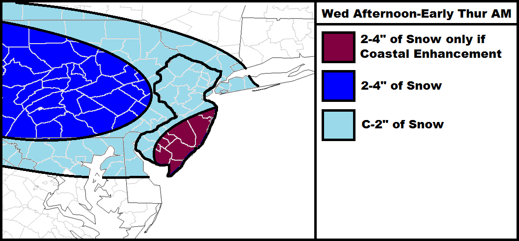
My rationale after reviewing the latest guidance is mostly based on a connection between the northern low and the coastal low (both weak). The darker blue area should see the most precipitation from the northern low as it dives in from the W/NW. Everywhere else is likely subject to a coating to a couple of inches. The purple area will only verify, and I repeat ONLY verify, if the coastal energy connection enhances the precipitation shield later tomorrow evening. This joined energy is modeled to become pretty robust as it moves away to the NE. If that happens a little bit earlier then the purple area verifies. Otherwise, just treat it like the widespread C-2″ light blue region.
It should also be mentioned that the purple area has the best chance to see a short period of rain during the onset of precipitation. We’ll have to monitor surface and lower atmosphere temps tomorrow before the system moves in. Ironically, this area has the potential for the highest accumulations after the changeover. We might re-visit that idea this weekend which I’ll talk more about later.
In English: Expect a general widespread coating to a few inches for the entire state. Should the storm intensify before pulling away, then SNJ/SENJ could see slightly higher accumulations. Snow should be knocking on our NW door as we approach noon tomorrow. By the time PM rush hour rolls around it could be getting pretty slick. Snow should then fall through late afternoon/early evening and clear out between late tomorrow evening and early Thursday AM. We’ll iron out any final adjustments during now-casting. Be safe! JC

Jonathan Carr (JC) is the founder and sole operator of Weather NJ, New Jersey’s largest independent weather reporting agency. Since 2010, Jonathan has provided weather safety discussion and forecasting services for New Jersey and surrounding areas through the web and social media. Originally branded as Severe NJ Weather (before 2014), Weather NJ is proud to bring you accurate and responsible forecast discussion ahead of high-stakes weather scenarios that impact this great garden state of ours. All Weather. All New Jersey.™ Be safe! JC


LOCAL FORECAST | INTERACTIVE RADAR | LATEST NJ WEATHER ALERTS | WEDDING FORECAST| PRIVACY POLICY
© Copyright 2026 Weather NJ LLC. All Rights Reserved.
Some information that can be found on our website is provided by a private weather station and is not an officially recognized station for weather reporting. Though we always strive to achieve accurate reporting for our own use, it is important that you do NOT depend on the data provided here for any purpose.
